Vertical Motion and Stability
Ideal Gas Law - Pressure*Volume = Temperature
If pressure dec., volume inc. and temp. dec.
If pressure inc., volume dec. and temperature inc.
The temperature changes described above are called adiabatic temperature changes. Temp. changes based on compression and expansion of air. No heat is added or removed.
In terms of dry air parcels, as a parcel rises it expands and cools, and the opposite occurs when it sinks. For every 1km this parcel rises and falls, it changes temperature by 10 degrees celcius. That is called the dry adiabatic lapse rate.
In terms of wet air parcels, the adiabatic lapse rate varies in a ratio from 5-9 degrees celcius per 1km. Rate of cooling depends on how much moisture is condensed. Condensation slows the rate of cooling as the air parcel continues to rise, because it releases a lot of heat.
LCL is the lifting condensation level at 3km. Parcel temperature reaches its dew point temperature here.
The Environmental Lapse Rate (ELR) is the actual rate at which atmospheric temperature decreases with increasing altitude. IN an absolute stable atmosphere, the ELR is less than DALR and the WALR. Determined from meterological observation (weather ballons)
Severe weather, including thunderstorms, tornadoes, and hail, is most likely when the atmosphere is unstable, meaning air is warmer and more moist near the surface than above
an inversion occurs when temperature increases with height
Processes that lift air
Orographic lifting - air is forced to rise and cool adiabatically as it moves over high terrain like mountains. The windward side is wet and cool and the leeward side is dry and warms. This condenses water vapor, creating clouds in precipitation.
Frontal Lifting - when different air masses meet, creating a front where less dense air is forced to rise over dense cold air. Leads to cloud formation and precipitation. COld fronts are more steep leading to thunderstorms while warm fronts have a more gentle slope creating widespread light precipitation. Stationary fronts occur when neither is strong enough to move.
Low level convergence - forcing horizontal air currents to meet and collide, inducing an upward motion. Creates cloud formation, instability, and precipation. Winds spiral inward towards a central point moving upward.
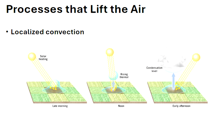
Localized convection - lifts air through uneven surface heating, creating warm thermals that are less dense than surrounding air. Air warms, expands, and rises forming cumulus clouds if moisture is sufficient. Create vertically developed clouds.
Atmospheric Stability - the propensity of an air parcel to rise or sink through the atmosphere by comparing it temperature to that of the surrounding air. Parcel temperature is determined using DALR and WALR.
Stable air - if the parcel is cooler than the surrounding air, it will isnk
Unstable air- if the parcel is warmer than the surrounding air, it will rise
Absolute stability (parcel cools faster) -
ELR < WALR < DALR
When dry adiabatic rate converts to wet adiabatic rate (condensation level occurs here), temerapture of rishing air decreases faster