UNIT 1: map shap
intro
physical geography: the study of the spatial characteristics of various elements of the physical environment.
think of the geographer in the little prince!!
ex: weather, climate, ecosystems, erosion
human geography: the study of spatial characters of humans and human activities.
ex: population, culture, urban areas, and economics
geographers dont only focus on where but more so WHY THERE
geography is the why of where
spatial approach: considers the arrangement of phenomena being studied across the surface of the earth
location, distance, direction, orientation, pattern and interconnection
movement of ppl and goods, chances in places over time, human perceptions of time and space
four level analysis
L1 (comprehension)
key questions:
what? (ex: earth at night)
where? (ex: earth)
when? (ex: 2016)
scale? (ex: global)
source? (ex: nasa.gov)
L2 (identification)
key questions:
are there any patterns in the source?
the source could be map/chart/graph etc. Could be multiple patterns (ex: numerous patterns- coasts are brighter than interior; Northern hemisphere is brighter than southern; etc)
L3 (explanation)
key questions (pick a pattern from source and explain):
why did this pattern occur there?
how did this pattern occur?
u will use the content of the course to help ans these qs
ex: access to global trade networks or nat resources from oceans (fish), which results in more job opportunities, income, and food. the interior often has harsher climates (desert or cold) and often less access to nat resources
L4 (prediction)
key questions:
what will be the impact of the economy, society, politics, or the environment?
what if the pattern continues into the future?
describing the impact or effects and make predictions
ex: IMPACTS
economic- cost of living (rent) is higher on the coasts bc of high demand for housing
environmental: human and factory waste can pollute the ocean, killing fish and wildlife
MAPS
reference maps: designed for ppl to refer for general info abt places
political maps: show and label human created boundaries and designations, like countries, cities, and capitals
physical maps: show and label nat features, like mts, rivers, ad deserts
road maps: show and label highways, streets, and alleys
plat maps: show and label property lines and deets of land ownership
locator maps: are illustrations used in books and ads to show specific locations mentioned in the text
thematic maps: show spatial aspects of info or of a phenomenon
choropleth maps: use various colors/shades of one color/ patterns to show the location and dist of spatial data
think republicans vs democrats maps to varying degrees
dot dist maps: used to show the specific location and dist of smth across a map (each dot reps a specific quantity)
think that each dot reps one of the thing, like a school
graduated symbol maps: use symbols of diff sizes to indicate diff amts of smth. Larger= more of thing, and vice versa
think pandemic maps
isolene maps: (aka isometric maps) use lines that connect pts of equal values to depict variations in the data across space
think storm system maps
topographic maps: points of equal elevation are connected on these maps creating contours (same thing/ synonyms)
cartogram: sizes of countries (or states/counties/ other areal units) are shown according to some specific stats
SCALE
map is a reduction of the actual land area it reps
scale: the ratio between the the size of things irl and the size of those same things on the map
three types of scale: cartographic, geographic, and the scale of the data repd on the map
cartographic: refers to the way the map communicates the ratio of its size to the size of what it reps
words:
ex: “1 in=10 miles”
ratio:
ex: 1/200,000 or 1:200,000 (means 1 unit of measurement on the map is equal to 200,000x the same unit irl
a line:
the map may show a line and indicate that its dist on the map reps ten miles irl (aka linear/geographic scale)
scale:
small-scale maps: show a larger amt of area w less deets (ex: global scale earth at night)
large scale maps: show a smaller amt of area w a greater amt of deets (ex: north america at night)
geographic scale: normally appears as a line or bar divided into conveniently numbered segments (
geographic model: reps of reality/theory, to help them to see general spatial patterns focus:
TYPES OF SPATIAL PATTERNS
Location
absolute location: precise spot where smth is according to a system
latitude: is the dist north or south of the equator (=0 degrees; the poles are 90 deg N and 90 deg S)
longitude: is the dist east/west of the prime meridian (runs thru greenwich, england). designated as 0, opp side is 180 deg longitude
relative location: description of where smth is in relation to other things
think: woh udhar hai uske paas
connectivity: how well two locations are tied together by roads or other links
accessibility: how quickly and easily ppl in one location can interact w ppl in another location
direction: used in order to describe where things are in relation to each other
Place
place: specific human and physical characteristics of a location
region: a group of places in the same area that share a characteristic
formal/uniform/homogenous: united by one+ traits (physical, environmental etc)
functional/nodal region: organized around a focal pt and are defined by an activity that accross across the region. often unified by networks of communication and transportation that are centered by a node
perceptual/vernacular: defined by the informal sense of place that people ascribe to them. boundaries, therefore, vary greatly bc of ppl individual sense of place
ex: the middle east
site: the characteristics at an immediate location
situation: refers to the location of a place relative to its surroundings and other places
sense of place: humans perceive the characteristics of places in diff ways based on personal beliefs
toponyms: place names
the built environment: are the physical artifacts that humans have created and that form part of the landscape
ex: buildings, roads, signs, fences
aka cultural landscape bc diffs in culture create diff in physical landscapes and the built environment
natural environment: any natural feature of earth
Distance
distance: measurement of how far/near things are to one another
consider the geographic perspective and spatial approach
can be measured in terms of time
time space compression: the shrinking “time distance” between location because of improved methods of transportation and communication
global forces (internet) are influencing culture everywhere and reducing local diversity
proximity: indicates degree of nearness
absolute distance: measured mostly in terms of ft, mi, meters, or km
relative distance: indicates the degree of closeness based on time/money and is often dependant on the mode of travel
spatial interaction: contact, movement, information, and flow of goods/ ppl between location (physical or informational)
friction of distance: when things are further apart they are less connected
distance decay: inverse exponential decay of relation between distance and connection (synonym to friction distance)
ex:
whats reducing this trend: time-space compression (tech)
Elevation
elevation: distance of features above sea lvl, usually measured in ft or meters
Pattern dist
distribution: the way a phenomenon is spread over an area
density: number of smth in a specifically defined area
pop density= num of ppl/sq mile (counting of ppl/area)
NOTE: large num of a feature doesnt mean it has a high density (FEATURE A N D LAND AREA)
concentration: if objects in an area are close together/ clustered, or if objects are far apart/dispersed.
patterns: the general arrangement of things/ geometric arrangement of objects in space
clustered/agglomerated: phenomena are arranged in a group or are concentrated in an area
think restaurants in a food court
linear: phenomena are arranged in a straight line
think dist of towns along a railroad line
dispersed: phenomena are spread out over a large area
think dist of large malls in a city
circular: phenomena are equally spaced from a central pt, forming a circle
think dist of the homes of ppl who shop at a particular store
geometric: phenomena are in regular arrangement
think squares or blocks formed by roads in the midwest
random: phenomena appear to have no order to their position
think the dist of pet owners in a city
Projections
all maps distort some aspect of reality
Mercator:
purpose: navigation
strengths:
directions are shown accurately
lines of latitude and longitude meet at right angles
distortion (weaknesses):
distance between lines of longitude appears constant
land masses near the poles appear large

Peters:
purpose: spatial dists related to an area
strengths:
sizes of land masses are accurate
distortion (weaknesses):
shapes are inaccurate, esp near poles

Conic:
purpose: general use in midlatitude countries
strengths:
lines of longitude converge
lines of latitude are curved
size and shape are both close to reality
distortion (weaknesses):
direction is not constant
on a world map, longitude lines converge at only one pole
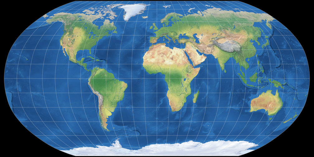
Robinson:
purpose: general use
strengths:
no major distortion
oval shape appears more like a globe than a rectangle
distortion (weaknesses):
area, shape, size, and direction are all slightly distorted
LANDSCAPE ANALYSIS
landscape analysis: defining and describing landscapes
observation and interpretation
field observation: act of physically visiting a location, place, or region and recording the information there
spatial data: all of the info that can be tied to specific locations
remote sensing: gathers information from satellites that orbit the earth or other craft above the atmosphere
aerial photography: pro images captured from planes within the atmosphere
geographer looks at:
who r the ppl migrating into this area? who’s leaving?
what r the cultures of these groups of ppl?
what effects will the changes have on the local economy?
what r the causes of ppl moving?
what types of human-environment interaction r occurring?
geospatial data
geospatial data: (quantitative/qualitative) includes all info that can be tied to a specific place
ex: where do speakers of mandarin live?
fieldwork: observing and recording info on location (in the field)
geovisualizations: 2d/3d interactive maps that can be zoomed in/out
GEOSPATIAL TECH
global positioning system (GPS)
description: gps receivers on the earths surface use the locations of multiple satellites to determine and record a receivers exact location
uses:
locating borders precisely
navigating vehicles
mapping lines (trails) or points (fire hydrants)
remote sensing:
description: the use of cameras or other sensors mounted on aircraft or satellites to collect digital images or video of the earth’s surface
uses:
determining land cover and use
monitoring environmental changes
assessing spread of spatial phenomena
monitoring the weather
geographic information systems (GIS)
description: computer system that can store, analyze, and display info from multiple digital maps/geospatial data sets
uses:
analyzing of crime data
monitoring the effects of pollution
analyzing transportation/travel time
planning urban area
smartphone and computer applications
description: location aware apps that gather, store, and use locational data from computers/other personal devices
uses:
suggesting restaurants stores, or best routes to users
contact tracing related to tracking diseases or exposure to chemicals
mapping of photos from geotags
RUBENSTEIN NOTES
CULTURE
culture: the body of customs, beliefs, material traits, and social forms that create a distinct tradition of ppl
study why the customary ideas, beliefs, and values of a people produce distinct cultural places
need to know language, religion, ethnicity
interested in production of material wealth
food, clothing, shelter
geographers divide the world into region of developed and developing countries
uneven development: increasing gap in economic conditions between region in the core (north america, europe, japan) and the periphery (africa, asia, latin america) that results from the globalization of the economy
barriers derive from unequal access to electronics and electronic services (the internet), capital to invest in new activities, and wealth to purchase goods and services
CULTURAL GLOBALIZATION AND LOCAL DIVERSITY
geographers observe increasingly uniform cultural preferences and uniform “global” landscapes of material artifacts and cultural values
globalization: a force or process (helped by tech) that involves the entire world and results in making smth worldwide in scope
time-space dilation
ex: communication (english), tech (internet and portable tech), food (fast food chains), clothing (large retailers)
transnational corp: conduct research operate facilities, and sell products in many countries,not just where it’s hqs and principal shareholders are located
ex: amazon
CONNECTION
connection: refers to the relationships among ppl and objects across the barrier of space
has three results:
assimilation: a group’s cultural features are altered (and ultimately lost) to resemble those of the dominant group)
immigrant assimilation
acculturation: the process of changes in culture that result from the meeting of two groups. the two groups retain two distinct culture features
ex: navajo and american cultures
syncretism: the combo of elements of two groups into a new cultural feature. formation of a new culture
ex: greece —> rome
diffusion: the process of by which a feature spreads across from one place to another
relocation diffusion: spread of an idea thru physical movement of ppl from one place to another
ex: human migration
expansion diffusion: spread of a feature from one place to another in an additive process
hierarchical: spread of an idea from personsor nodes of authority/power (also core to periphery)
contagious: rapid, widespread of a characteristic throughout a population (going viral)
stimulus: spread of an underlying principle even tho a characteristic itself apparently fails to diffuse (cheeseburgers aren’t eaten in india, so they changed the menu)
hearth: place from which an innovation originates