The Physical and Human Geography of Africa
Africa is the second largest continent in the world. It comprises on fifth of the world’s land mass. Home to 1.3 billion people.
Nearly 3/4’s (71%) of the population is under 25 years old.
Over half of modern human history took place in Africa with no ancestors of human beings living anywhere else.
Africa is so geographically large it could fit the United States, India, China, Argentina, New Zealand, and all of Europe could fit into this continent at one time.
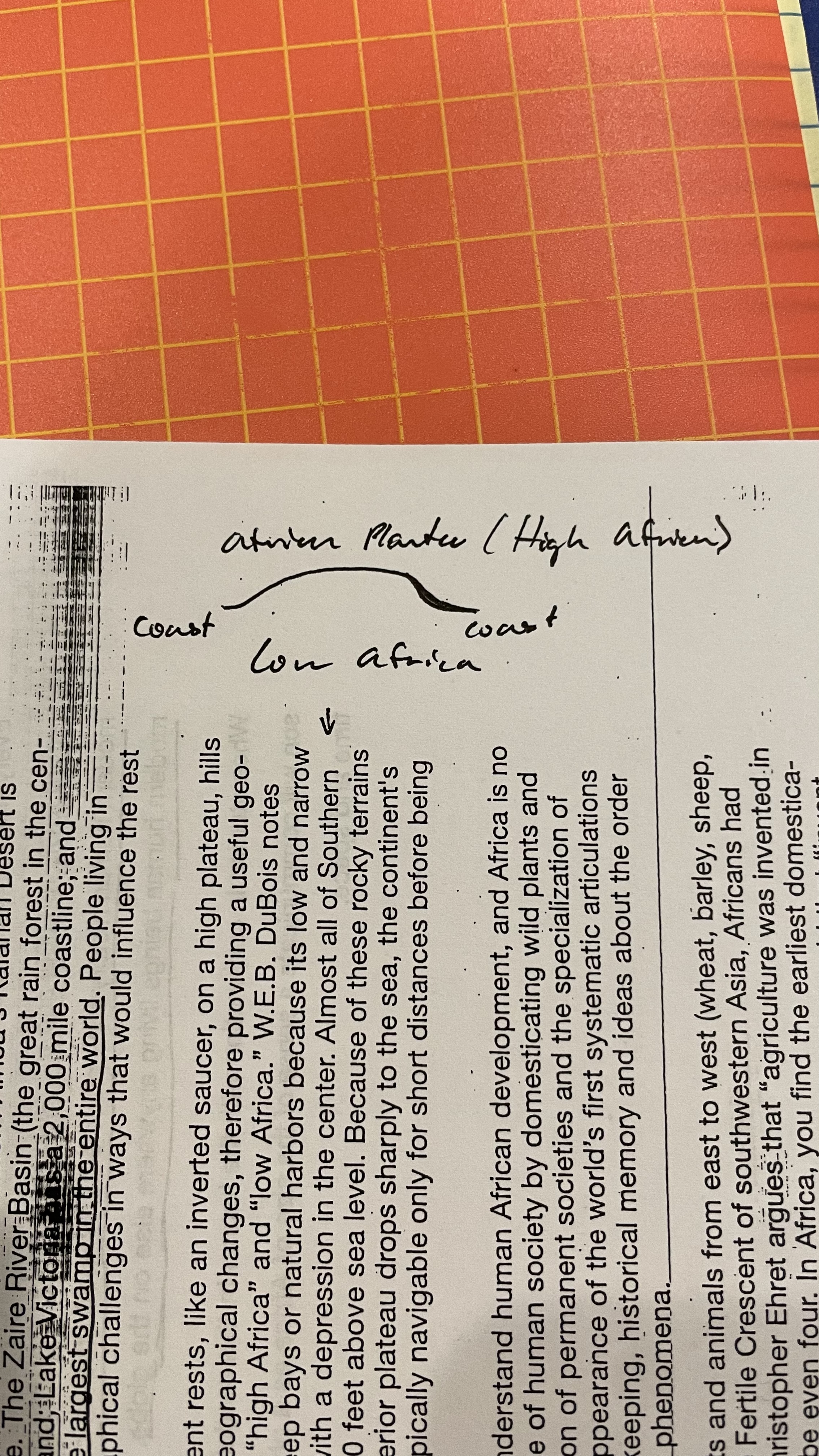
Sudan’s floating marsh the Sudd is the largest marsh in the world.
Africa’s entire 11,724,000 square miles(30,365,000 sq. km) is divided in half by the equator
There are only three seasons
Wet
Dry
Planting
History views Africa and their global descendants as victims of a sweltering environment that impeded social development rather than encouraged the emergence of major world cultures. This is false not true.
The Human Footprint Project mapped the cultural landscape of the globe(including Africa) for it’s “human influence” including population, travel routes, land use, and lights. This shows that around 40% of Africa (mostly desert or forest) is wild and/or essentially undisturbed by human beings.
There are several thousand national groups in Africa. Also called an ethnic group or tribe. National groups are distinguished by 4 basic elements
Distinct language
National memory(history)
Distinct worldview and culture (history) based on that memory and culture
Spiritual tradition or religion.
Northeast Africa
Contains massive deserts, the Sudd, mountain ranges, temperature grassland, and miles of ocean and sea coastline. Over 160 million people live in the region. It is over 2 million sq. miles big making it bigger than Europe. The most distinguishing feature is the Nile river which spans (4,132 miles)
Countries - Egypt, Sudan, South Sudan, Ethiopia, Eritrea, and some of Somalia.
Major landmarks - The Nile River (Egypt, Sudan, South Sudan, Ethiopia), Ethiopian Highlands (Ethiopia), The Sahara Desert (Egypt, Sudan and Eritrea), and Savannahs (South Sudan).
Northwest Africa
Abuts the Mediterranean Sea and Atlantic Ocean. Over 70 million people live among the 2.4 million sq. miles.
Countries - Morocco, Algeria, Libya, Mauritania, Tunisia, and Western Sahara
Major landmarks - Atlas Mountains (Morocco, Tunisia, and Algeria), Sahara Desert (Morocco, Western Sahara, Mauritania, Libya, Tunisia, and Algeria)
West Africa
Larger than the continental U.S. most populated region of Africa. The seasons consist of dry and rainy periods.
Countries - Senegal, Guinea, Liberia, Ivory Coast, Ghana, Togo, Benin, Mali, Niger, Nigeria, Chad, Burkina Faso, Guinea Bissau, Gambia, Sierra Leone, and some of Cameroon.
Major Landmarks - Niger River (Guinea, Mali, Niger, Nigeria, and Cameroon), Sahara Desert (Mali, Niger, and Chad), Savannahs (Senegal, Guinea, Guinea Bissau, Gambia, Sierra Leone, Ivory Coast, Mali, Togo, Benin, Niger, Nigeria, Chad, Burkina Fasso, and Cameroon)
Equatorial and East Africa
The middle of the continent the Equatorial region connects east and west. This region contains much of Africa’s unmatched wealth of natural resources. The Congo River Basin is the second largest tropical rainforest in the world. Within these grasslands and adjoining valleys is when the first ancestors of the human race appeared.
Countries -
Southern Africa
This region is dominated by a high, rugged plateau whose average elevation is 3,000 ft. above sea level. Most of the worlds diamonds and gold are mined from the mountains of this region.
Africa’s Islands
Madagascar is the largest island. This island has cultural roots in Africa, Indonesia, Polynesia, and Arabia (aka. multiethnic) There are 18 major ethnic groups that all share or understand a complex common language known as Malagasy.
Maruitius is nearly 1,900 sq. miles and was formed by volcanic activity.
Map