Week 1: The Earth as a Rotating & Revolving Planet
Earth is not perfectly spherical, it bulges slightly at the equator
an oblate ellipsoid
Geographic grid
Meridians of longitude divide the globe from pole to pole, parallels of latitude divide globe into rings
largest parallel is the equator
intersection of a parallel and a meridian is called an intersection
Great circles bisect the Earth
small circles are any other cut through the Earth
All meridians are great circles, all parallels but the equator are small circles
Parallels are identified from their angular distance from the equator (0-90), and either North or South
Meridians are measured how far east or west they are from the prime meridian/Greenwich meridian
measured from 0-180 and East or West
Fractions of latitude or longitude angles are called minutes (1/60th of a meridian/parallel) and seconds (1/60th of a minute)
41° 27’ 41” N translates to 41.4614° N
60 degrees latitude is 34.5 miles from the equator
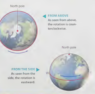
Environmental effects of the Earth’s rotation
feed plants during day
animals active during day or night
air temperature cycle
large motions in the atmosphere and oceans
gravitational pull
Map projections
earliest is mercator, scale increases at top and bottom
drawing a straight line anywhere on this map will give u a line of constant compass direction so its good for navigators
Mercator’s map can falsely make the shortest distance between two points appear much longer than the compass line joining them.
used to show many types of straight line features (wind lines, crustal features, air pressure)
polar projection centers on the pole, only one hemisphere, scale increases outward
conformal: preserving shape but changing area
equal area: shows area correctly, but shapes are distorted
winkel tripel projection
named after oswald winkel and the german word for triplet
minimizing distortion by curving the corners inward
a healthy medium
only the polar areas grow significantly
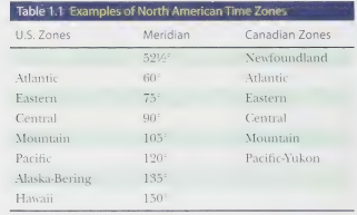
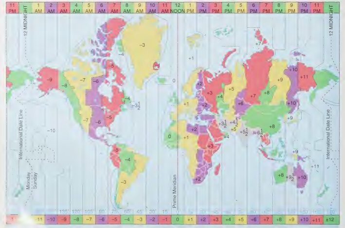
15 degrees of longitude equals one hour of time
International date line is in Greenwich at the prime meridian
Since the 1950s, the most accurate time has been kept using atomic clocks, which are based on the frequency of microwave energy emission from atoms of the element cesium cooled to near absolute zero. These very accurate clocks keep time to better than one part in | trillion. Atomic time is a universal standard that is not related to the Earth’s rotation. Civil time sources use Coordinated Universal Time (UTC), which is derived from atomic time and provides a day of 86,400 seconds (24 hours) in length to match the Earth’s mean rota- tion rate with respect to the Sun. Coordinated Universal Time is administered by the Bureau International de l Heure, located near Paris.
The Earth’s Revolution around the sun
Spring equinox: March 21st
Summer solstice (axis tilted towards the sun): June 21st
Fall Equinox: Sept 23rd
Winter solstice (axis titled away from the sun): Dec 22nd
Aphelion (farthest away from the sun): July 4th
Perihelion (closest to the sun): January 3rd
Earth’s axis is tilted 23 ½ degrees
The circle of illumination is the circle that separates the day hemisphere from the night hemisphere.
At an equinox, the circle of illumination passes through the north and south poles
The subsolar point is the single point on the Earth’s surface where the Sun is directly overhead at a particular moment.