EAS 205 - Floods
Outline
Rivers and floods
Hurricanes and coastlines
Floods in the geological record
Floods and Types of Floods
What is a Flood?
Flooding is the deadliest type of severe weather. There's probably a lot about floods and flooding you don't know.
A flood is an overflow of water that submerges land that is usually dry.
Floods are an area of study in the discipline of hydrology. They are the most common and widespread natural severe weather event, but they can also be caused by land movement (i.e. Tsunamis) and very rapid melting associated with volcanism (i.e. Jökulhlaup).
River Floods, Coastal Floods, Storm Surges, Inland Flooding and Flash Flood
Hydrologic Cycle
Water is a key requirement for life.
Water is used for industry, agriculture, infrastructure, septic tanks, etc.
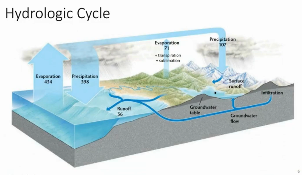
All water on Earth cycles between these various reservoirs: ocean, groundwater, atmosphere.
Water moves to the atmosphere through evaporation → earth’s surface by precipitation → move through (runoff or underground) → eventually feeds back into the ocean.
Water in the atmosphere condenses into droplets or snow depending on the temperature or humidity. That precipitation seeps into the ground through infiltration through cracks or pore spaces between particles.
A lot of this water moves immediately to the atmosphere. Some of it moves through the biosphere.
Lots of water returns to the atmosphere via transpiration.
Snowfall is sometimes converted to glaciers (runoff or through sublimation in the atmosphere).
North Saskatchewan River Average of 238 m³/s.
On a global scale, the hydrologic cycle is relatively in balance. However, on a local scale, variations in climate means that these can get out of whack.
They can result in things like droughts and flooding.
Stream:
A body of flowing water confined to a channel
River:
the major branch of a stream system
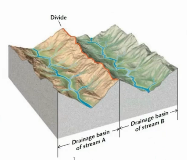
Drainage basin:
the region from which a stream draws its water supply; drainage basins are defined topographically by a term called divides.
A divide is a ridge or a high ground along which rainfall runs off form one side or to the other.
Discharge:
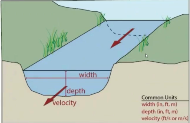
the volume of water that passes a given point in a given time through a channel of a certain width and depth, measured in m³/s.
Discharge = Width × Depth × Average Flow Velocity.
Stream - Types of Water Flow:
There are two main types:
Laminar → straight or gently curved streamlines run parallel without mixing or crossing.
Turbulent → streamlines mix, cross, and form swirls and eddies.
Whether flow is laminar or turbulent depends on three factors.
Velocity, geometry (of the river or wherever its flowing, particularly depth), and viscosity.
The lower the viscosity, the higher chance its going to be turbulent.
Sediment load:
all the material temporarily or permanently suspended in the flow.
Capacity:
total sediment load carried by a flow.
Capacity is closely related to discharge, meaning that the faster the stream flows, the more water is present, the more and also larger material that can be moved, the more energy it has.
The more energy it has, the more likely it is to move larger grains.
More energy = more capacity to transport something.
Competence:
a flow's ability to carry material of a given particle size.
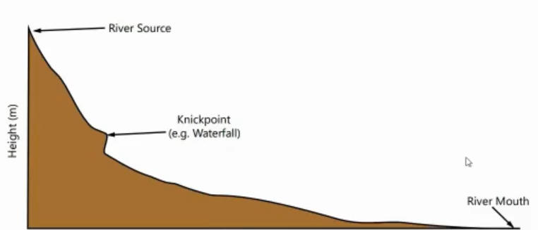
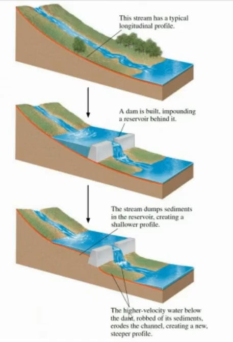
Gradient:
the steepness of a stream's channel.
Base level:
the lowest elevation to which a stream can flow.
For a river that flows to the ocean, the base level is the sea level.
Graded stream:
a stream where the profile has become stable over a period of time and experiences neither erosion or sedimentation over the course of the stream and is said to be at equilibrium
Stream Morphology
Two different stream types:
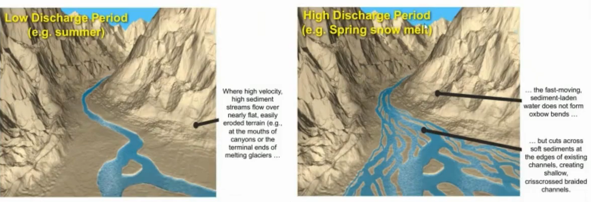
Braided Stream → Constantly breaking apart and coming together. Typically steep in terms of a gradient, they have a lot of sediment. They have high sediment loads with frequent changes in discharge.
Meandering Stream → Occur on more gentle gradients. They generally erode unconsolidated sediments that have weak bedrock. They carry very fine sediments and their path can shift significantly with erosion and deposition.
Rio Cauto, Cuba → meandering river.
Rakaia River, New Zealand → braided river.
Low Discharge Period:
Where high velocity, high sediment streams flow over nearly flat, easily eroded terrain (i.e at the mouths of canyons or the terminal ends of melting glaciers).
Low discharge summer.
High Discharge Period:
The fast-moving sediment-laden water does not oxbow bends but cuts across soft sediments at the edges of existing channels, creating shallow, crisscrossed braided channels.
Spring melt time.
Meandering Rivers:
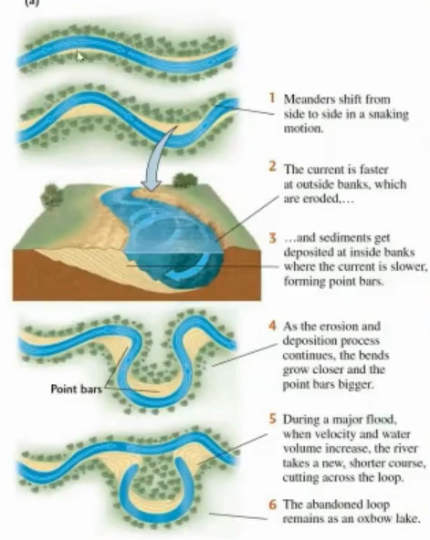
Meanders shift from side to side in a snaking motion.
The currents faster at outside banks, which are eroded…
and sediments get deposited at inside banks where the current is slower, forming point bars.
As the erosion and deposition process continues, the bends grow closer and the point bars bigger.
During a major flood, when velocity and water volume increase, the river takes a new, shorter course, cutting across the loop.
The abandoned loop remains as an oxbow lake.
Floodplain:
a flat area about level with the top of the channel on either side of the channel that floods when the stream spills over its banks.
This can create a natural levee.
Good for agriculture.
Natural levees:
ridges of coarse material that confine the stream within its banks between floods, even when water levels are high.
If a stream floods continuously…:
It can eventually build up natural levees, which can further contain the channel.
The stream can actually run at a height that’s higher than the floodplain, and it can actually prevent flooding from occurring.
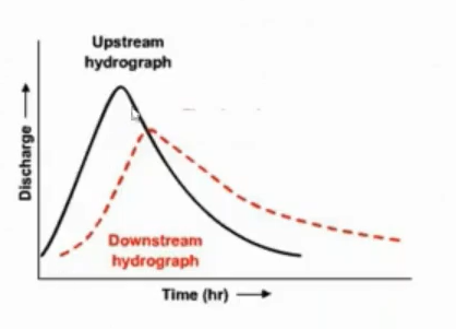
Hydrograph:
a plot of stream discharge at a point over time.
They record fluctuations in discharge or stream height.
Base flow → bare minimum of the river.
Spring thaw meltwater → causes a spike in the graph. Water level and discharge levels increase and peaks.
Rainy season → a bigger spike is present (usually late summer), resulting in large spikes during the rainy season.
Helps with interpreting discharge patterns and the particular drainage of a particular drainage basin.
Useful as it can be used to predict flood events and implement flood prevention measures.
Drought in Alberta
Flooding Rivers
Input > output → will cause a flood.
Many different events can lead to input being greater than output (hence flood).
Smaller flood are generally more frequent than bigger floods (like how smaller earthquakes are bigger than larger earthquakes).
Calgary 2013 Flood
Cost about 6 billion dollars in damage.
Five people died and thousands of people were displaced because of the flood.
In June 2013, Southern Alberta got a lot of torrential rains in the Rockies.
In Calgary, they recorded 68 millimeters of rain within 48 hours.
Burns Creek got more than 345mm of rain and Canmore got 200mm of rain → 10x more amount of rainfall that they got in 2 days.
There were many mudslides which closed parts of the trans-Canada highway.
About a dozen or so communities were affected by the state of emergency.
Edmonton Flood, 1915
The North Saskatchewan River rose 10 meters in 3 days.
That is the highest record that we know of.
The city lost power, the pumping plant closed, there was no drinking water, 2,000 people were displaced, 50 buildings were destroyed, and over 700 homes were fully submerged in water.
Flood Characteristics
Stage: the elevation of the water
Crest: maximum stage → the highest the river can actually get to.
Flood Stage: Where the stream exceeds the height of the banks.
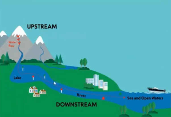
Upstream flood: occurs in a small, localized upper part of the basin
Downstream flood: occurs in a larger, lower part of a drainage basin
Flash flood: a type of upstream flood characterized by a rapid rise in stream stage
Hydrographs: Upstream vs Downstream
Stormwater Management Pond (SWM)
Also called “swim pond” but they’re not meant to swim in.
Play an important role in reducing flood risk.
During heavy rainfall, runoff go into SWM ponds.
These ponds prevent it from overwhelming nearby streams and rivers. They temporarily store the water and releases it slowly.
It helps reduce downstream flooding and erosion.
Flooding:
Rate of surface runoff is influenced by:
Ground cover → different rates of water infiltration into the ground depends on where they are. The rate of infiltration varies depending on if its in soil, rocks, pavement, etc.
Topography → the steepness of the terrain. A shallower slope will allow more time for infiltration. This can also cause water pooling.
Presence of vegetation → Plants provide a physical barrier than can decrease the velocity of water while moving on the surface + increases soil infiltration because plants absorb water.
Climate → Determines the preciosity of storms in the area. In colder climates, frozen soil can impact runoff and affect spring runoff (and thereby increase the chance of flooding).
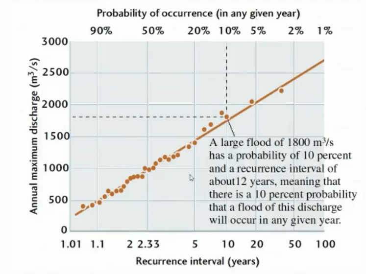
Flood Frequency Curve
Or recurrence interval
R = (N + 1) / M
Where:
R = recurrence interval
N = number of years
M = ranking of annual maxima
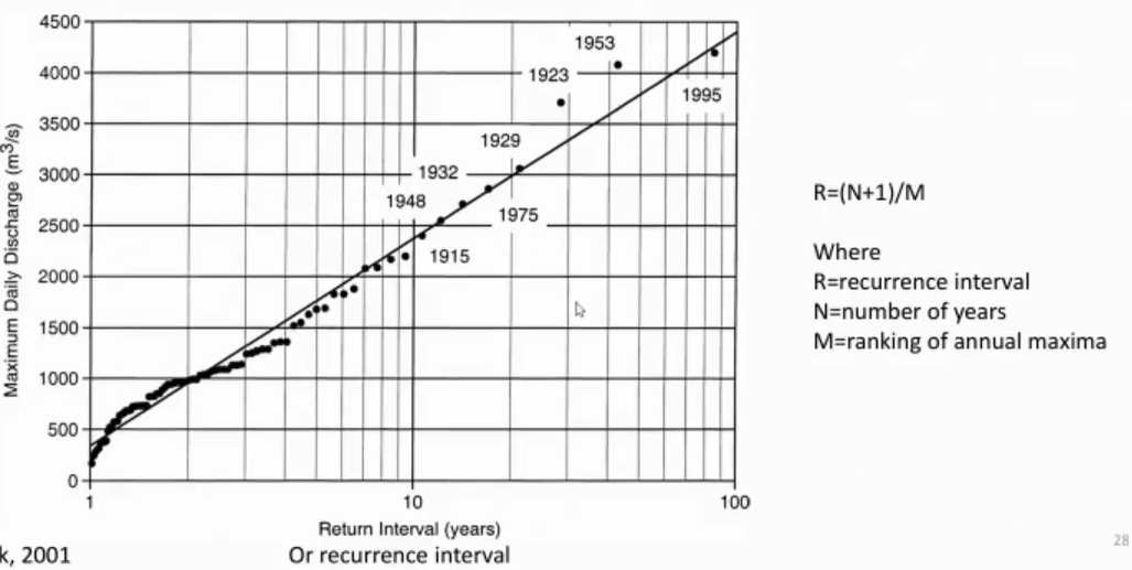
Recurrence Interval of Floods:
The recurrence interval of floods of a certain discharge depends on basically three things:
Climate of the region.
Width of the floodplain.
The size of the channel.
Increased risk
Development in a floodplain → building on a floodplain increases the risk of flooding.
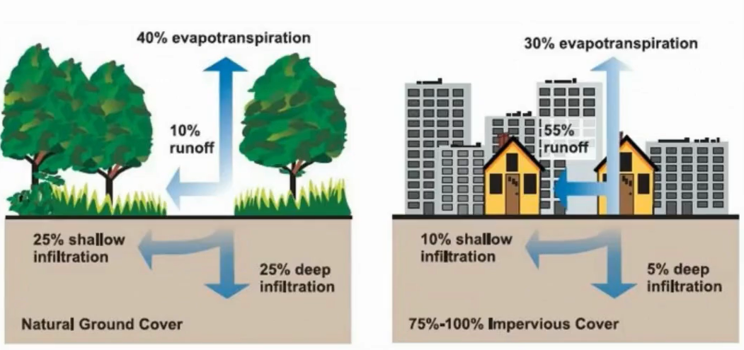
Adding asphalt (or concrete) will decrease infiltration and affect the floodplain
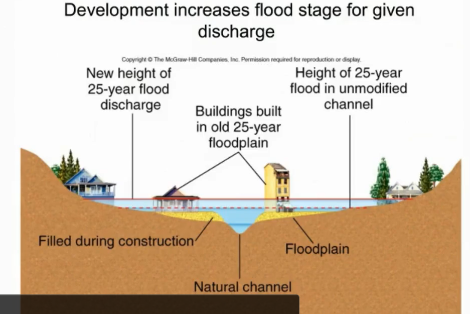
Buildings may reduce area on the floodplain which can potentially raise stream heights.
You can expand the flood plain by developing on it → this reduces the amount of water that a flat plane can handle. With more structures present in the floodplain, there will be more water because the volume will stay the same. But now it has less area, so it’s going to have to spread out to accommodate.
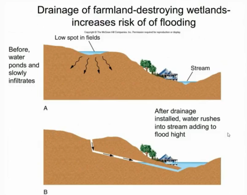
The addition of storm drains can return water to streams in a storm and increase the stream height again.
The natural vegetation is lost.
Deforestation.
Climate change – more later.
Development Increases Flood Stage for Given Discharge:
Any given year, there’s a 1 in 25 change of flooding.
Now that we’ve build on this floodplain and filled in parts of the floodplain during construction, the volume has changed.
From that, the height or stage of a flood of the same probability is also affected.
The buildings that were not previously affected that aren’t on the floodplain will now be affected because of development.
Goes from dashed line (without development) to higher levels (red undashed line, with development).
Flood Hazard Mitigation
Restrictive zoning → not building some buildings in certain places. Doesn’t quite work if there’s already a neighborhood present there.
Retention pond → an artificial pond with vegetation around it. It’s meant to manage storm water runoff and protect against flooding & control erosion from flooding.
Common in newer suburbs.
Diversion channel → usually has a canal from a stream or a lake. The water flow is controlled through a water intake. It gives extra water somewhere to go.
If discharge is higher, then the stream or body of water can handle the lake, leading to a diversion of water.
Channelization → A process where you widen or deepen a river manually. This is to increase the flow capacity and certain sections of the river. During a flood, the water can still move through the channel, but the water is less likely to spill over the banks. Less water will go into the floodplain or you can avoid the floodplain altogether, depending on what you’re doing. It also provides erosion control and can fix damage caused by floods salting up a river. Too much silt and fine particles can block the stream and cause flooding. It can have negative impacts because it affects the downstream area where channelization hasn’t been done.
Levees → They’re raised structures and can act as a barrier between two areas. They can be made from concrete or excavated land that has been built into a hill at the margin of the river. It also absorbs excess water during a flood.
Flood control dams and reservoirs → They construct a barrier across rivers or streams to detain water and create a lake or a reservoir. Can be used to produce electricity. They divert and control the flow of water volume in streams. When they are anticipating high levels of precipitation, the operators will lower the water level in the reservoir by introducing water into a spillway to prepare and make room for incoming water. This can also protect downstream areas as well.
Spillways → when the water becomes too high in the reservoir they have controlled areas that you can introduce water into.
Not building on floodplains
Coastlines
Many different things affect the coastline → Tectonic settings, materials at the shore, what the shoreline is made out of, what’s the energy like when the water strikes the coastline?
There are two different types of coastlines:
Active margin (BC) → associated with plate tectonics and cliffs.
Passive margin (PEI) → far from any active plates and broad shore and offshore beaches.
However, the cliff/beach thing for active and passive margins are not a hard and fast rule.
Sea Level
Also affects coastlines.
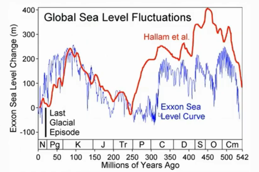
Sea level has changed a whole lot over geologic time.
With sea level changes, you can see continental changes. They can uplift and produce emergent coastlines, large rivers can drain water and sediment form the continental terriers and form large deltas and adjacent oceans, or loading of the crust which can produce submergent coastlines.
Eustatic Sea Level:
Distance from the center of the earth to the sea surface.
Relative Sea Level:
Sea level observed with respect to land.
Emergent Coastlines:
These are the results of tectonic uplift of the land surface or they can be a of result in a fall of sea level.
The west coast of North America is an emergent coast as well as parts of Scandinavia due to the removal of glacial ice during the last ice age.
Greenland
Brazil
Submergent Coasts
They are the opposite to emergent coastlines.
Their coasts have been flooded permanently because of a relative rise in ocean water.
This is from either a eustatic sea level rise (1) or the land sinking (2).
Drowned valleys are a common feature of these coasts.
Chesapeake Bay, USA
Sydney Harbour, Australia
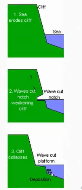
Wave-cut platform
Can also be called a wave-cut terrace.
This is caused by changes in relative sea level.
A narrow flat area at the base of a cliff that’s been eroded by waves.
Given enough time, it can also form caves.
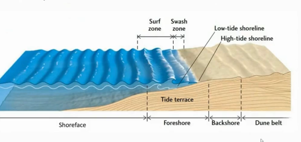
Anatomy of a Beach
A beach is a type of coast. It is a shoreline environment made up of sand or pebbles.
The shape can change day-to-day, season to season, etc.
Waves and tides can affect the beach, and they can extend it by depositing sand or they can erode things and carry sand away.
Foreshore → it is where low tide (the base) and high tide (the height of it) fit in.
Broken into zones.
Surf Zone: The zone where waves break as the ocean gets shallower moving into land.
Swash Zone: Where waves bore up in the beach.
Shoreface.
Backshore → The high tide back and continues onwards.
Dune belt → can go further out of the backshore. This is where sand dunes, natural levees, etc occur.
Waves and Tides - Tides
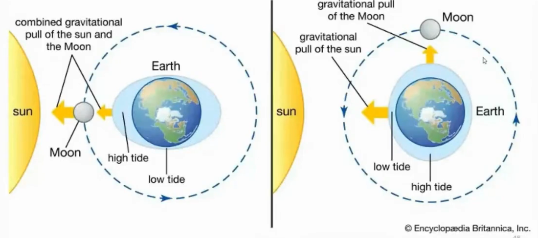
Tides are the rise and fall of sea level. They are caused by a combined effect of gravitational forces exerted on the earth by the moon (and the sun to a smaller extent).
As the earth is rotating, it is actually rotating through a bulge created by the rotation of the earth, which is then pulled by the sun and/or the moon.
Some places have equal high and low tides → called semi-diurnal tides.
Some places have one high and one low each day (differences can vary depending on location).
Flooding tide: As the tide rises, the water flows towards the shore. Then, it moves into coastal marshes and upstream.
Ebb Tide: Then the tide begins to recede after high tide and begins to fall. It exposes the low coastlines then.
Intertidal zone/flat → can be bigger or smaller depending on location.
Waves and Tides - Waves:
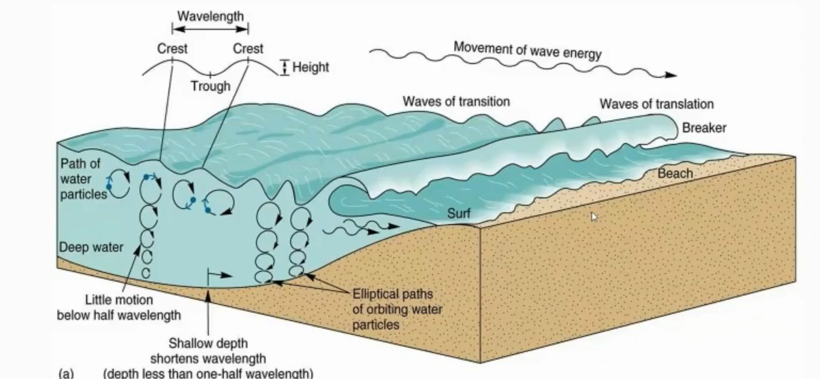
Created by wind.
Waves propagate. When the move, the water involved moves in a circular motion in place.
Wavelength becomes negligible at a certain point → this is called wave base.
A wave is the distance from the crest of one wave to the crest of an adjacent wave.
If a wave is 2m, then the wave energy is 4.
Waves also depend on local conditions (i.e. how steep the shoreline is).
Longshore Drift
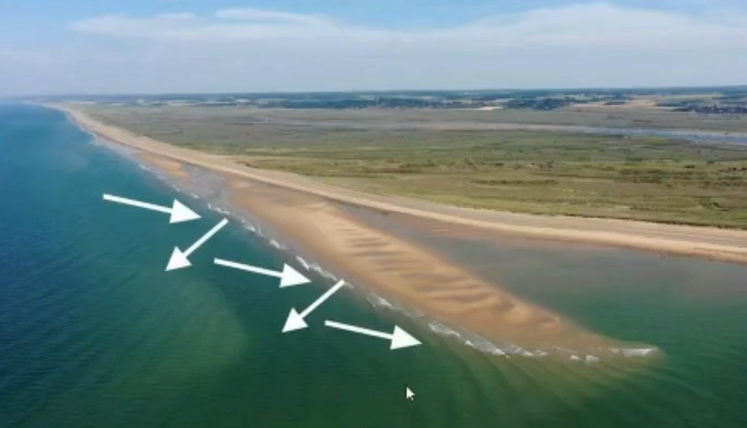
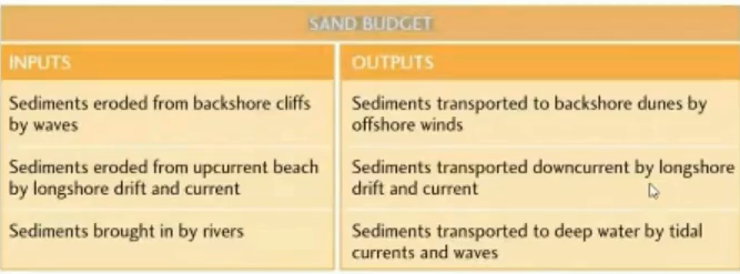
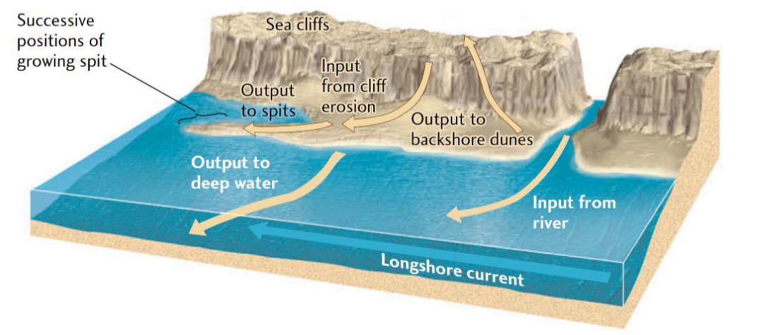
This occurs when a wave hits the coast an an angle, along with the wind, which squeezes the water along the coast and generates a current which transports sediment parallel to the shoreline. Over time, longshore currents can remove sand from one part of the beach and deposit it elsewhere on the beach downcurrent.
breakwater
jetty
Sea Level Rising:
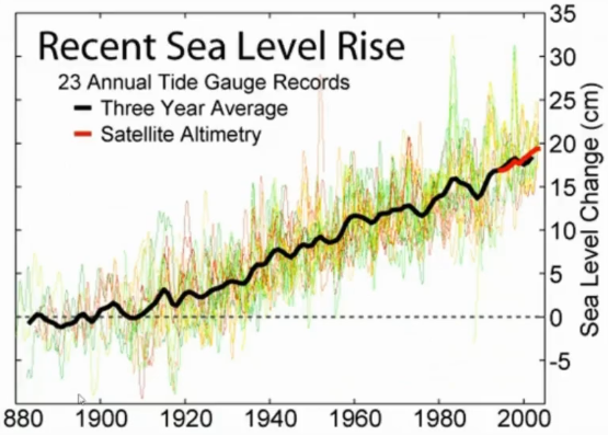
Causes coastal erosion and requires stabilization.
This can be bringing in sand (that’s been taken away by currents).
Even the artificial berms have their own erosion and deposition problems associated with them.
i.e. Breakwaters and jettys. Although they have their own issues.
Breakwater:
Used to break the water when the sea level rises.
Reduces the energy flow.
Jetty:
Reduces energy flow.
Coastal Flooding
Coastal flooding storms are big environmental surges that are associated with natural disasters.
Occurs from unusually high tides or storm surges. Tsunamis can also do this.
King tides (the highest tides possible due to gravitational pull).
Storm surges are episodes of higher sea levels. It’s caused by really strong winds and sometimes made worse by low air pressure → sucks the sea level upwards. The strong wind drives water towards the shore, increases sea level over a short period of time, the longer the wind goes, the greater the surge effect can be. If a storm surge coincides with the high tide it can cause a lot of damage.
These are often caused by tropical storms (i.e hurricanes/Typhoons/Cyclones).
The name depends on the location of where it originates.
Hurricanes, Tropical Cyclones, and Typhoons
Hurricanes originate in the Atlantic Ocean (technically the Northeastern Pacific Ocean).
Typhoons occur in the Northwestern Pacific Ocean.
A cyclone occurs in the South Pacific Ocean or the Indian Ocean.
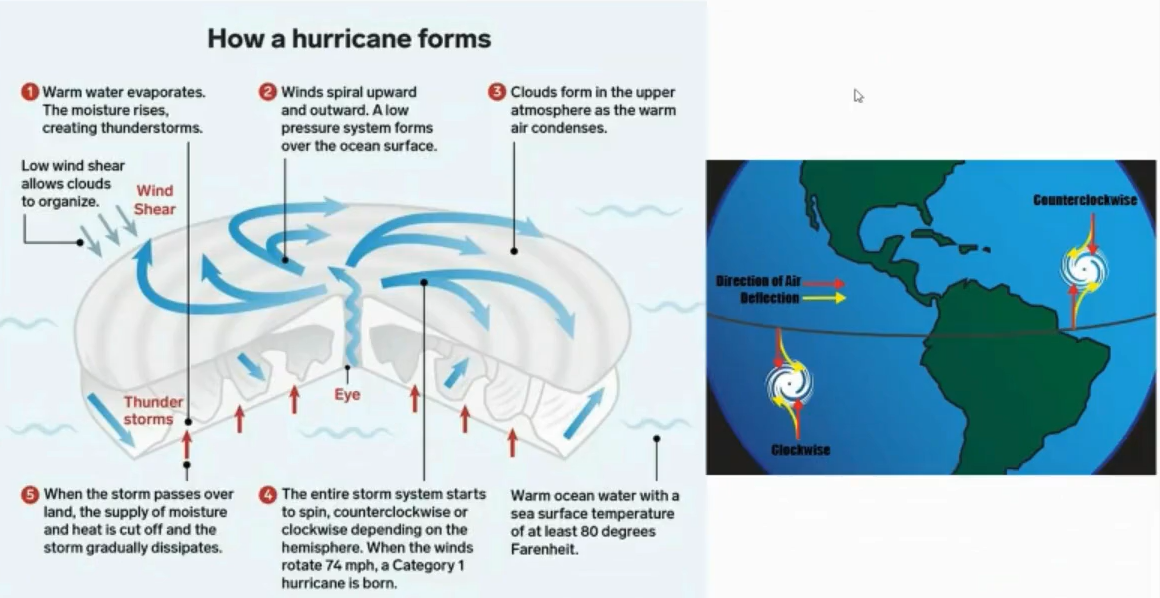
All of them (hurricane, typhoons, and cyclones) forms through wind and heat.
In an area of low pressure (like an inter-tropical convergence zone) → near the equator.
Air is heated over the ocean and it rises. This creates thunderstorms. Storms can either dissipate or group together.
If they do group together, they can start to spin due to the Coriolis effect (caused by the spinning of the earth).
The Coriolis effect is why hurricanes, typhoons, cyclones spin clockwise in the southern hemisphere but counterclockwise in the northern hemisphere.
Sea level temps are around 27 degrees Celsius and there has to be low vertical shear wind surrounding the storm system.
Windshear is the different between wind speed over a short distance.
You need enough Coriolis force and high humidity to cause this.
They form over the ocean (that’s where they come stronger). They become weaker as they go over land.
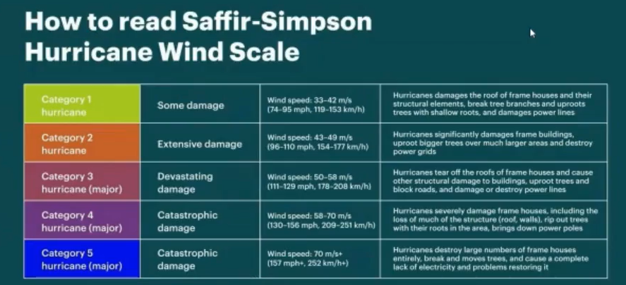
There are five categories of strength → category 1 being the weakest and category 5 being the strongest.
Very dangerous in coastal areas.
Saffir-Simpson Wind Scale:
Used in the western hemisphere.
It categorizes them based on sustained wind speed.
Sustained wind speed is measured at a distance of 10m for 10mins, and then it takes the average of that.
At less than 17m/s → tropical depression.
Between 18m/s to 32m/s → tropical storm.
Mitigation:
Non-structural mechanisms: Zoning and regulations.
Engineering (e.g. flood barriers, seawalls, levees).
Natural defenses (e.g. mangroves, salt marshes, sand dunes).
The issue for natural options is that in many coastal areas, the natural defenses have been removed for agricultural purposes.
Mangroves:
They trap sediment which also guards against erosion.
Catastrophism or Uniformitarianism
Catastrophism
Suggested that features seen on the surface of the earth (like mountains) were formed by large or abrupt changes or catastrophic events.
Opponents to Uniformitarianism, the Opposite of Catastrophism:
When discussing past climates:
Doesn’t speak of no analog changes.
There’s no massive, instantaneous growth of (mountains occurring/rivers that are forming/continents aren’t moving) that are occurring in the modern day.
That would suggest that the rate of these things occur a much shorter period of time in the past than they do now.
Uniformitarianism (Geology):
The present is the key to the past.
Prior to 1830, this was not the prevailing theory. Catastrophism is the main theory subscribed to prior to this time.
Gradualism was good for geology.
A slow process that shaped the earth and the geologic record.
Challenges to Catastrophism:
James Hutton (Scottish farmer and naturalist) and Charles Lyle challenged this theory.
Hutton believed that natural processes (like mountain building and erosion) occurred slowly over time through geologic forces that have been active since earth first formed.
The Appalachian mountains have been eroding longer than Everest and the Rockies have been building up.
"I could conceive of no geological process of erosion to make this topography except huge, violent rivers of glacial meltwater... It was a debacle, which swept the Columbia Plateau." - J Harlen Bretz
His work showed a massive flooding event that happened as a result of the end of the last ice age.
Caused a huge controversy when he said this. At this point, the prevailing theory was uniformitarianism (its around 1920).
As time went on his ideas were eventually accepted.
Pre-scientific myth about the origin of the Mediterranean Sea
"In his Historia Naturalis (~77 AD), Pliny the Elder reports on a legend popular among the inhabitants of southern Iberia, telling how the Mediterranean Sea was born. According to this myth, the Mediterranean Sea was deserted and cut-off from the Ocean, and it was Hercules who dug an inlet with his sword between Jebel-el-Mina (Africa) and the rock of Gibraltar (Europe). This allowed the ocean to flow into the Mediterranean Basin, where 'it was before excluded', thus 'changing the face of Nature'."
Pre-scientific myth about the origin of the Mediterranean Sea
The Pillars of Hercules at Ceuta is a statue in the Spanish town of Ceuta, a Spanish enclave in the extreme north of the African continent.
Pre-scientific myth about the origin of the Mediterranean Sea
"Even after Steno and Lyell set the principles of Geology and the Messinian stage was recognized as a pan-Mediterranean evaporitic phase in the late nineteenth century by Mayer-Eymar in 1867 (Selli, 1960), nobody linked it with Pliny's accounts, perhaps because their catastrophic nature was at odds with the principle of gradualism, a scientific pillar deeply rooted in the birth of Geology."
Pre-scientific myth about the origin of the Mediterranean Sea
"Gradualism was eventually challenged when Bretz (1925) and Pardee (1942) set the floor for a paradigm change in geology recognizing outburst floods of unprecedented magnitude as the main agent for landscape formation in the Scablands (Washington state, NW USA) during the Pleistocene. Bretz and Pardee described flood deposits, giant erosion coulees and giant 'ripples' that are today widely accepted to be the result of the catastrophic emptying of Lake Missoula in Montana."
Mediterranean Sea during Messinian Time
The Mediterranean Sea became disconnected from the world's oceans and mostly desiccated by evaporation about 5.6 million years ago during the Messinian salinity crisis.
Geologists inspecting the Realmonte Mine in Sicily, where Messinian salt is mined.
The Atlantic waters found a way through the present Gibraltar Strait and rapidly refilled the Mediterranean 5.33 million years ago in an event known as the Zanclean flood.
Order of Events
Red arrows indicate the average motion of Africa relative to Eurasia since 5.3 million years ago.
Time of maximum erosion rate at the Strait of Gibraltar;
The western basin level reaches the Sicily Sill.
The eastern basin level reaches the Sicily Sill.
The Mediterranean is filled to the normal oceanic level.
Messinian to Zanclean Mediterranean
Evidence for an erosion water flow and incision in the early stages of flooding imply discharges of about 10⁸ m³ s⁻¹ (three orders of magnitude larger than the present Amazon River) and incision rates above 0.4 m per day across the Gibraltar Strait.
Map showing the depth to the base of Pliocene, including the Messinian Erosion surface (MES) and the erosion channel (red line) resulting from the Zanclean megaflood and the main flood paths (orange line).
Evidence for an erosion water flow and incision in the early stages of flooding imply discharges of about 10⁸ m³ s⁻¹ (three orders of magnitude larger than the present Amazon River) and incision rates above 0.4 m per day across the Gibraltar Strait.
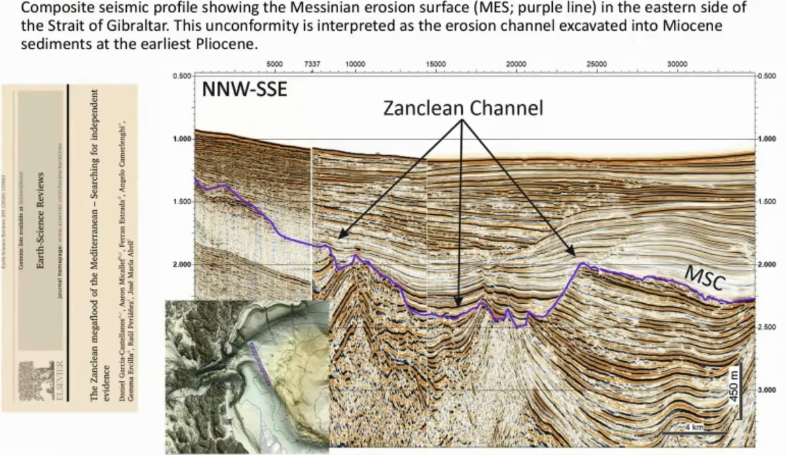
Composite seismic profile showing the Messinian erosion surface (MES; purple line) in the eastern side of the Strait of Gibraltar. This unconformity is interpreted as the erosion channel excavated into Miocene sediments at the earliest Pliocene.
Zanclean = Associated with flood of the Mediterranean.
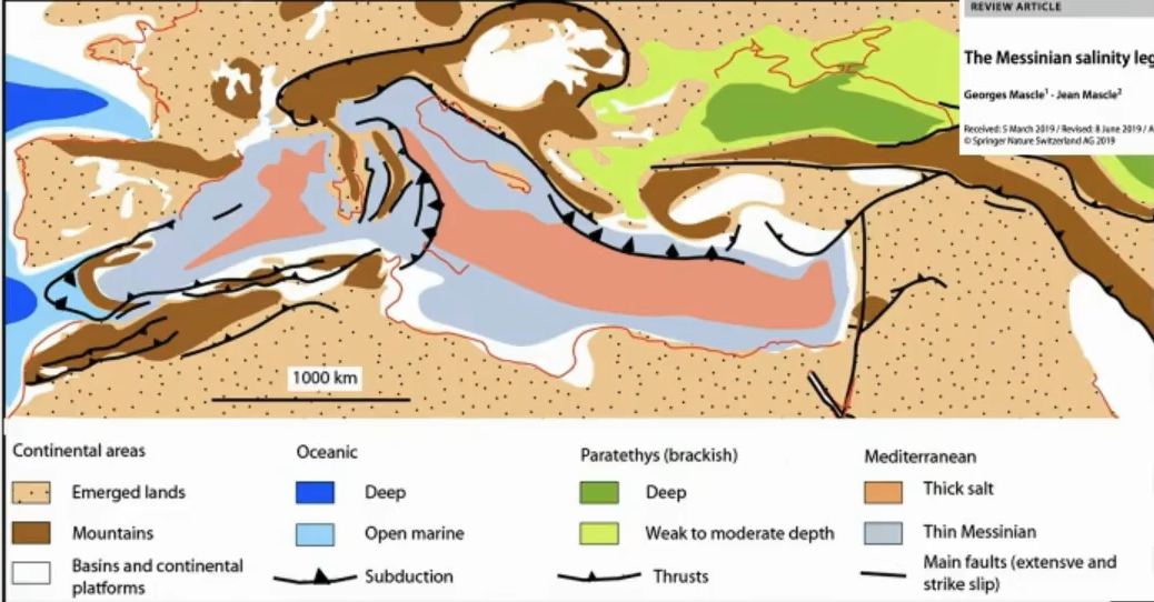
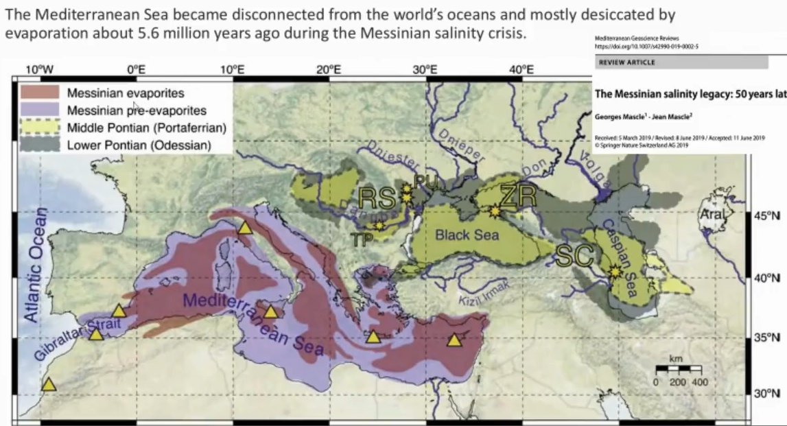
Order of Events
Time of maximum erosion rate at the Strait of Gibraltar.
The western basin level reaches the Sicily Sill.
The eastern basin level reaches the Sicily Sill.
The Mediterranean is filled to the normal oceanic level.
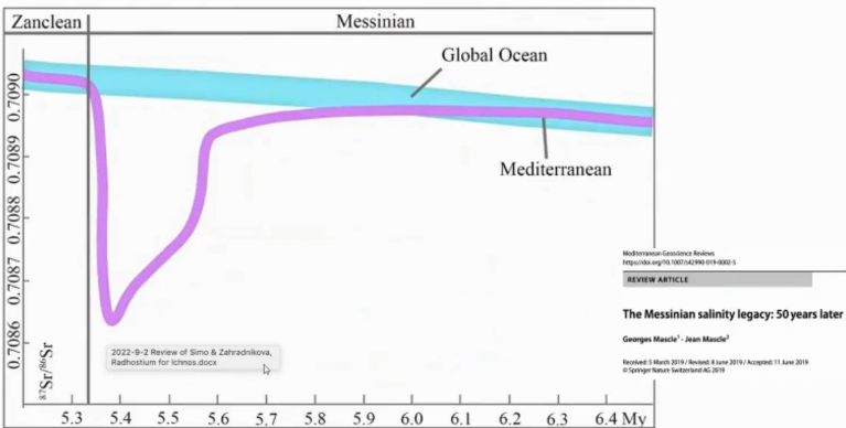
Strontium Isotopes:
Isotopes are a paleoclimate proxy.
Dips during the crisis.
The ocean stayed more or less the same, but the Mediterranean was cut off from the global ocean and then reconnects during the Zanclean.
This identified sedimentary body is the largest known megaflood deposit on Earth
Evidence for an erosion water flow and incision in the early stages of flooding imply discharges of about 108m3s-1 (three orders of magnitude larger than the amazon river) and incision rates above 0.4m per day across the Gibraltar Strait.
10m of water per day.
~40,000,000,000 m³ of transported sediment (40 billion).
For perspective, a rail boxcar has a volume of about 170 m³.
So, the amount of sediment moved by the water channel would have required 235,294,100 boxcars.
Since boxcars are 18 m long, so the train required would be 4.2 million km long.
That train would wrap around the Earth 106 times.
VIDEO
The Unbelievable Story of Earth’s Most Epic Flood
Main Points:
Glacial Lake Missoula: About 15,000 years ago, a massive ice sheet formed a dam, creating a lake in Montana that held more water than Lake Ontario and Lake Erie combined (2:58-3:10).
Catastrophic Failure: The ice dam, standing 2,000 feet tall, repeatedly broke, releasing water at a rate equivalent to 10 times the flow of all rivers on Earth, causing massive erosion in just days (4:15-5:05).
Geologic Fingerprints: The flood left behind dramatic features like Dry Falls, which was once the world's largest waterfall, and giant ripples in the landscape (5:20-6:55).
Pre-broken Bedrock: The region’s basalt columns, formed by ancient lava flows, were already fractured, making them easy for the floodwaters to sweep away (8:15-9:00).
Scientific Shift: Geologist J. Harlen Bretz faced opposition for his theory of "catastrophism," which challenged the traditional belief that geological changes only occur slowly over long periods (10:55-11:35).
Vocabulary:
Channeled Scablands: An arid, rugged landscape in Washington scarred by ancient, violent floods (6:18).
Jökulhlaup: An Icelandic term for a sudden, catastrophic glacial outburst flood (5:08).
Erratics: Large boulders carried by glaciers or icebergs and dropped in locations far from their origin (7:48).
Rhythmites: Striped sedimentary deposits that provide evidence of repeated flood events (10:05).
Uniformitarianism: The theory that Earth’s surface was shaped by slow, steady processes over immense time (11:22).
Catastrophism: The theory that rapid, violent, and cataclysmic events have significantly shaped Earth's geology (11:29).