Our natural world (OCR)
I. Global Hazards
1.1 How can weather be hazardous?
Causes of Extreme Weathers
Global Circulation System: A complex pattern of atmospheric movements that distribute heat and moisture around the Earth, significantly influencing the planet's climate and weather patterns.
Heat over the surface of the Earth affects the water cycle, (formation of clouds and precipitation events).
Each hemisphere has three cells in which air circulates through the entire depth of the troposphere namely;
Hadley Cell: (Largest cell) the low-latitude overturning circulations that have air rising at the equator and air sinking at roughly 30° latitude.
It is where trade winds blow towards the equator and rise near the equator, forming a band of thunderstorms called the Inter-Tropical Convergence Zone (ITCZ).
Ferrel Cell: (Middle cells) its circulation are complicated by a return flow of air at high altitudes towards the tropics, where it joins sinking air from the Hadley cell.
Moves in the opposite direction to the two other cells (Hadley Cell and Polar Cell) in which they act like a gear.
Polar Cell: (Smallest and weakest cell) which extends from between 60 and 70 degrees north and south.
Air sinks over the highest latitudes and flows out towards the lower latitudes at the surface.
Effects of High and Low-Pressure Belts in Creating Climatic Zones
High Pressure: a condition of the atmosphere in which the pressure is above average.
Systems that are associated with clear skies and dry, hot weather.
Air becomes denser and falls to the ground (leading to high pressure) when it cools.
Clouds evaporate as the cool air warms (when it reaches the earth’s surface).
Reduced moisture (when air reaches subtropics) causes heavy rain at the Equator.
Low Pressure: characterized by or exhibiting atmospheric pressure that is below average.
Raises heated air, which then cools and condenses to form clouds.
Causes precipitation (when rain, sleet, or snow falls due to moisture)
Minimal changes in temperature due to the cloud covering and trapping solar radiations.
Association of Wind, Temperature, and Precipitation in Extreme Weather Conditions
Extremes in weather conditions – wind, temperature, and precipitation – are all interconnected and can vary greatly between contrasting countries due to factors like geography, latitude, and proximity to oceans.
Temperature and Precipitation
Colder countries tend to have lower average precipitation.
Colder air holds less moisture, so there's less water vapor available to condense and fall as rain or snow. (Places like Siberia or Canada experience this)
Warmer countries (especially those near the equator) often have higher precipitation.
Warm air holds more moisture, leading to heavier rainfall. (Countries like Brazil or Indonesia)
Wind and Precipitation
High precipitation events are often accompanied by strong winds.
Wind can be caused by pressure differences between areas of high and low pressure. During storms and heavy rainfall, these pressure differences are more pronounced, leading to stronger winds.
Geography's Influence
Mountain ranges can block wind patterns, creating rain shadows on one side and wetter areas on the other. (ex. The Himalayas blocking monsoons in South Asia)
Large bodies of water have moderate temperatures, influencing extremes.
Countries near oceans tend to have milder temperature fluctuations than continental interiors.
Example of Contrasting Countries
Take note that these are general trends and that weather patterns are influenced by various factors.
Canada vs. Mexico
Canada’s high latitude experiences frigid winters with low precipitation.
Mexico being closer to the equator, has hot, dry summers and mild, wet winters.
Iceland vs. Australia
Iceland - an island nation, has strong winds and cool temperatures year-round due to its proximity to the North Atlantic Ocean.
Australia - a continent with a vast interior, experiences scorching summers and mild winters with pockets of high precipitation.
Distribution and Frequency of Tropical Storms and Droughts
The distribution and frequency of tropical storms and droughts are influenced by complex climate patterns, but trends suggest a potential increase in the intensity of these events due to global warming.
Tropical Storms
Distribution: These storms thrive in warm ocean waters (typically above 26°C or 80°F) near the equator. The major breeding grounds are:
Atlantic Ocean, Caribbean Sea, and Gulf of Mexico (June-November peak)
Eastern Pacific Ocean (May-November peak)
Western North Pacific Ocean (May-December peak)
Northern Indian Ocean (April-May and October-November peaks)
South Indian Ocean (November-April peak)
Frequency: The global number of tropical storms formed each year varies, but averages around 80-100.
The specific regions experience seasonal variations due to factors like sea surface temperatures and wind patterns.
Changes over Time
No clear increase in total storms, but a possible shift towards more intense storms with stronger winds and heavier rainfall due to warmer ocean temperatures.
Sea level rise can lead to higher storm surges causing greater coastal flooding.
Droughts
Distribution: Droughts can occur anywhere globally, but some areas are more prone due to:
Subtropical regions with high pressure systems limiting rainfall (e.g., Mediterranean, parts of Africa)
Rain shadow areas behind mountain ranges (e.g., eastern slopes of the Rockies)
Areas with strong El Niño events (can disrupt usual rainfall patterns)
Frequency: Droughts can last weeks, months, or even years. Their frequency varies depending on the region's climate.
Some areas experience regular seasonal droughts, while others might have them occasionally.
Changes over Time
Studies suggest an increase in drought frequency and intensity in some regions due to rising temperatures and changes in precipitation patterns.
Warmer air increases evaporation, drying out the soil and worsening droughts.
Causes of Extreme Weather Conditions Associated with Tropical Storm
Warm Ocean Temperatures |
|
|---|---|
Low Atmospheric Pressure |
|
Coriolis Effect |
|
Minimal Wind Shear |
|
Moisture Availability |
|
El Niño and La Nina
El Niño and La Niña are natural climate patterns, but climate change may be intensifying their effects.
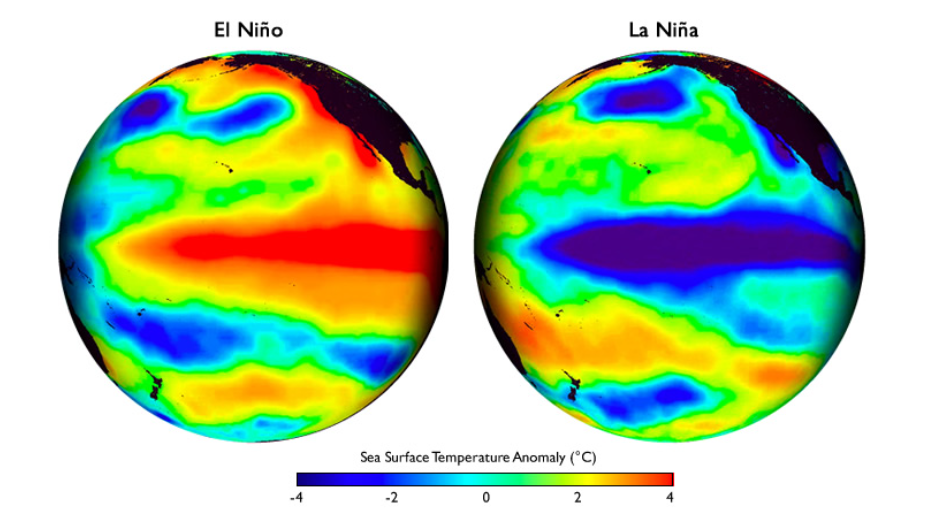
El Niño: the above-average sea-surface temperatures that periodically develop across the east-central equatorial Pacific.
Triggers
Shifted Jet Stream: During El Niño events, warmer Pacific Ocean temperatures disrupt atmospheric circulation patterns, weakening trade winds and shifts the jet stream (fast-moving air currents high in the atmosphere) northwards.
Suppressed Convection: The weakened trade winds and shifted jet stream lead to less upwelling of cold, nutrient-rich water off the South American coast.
This reduces evaporation and limits cloud formation (particularly over areas like Indonesia and Australia).
Reduced Rainfall: With less evaporation and cloud formation, regions experience significantly reduced precipitation, leading to drought conditions.
La Niña: the periodic cooling of ocean surface temperatures in the central and east-central equatorial Pacific.
Triggers
Intensified Trade Winds: La Niña is characterized by stronger trade winds pushing warm surface water westward towards Asia which enhances upwelling of cold water off the west coast of South America.
Altered Atmospheric Circulation: The stronger trade winds and cooler eastern Pacific waters also influence atmospheric circulation.
La Niña can shift the jet stream southward, bringing drier conditions to parts of southern North America and East Africa.
Disrupted Precipitation Patterns: These changes in atmospheric circulation disrupt usual precipitation patterns, leading to drought conditions in some regions.
Contrasting Tropical Storm
Type | Cause | Impact | Response | |
|---|---|---|---|---|
Typhoon Haiyan (Philippines, 2013) | Super Typhoon | The following fueled Typhoon Haiyan’s development.
|
|
|
Storm Abigail (UK, 2015) | Extratropical Storm (originally a subtropical storm) | Originated as a subtropical storm and transitioned into an extratropical storm before impacting the UK.
| Although not as powerful as Typhoon Haiyan, Storm Abigail;
|
|
Contrasting Droughts: UK vs. Madagascar
Cause | Impact | Response | |
|---|---|---|---|
UK Drought of 1976 | The most severe drought in the 20th century for the UK. Factors are;
|
|
|
Madagascar Drought 2018-Present | Madagascar has been experiencing a prolonged drought since 2018, with some areas not receiving significant rainfall for over a decade. The causes are complex and multifaceted.
|
|
|
1.2 How do plate tectonics shape our world?
The Structure of the Earth
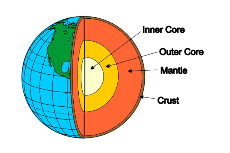
Earth’s Layers
Crust: The outermost, thin, solid layer (around 30-70 km thick). It's like the Earth's skin, consisting of two main types:
Continental Crust: Thicker and less dense, made up mostly of granite and other rocks. Continents sit on continental crust.
Oceanic Crust: Thinner and denser, composed mainly of basalt. Ocean floors are made of oceanic crust.
Mantle: The thickest layer, made up of hot, solid rock (about 2800 km thick). It's mostly solid but can deform slowly under immense pressure and heat.
Upper Mantle: More rigid due to cooler temperatures. The solid portion of the upper mantle, along with the crust, forms the lithosphere, which is broken into tectonic plates.
Outer Core: Liquid layer made of superhot molten iron and nickel (about 2200 km thick). It's the movement within this layer that's crucial to plate tectonics.
Inner Core: Solid sphere of iron and nickel at the Earth's center (about 1200 km radius).
Convection Currents and Plate Tectonics
Plate Tectonics: a theory explaining the structure of the earth's crust and many associated phenomena as resulting from the interaction of rigid lithospheric plates which move slowly over the underlying mantle.
Convection Currents: a process that involves the movement of energy from one place to another
The key to plate tectonics lies within the outer core.
The extreme heat from the Earth's interior and the decay of radioactive elements in the mantle cause the outer core to be molten.
This molten material constantly flows in a circular motion called convection currents.
These currents transfer heat from the Earth's interior towards the surface.
As the hot, molten rock in the outer core rises towards the mantle, it loses heat and cools. This cooler, denser material then sinks back down towards the core.
This continuous cycle of rising and sinking hot rock creates a churning motion within the mantle.
The Link to Plate Tectonics
The Earth's layered structure, with the movement of hot, molten material in the outer core driving convection currents in the mantle, provides the underlying mechanism for plate tectonics. These plate movements shape the Earth's surface and influence many geological processes.
The solid upper mantle, along with the crust, is rigid and doesn't flow as easily as the liquid outer core. However, it's "dragged along" by the convection currents in the mantle below.
These currents cause the plates to move horizontally across the Earth's surface at a very slow pace (a few centimeters per year).
The movement and interaction of these plates (converging, diverging, or sliding past each other) create various geological features and phenomena, including:
Earthquakes: Occur along plate boundaries where plates grind, collide, or pull apart.
Volcanoes: Form at plate boundaries where molten rock (magma) from the mantle erupts onto the surface.
Mountain ranges: Created when plates collide and push against each other, forcing rock layers to buckle and rise.
Processes that Take Place at Constructive, Destructive, Conservative, and Collision Plate Boundaries
Constructive Plate Boundaries (Divergent Boundaries): Plates that diverge or pull away from each other.
Process: As the plates move apart, hot molten rock (magma) from the mantle rises to fill the gap.
This magma cools and solidifies, forming new oceanic crust and expanding the seafloor.
Result: Mid-ocean ridges, underwater mountain ranges, are formed due to continuous upwelling of magma.
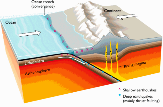
Destructive Plate Boundaries (Convergent Boundaries): One plate dives (subducts) beneath another.
Process: The denser oceanic crust sinks beneath the lighter continental crust, pushing it upwards and creating deep trenches.
As the subducted plate descends, the heat and pressure cause some of its rock to melt, forming magma. (This magma can rise and erupt, creating volcanoes)
Result: Depending on the type of crust involved, subduction can form:
Oceanic-Continental Convergence: Creates mountain ranges on the continent and volcanic arcs offshore. Examples are;
Mountain Ranges - Andes Mountains
Volcanic Arc Offshore - Cascade Mountains
Oceanic-Oceanic Convergence: Forms deep ocean trenches and volcanic island arcs.
Example: Mariana Trench and Marianas Islands
Conservative Plate Boundaries (Transform Boundaries): Plates that slide horizontally in opposite directions.
Process: These boundaries don't create or destroy crust, but the friction between plates can cause immense pressure, leading to earthquakes and landform shearing.
Result: The San Andreas Fault in California is a famous example.
These boundaries don't involve volcanic activity as no melting occurs.
Collision Zone Boundaries: A special case of convergent boundaries occurs when two continental plates collide head-on. Due to their similar densities, neither subducts easily.
Process: The immense force buckles and crumples the continental crust, pushing it upwards and forming massive mountain ranges.
Result: The Himalayas, formed by the collision of the Indian and Eurasian plates, are a prime example.
Hotspots: Stationary plumes of hot molten rock rising from deep within the mantle, typically not located at plate boundaries.
Process: As these plumes reach the surface, they melt the overlying crust, creating volcanic activity.
If the hotspot is beneath the ocean floor, it can create a chain of volcanic islands or seamounts as the plate carrying them moves over the hotspot.
Result: The Hawaiian Islands are a classic example, formed as the Pacific Plate moves over a hotspot.
Yellowstone National Park is another example of a hotspot-related volcanic region, though currently above ground.
Movement of Tectonic Plates Causing Earthquakes and Volcanoes
Tectonic plate movement is the driving force behind both earthquakes and volcanoes, but the specific types (shallow vs deep focus earthquakes, shield vs composite volcanoes) arise from the nature of the plate interaction and the resulting geological processes.
Earthquakes and Plate Boundaries
Earthquakes: Occurs when sudden movement or stress release happens along plate boundaries. The type of earthquake depends on the location of the movement within the Earth:
Shallow-Focus Earthquakes: The most common and destructive earthquakes.
They occur at relatively shallow depths within the Earth's crust, typically less than 70 kilometers (43 miles) from the surface.
Causes: The movement of tectonic plates creates stress and strain on the rocks along plate boundaries. Over time, this stress builds up until the rock can no longer withstand the pressure and fractures.
This sudden release of energy creates the seismic waves we feel as earthquakes.
Deep-Focus Earthquakes: These are less frequent but can be powerful.
They occur at depths exceeding 300 km, typically within subducting oceanic plates.
Causes: The immense pressure and heat at these depths cause the rock to deform in a ductile (bendable) way, leading to sudden breaks and deeper earthquakes.
Volcanoes and Plate Boundaries
 The location and type of volcano are linked to the type of plate boundary and the resulting magma composition.
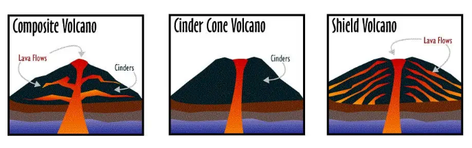
Shield Volcanoes: Broad, gently sloping volcanoes with a dome-like shape.
Erupts fluid, low-silica basaltic lava that flows easily, forming the characteristic shield shape. These are located at;
Constructive boundaries (divergent boundaries): As plates diverge, upwelling magma from the mantle, rich in basaltic components, erupts to form these volcanoes. Mid-ocean ridges have many shield volcanoes.
Hotspots: Erupts basaltic lava, forming shield volcanoes like those in Hawaii.
Cinder Cone Volcanoes: the most common type of volcano found on Earth.
Formed when gas-charged lava is erupted from a single vent.
Composite Volcanoes: (known as stratovolcanoes) are steep-sided, conical mountains with alternating layers of ash, lava, and rock debris. They erupt with a more explosive style due to:
Location: Composite volcanoes are commonly found at:
Convergent boundaries (subduction zones): Subducted oceanic crust melts due to heat and pressure, releasing water-rich magma.
This wetter magma traps gases, causing explosive eruptions that build up the characteristic layered structure. (ex. Mount Fuji)
Hazards of Tectonic Plates Movement
Case Study: The 2011 Tōhoku Earthquake and Tsunami, Japan
Happened on March 11, 2011, off the coast of northeastern Japan.
A megathrust earthquake, triggered by the subduction of the Pacific Plate beneath the Philippine Sea Plate.
Causes |
|
|---|---|
Impact/Consequences |
|
Responses |
|
Mitigating Earthquakes with Technology
Although earthquakes can not be completely prevented, technological advancements provides an opportunity to reduce its impact on human life and infrastructure. The followings are to be considered in mitigating earthquake hazards;
Building Design
Seismic-Resistant Construction: Advancements in engineering allow for buildings designed to withstand strong shaking.
Techniques like base isolation (isolating buildings from the ground) and using energy-absorbing materials can significantly reduce structural damage.
Building Codes and Regulations: Regularly updated building codes based on the latest earthquake science ensure new structures are built for resilience.
Existing buildings can be retrofitted with reinforcements to improve their earthquake resistance.
Smart Building Materials: Emerging materials like self-healing concrete that can repair cracks or shape-memory alloys that return to their original form after deformation offer promising possibilities for earthquake-resistant infrastructure.
Prediction and Early Warning Systems
Earthquake Monitoring Networks: Densely distributed seismic sensor networks can detect subtle changes in ground movement that might precede earthquakes.
Real-time data analysis of these networks can potentially provide crucial seconds of warning before strong shaking arrives.
AI-powered Prediction Models: Artificial intelligence can analyze vast amounts of seismic data to identify patterns and correlations that might lead to improved earthquake prediction capabilities.
While true earthquake prediction remains elusive, earlier warnings can still be lifesaving.
Early Warning Systems for Public Alerts: Advanced communication technologies can be used to disseminate real-time earthquake alerts to the public via smartphones, loudspeakers, and other channels.
These warnings allow people to take cover, drop, hold on, and evacuate if necessary.
II. Climate Change
2.1 What evidence is there to suggest climate change is a natural process?
Pattern of Climate Change
Glacial Periods (Ice Ages)
These periods lasted for much longer durations, typically tens of thousands of years.
Extensive ice sheets covered large parts of North America and Eurasia, lowering sea levels significantly.
Colder global temperatures prevailed, with drier conditions in many regions.
Interglacial Periods
These were relatively warm intervals lasting several thousand years.
The ice sheets retreated, leading to rising sea levels.
Global temperatures were warmer, with increased precipitation and vegetation growth in many areas.
The Current Interglacial
We are currently living in an interglacial period known as the Holocene epoch, which began about 11,700 years ago.
However, human activities, particularly the burning of fossil fuels, are causing unprecedented rates of global warming, disrupting the natural pattern of these cycles.
Causes of the Cycles
The primary drivers of these glacial and interglacial cycles are variations in Earth's orbit around the Sun and the tilt of its axis (Milankovitch cycles).
These changes in orbital parameters affect the amount of solar radiation reaching Earth at different latitudes, influencing global temperatures.
Additionally, natural fluctuations in greenhouse gas concentrations, such as carbon dioxide, may have played a role in amplifying these cycles.
Impact
Climate cycles impacts the evolution and distribution of life on Earth.
During glacial periods, many species adapted to the colder environment, while others migrated to more favorable regions.
Interglacial periods allowed for the expansion of plant and animal life.
The rapid pace of current warming associated with human activity poses a significant threat to ecosystems and biodiversity that have adapted to the relatively stable climate of the Holocene.
The Range and Reliability of Evidence Relating to Climate Change
The evidence for climate change comes from a variety of sources. The strength of this evidence lies in the convergence of multiple lines of evidence.
High Reliability Evidence
Global Temperature Data
Range: Instrumental records of temperature measurements have been collected since the 1880s, with increasing coverage and accuracy over time. Satellite data provides additional information for recent decades.
Reliability: This data is highly reliable because it is collected using consistent methodologies and undergoes rigorous quality control processes. The long-term trends are clear and corroborated by multiple independent datasets.
Ice Cores
Range: Ice cores drilled from glaciers and polar ice sheets trap air bubbles and layers of snow that can be analyzed for temperature, greenhouse gas concentrations, and other information. Cores can extend back hundreds of thousands of years.
Reliability: Ice core data is highly reliable because the trapped air and ice provide a direct record of past atmospheric conditions. Multiple ice cores from different locations show consistent patterns, strengthening the evidence.
Moderate Reliability Evidence
Sea Ice Positions
Range: Satellite data and historical observations track changes in sea ice extent and thickness.
Reliability: While satellite data is reliable, interpreting sea ice changes can be complex. Factors like wind patterns and natural variations can influence sea ice coverage in the short term. However, the long-term decline in Arctic sea ice aligns with other evidence of climate change.
Low Reliability Evidence
Paintings and Diaries
Range: Historical records like paintings and diaries can offer anecdotal evidence of past climate conditions.
Reliability: These sources are unreliable for pinpointing specific climate trends. They may be subjective, lack precise measurements, and be influenced by the artist's or writer's perspective and purpose.
Natural Causes of Climate Change
Theory | Evidence | Limitations | |
|---|---|---|---|
Sunspots and Solar Activity | Suggests that variations in sunspot activity might influence Earth's climate.
| There is a correlation between sunspot cycles (lasting about 11 years) and some short-term climate fluctuations. | The magnitude of these changes is relatively small compared to the current rate of warming.
|
Volcanic Eruptions | Can inject large amounts of ash, dust, and sulfur dioxide aerosols into the stratosphere.
| Volcanic eruptions like Mount Tambora's in 1815 led to a period known as "the year without a summer" due to global cooling. | The cooling effect of volcanic eruptions is temporary, lasting only a few years at most.
|
Milankovitch Cycles | Cycles describe variations in Earth's orbit around the Sun and the tilt of its axis.
| Geological records like ice cores and ocean sediments show strong correlations between Milankovitch cycles and past glacial and interglacial periods. | While Milankovitch cycles can explain the natural cycles of glaciation and interglaciation, they don't explain the rapid warming observed in the past century. |
The Greenhouse Effect
A natural process that warms the Earth's surface.
Acts like a giant blanket which traps some of the Sun's heat and preventing Earth from becoming a cold, desolate rock.
Human Impacts on the Atmosphere and the Enhanced Greenhouse Effect
Human activities significantly alter the natural balance of greenhouse gases in the atmosphere, leading to a phenomenon known as the enhanced greenhouse effect. It is done through;
Burning Fossil Fuels: Burning of fossil fuels like coal, oil, and natural gas are considered as the primary culprit.
Such activities release huge amount of carbon dioxide (CO2), contributing as the most abundant greenhouse gas into the atmosphere.
Deforestation: When trees are cut down (deforestation) for agriculture, development, or other purposes, we remove this natural carbon sink, allowing more CO2 to accumulate in the atmosphere.
Industrial Processes: Manufacturing processes in various industries also release greenhouse gases like CO2, methane, and nitrous oxide.
Agricultural Practices: Certain agricultural practices, such as intensive livestock farming and rice cultivation, contribute to methane emissions.
Consequences of the Enhanced Greenhouse Effect
The additional heat trapped by the increased concentration of greenhouse gases is causing the planet to warm at an alarming rate. The following are its consequences;
Rising Global Temperatures: The average global temperature has already increased by over 1°C since pre-industrial times, and it continues to rise.
Increased Extreme Weather Events: Warmer temperatures lead to more frequent and intense heatwaves, droughts, floods, storms, and wildfires.
Sea Level Rise: Melting glaciers and thermal expansion of ocean waters contribute to rising sea levels, threatening coastal communities and ecosystems.
Ocean Acidification: Increased CO2 dissolves in the oceans, making them more acidic, harming marine life.
Disruptions to Ecosystems: Climate change disrupts natural habitats and ecological processes, impacting biodiversity and food security.
Social, Economic and Environmental Impacts of Climate Change
Worldwide Impacts
Social Impacts
Food insecurity: Climate change disrupts agricultural patterns, leading to droughts, floods, and crop failures that threatens food security, particularly in vulnerable regions that rely on subsistence farming.
Water scarcity: Melting glaciers and changing precipitation patterns are leading to water scarcity in many areas that can lead to conflicts over water resources and hinder sanitation and hygiene practices, increasing the risk of waterborne diseases.
Health problems: Heatwaves, floods, and extreme weather events can cause heatstroke, dehydration, respiratory problems, and injuries.
Changing weather patterns also create ideal conditions for the spread of vector-borne diseases like malaria and dengue fever.
Economic Impacts
Infrastructure damage: Extreme weather events like hurricanes, floods, and wildfires cause widespread damage to infrastructure – roads, bridges, buildings, and power grids.
Rebuilding costs are enormous, placing a strain on national budgets.
Disruptions to industries: Climate change disrupts various industries, including agriculture, tourism, and fisheries.
Rising sea levels threaten coastal infrastructure and tourism destinations.
Changing weather patterns and increasing ocean acidity harm fish populations, impacting the fishing industry.
Loss of livelihoods: The consequences of climate change, like droughts and floods, can devastate local economies, particularly in developing countries.
Farmers and people dependent on natural resources lose their livelihoods, pushing them into poverty.
Insurance costs: The increasing frequency and intensity of extreme weather events lead to higher insurance premiums, further straining businesses and households.
Environmental Impacts
Sea level rise: Melting glaciers and thermal expansion of oceans are causing sea levels to rise, threatening coastal communities, ecosystems, and cultural heritage sites.
Low-lying island nations face the existential threat of being submerged.
Ocean acidification: Increased atmospheric CO2 dissolves in the oceans, making them more acidic which harms marine calcifying organisms like corals and shellfish, disrupting entire marine ecosystems.
Biodiversity loss: Climate change disrupts habitats and ecosystems, pushing plant and animal species towards extinction.
This loss of biodiversity can have cascading effects throughout the food chain.
Extreme weather events: Climate change leads to more frequent and intense heatwaves, droughts, floods, storms, and wildfires.
These events cause widespread damage to ecosystems, loss of wildlife habitat, and disruptions to natural processes.
Examples from the 21st Century
2011 Tohoku Earthquake and Tsunami (Japan): This devastating event, caused by rising sea levels linked to climate change, resulted in thousands of casualties, widespread infrastructure damage, and a nuclear crisis.
2015 Nepal Earthquake: The devastating earthquake highlighted the vulnerability of developing countries to climate-related disasters. Weak infrastructure made communities more susceptible to damage.
2010-2011 East African Droughts: Severe droughts in East Africa, linked to climate change, led to widespread hunger and malnutrition, displacing millions of people. This highlighted the increasing risk of food insecurity in vulnerable regions.
2022 Pakistan Floods: Devastating floods in Pakistan, caused by unprecedented monsoon rains linked to climate change, resulted in widespread damage, loss of life, and displacement.
Impacts in the United Kingdom
Social Impacts
Heatwaves and health risks: More frequent and intense heatwaves pose a health risk, particularly for vulnerable populations like the elderly and young children. Heatstroke, dehydration, and respiratory problems become more common.
Flooding and disrupted communities: Heavy downpours and unpredictable rainfall patterns lead to increased flooding events. This damages homes, infrastructure, and disrupts communities, causing displacement and economic hardship.
Mental health concerns: The changing climate and extreme weather events can be a source of anxiety and stress for many people, impacting mental well-being.
Shifts in leisure activities: Warmer weather may extend the summer season, but it can also disrupt traditional outdoor activities due to extreme heat or unpredictable downpours.
Economic Impacts
Damage to infrastructure: Flooding and storms damage roads, bridges, and other infrastructure, costing billions of pounds to repair and rebuild.
Disruptions to agriculture: Changing weather patterns and increased droughts can harm crop yields, impacting the agricultural sector and potentially leading to food price increases.
Costs of adaptation: The UK needs to invest in adaptation strategies like flood defenses, heat-resistant infrastructure, and early warning systems. These investments come with significant costs.
Impact on tourism: While warmer weather might attract some tourists, extreme weather events can disrupt tourism seasons and damage coastal areas.
Environmental Impacts
Loss of biodiversity: Warming temperatures and changes in precipitation patterns threaten habitats and ecosystems. Species reliant on specific conditions may struggle to adapt, leading to biodiversity loss.
Coastal erosion: Rising sea levels and stronger storms cause coastal erosion, threatening coastal communities and ecosystems.
Changes in wildlife behavior: Animals are adapting to the changing climate, with some species shifting their ranges or breeding patterns. This disrupts established ecological relationships.
Increased wildfires: Drier conditions and heatwaves can increase the risk of wildfires, damaging ecosystems and impacting air quality.
Examples from the 21st Century
2003 European Heatwave: This record-breaking heatwave caused thousands of deaths in the UK, highlighting the vulnerability of populations to extreme heat events.
2015-2016 Winter Floods: Devastating floods in parts of England and Wales caused billions of pounds in damage and displacement, exposing the need for stronger flood defenses.
2018 Summer Heatwave: The hottest summer on record in the UK resulted in wildfires, drought conditions, and infrastructure disruptions.
2022 Storm Eunice: This severe storm caused widespread damage to property and infrastructure, raising concerns about the increasing intensity of storms linked to climate change.
III. Distinctive Landscapes
3.1 What makes a landscape distinctive?
Landscape: All the visible features of an area of countryside or land, often considered in terms of their aesthetic appeal. It is a complex and multifaceted concept that encompasses;
Physical Elements: Landforms (mountains, hills, rivers, valleys), geological features, water bodies, and the living elements like vegetation (forests, grasslands).
Human Elements: Buildings, infrastructure (roads, bridges), agricultural fields, and other structures built by humans.
Sensory Qualities: The visual impression, sounds, smells, and even the feeling of being in a particular place contribute to the landscape experience.
Cultural and Historical Associations: The stories, traditions, and meanings people attach to a place become part of the landscape.
Natural and Built Landscape
Natural Landscapes: These landscapes are primarily shaped by natural processes over long timescales.
Includes forests, deserts, mountains, wetlands, rivers, and oceans.
May have minimal human influence, or the human elements are relatively small-scale and integrated into the natural environment.
Built Landscapes: These landscapes are dominated by human-made features.
Includes cities, towns, suburbs, agricultural fields, and transportation networks.
While some natural elements may be present (parks, gardens), they are often modified and managed by humans.
Distribution of Upland, Lowland and Glaciated Landscape in the Uk
The distribution of the following landscapes are not always certain. Uplands can transition into lowlands with rolling foothills and human activity has also shaped landscapes.
Uplands
Typically characterized by higher elevations, steeper slopes, and harsher weather conditions compared to lowlands.
Known for their scenic beauty and are popular for outdoor activities like hiking and climbing.
Location: Generally found in the north and west of the UK, forming the high ground regions.
Key Areas:
Scotland: The Scottish Highlands, including iconic peaks like Ben Nevis, dominate the northern landscape.
England: The Pennines, a north-south mountain range stretching from the Scottish border to the Peak District, and the Lake District in northwest England are prominent upland areas.
Wales: Snowdonia in North Wales is a mountainous region with the highest peak in Wales (Snowdon).
Lowlands
Generally have lower elevations, rolling hills, and gentler slopes.
Often characterized by fertile soils, making them ideal for agriculture and supporting a higher population density.
Often home to major cities, towns, and transportation networks.
Location: Occupy most of southern and eastern England, extending into parts of Wales and Scotland.
Key Areas:
England: The vast majority of England is considered lowland, including the fertile plains of eastern England and the Midlands.
Wales: The South Wales Valleys and coastal plains are lowland areas.
Scotland: The Central Belt of Scotland, running from Glasgow to Edinburgh, is a lowland region.
Glaciated Landscapes
Recognizable by features like U-shaped valleys carved by glaciers, corries (circular hollows), and pyramidal peaks.
Some areas have exposed bedrock due to glacial scouring, while others have glacial till (deposited rock debris) creating hillier terrain.
Location: While glaciation sculpted much of the UK landscape during the ice ages, the most prominent evidence remains in:
Scotland: The Scottish Highlands display classic glacial features like U-shaped valleys (e.g., Glen Coe), corries (cirque lakes), and rugged mountain peaks.
Lake District (England): This region has numerous lakes and valleys formed by glacial activity.
Wales: Snowdonia has some glacial landforms, but they are less extensive compared to Scotland.
3.2 What influences the landscapes of the UK?
Geomorphic Processes that are Involved in Shaping Landscapes
Weathering: The breakdown and alteration of rocks and minerals at the Earth's surface, preparing them for erosion.
Mechanical Weathering: Physical processes break down rocks into smaller fragments without altering their chemical composition. Examples are:
Freeze-thaw: Water seeping into cracks in rocks expands when it freezes, wedging the rock apart.
Heating and Cooling: Expansion and contraction of rocks due to temperature changes can cause them to crack.
Exfoliation: Outer layers of rock peel away due to temperature fluctuations.
Chemical Weathering: Chemical reactions transform rocks and minerals, changing their composition. Examples are:
Dissolution: Water dissolves some minerals in rocks, like limestone.
Oxidation: Rocks containing iron react with oxygen in the air, forming rust (iron oxide).
Hydrolysis: Water reacts with minerals, altering their chemical structure.
Biological Weathering: Plants, animals, and microorganisms contribute to rock breakdown. Examples are:
Plant roots: Roots grow in cracks, wedging rocks apart.
Animal burrowing: Animals like burrowing rodents break up rocks and soil.
Lichens and moss: These organisms release acids that slowly dissolve rock minerals.
Mass Movement: Downslope movement of rock, soil, and other debris under the influence of gravity. Examples are:
Slides: Rapid movement of large masses of rock or debris down a slope.
Slumps: Downward and rotational movement of a block of rock or soil along a curved surface.
Earthflows: Slow, continuous movement of saturated soil down a slope.
Erosion: The removal and transportation of loosened rock and soil particles by various agents. Examples are:
Abrasion: Rocks and particles grind against each other, causing wear and tear. (Think sandpaper smoothing a rock)
Hydraulic Action: Moving water (waves, rivers) exerts force, breaking off rock fragments. (like waves crashing against cliffs)
Attrition: Particles collide and break into smaller pieces as they are transported. (Rocks tumbling in a river become smoother)
Solution: Water dissolves some minerals, carrying them away in solution. (Limestone caves are formed by this process)
Transport: The movement of eroded particles by wind, water, glaciers, or gravity. Mechanisms are:
Traction: Particles are dragged or rolled along the ground by wind or water. (Imagine pebbles being pushed along a riverbed)
Saltation: Particles bounce and skip along the surface, propelled by wind or water. (Think sand blowing across a beach)
Suspension: Fine particles are carried within a fluid (air or water) for extended periods. (Dust storms and muddy rivers transport sediment in suspension)
Deposition: The accumulation of transported sediment in new locations which occurs when the agent carrying the particles loses energy and can no longer transport them. Examples are:
Sedimentary rocks: Layers of deposited sediments get compacted and cemented over time, forming sedimentary rocks like sandstone and shale.
Alluvial plains: Floodplains formed by the deposition of sediments by rivers.
Windblown deposits: Sand dunes are formed by the accumulation of wind-blown sand.
Glacial deposits: Till (unsorted glacial debris) and moraines (deposits left by glaciers) are formed by the deposition of material transported by glaciers.
Formation of Coastal Landforms
Coastal landforms are dynamic and constantly evolving. The following are how various coastal landforms are formed through erosion and deposition;
Erosion by Waves
Waves carry tremendous energy, and as they interact with the coastline, they erode the land, creating various features.
The erosive power of waves depends on factors like wave height, wave frequency, and the type of rock the waves are hitting.
Landforms Created by Erosion
Erosion: the geological process in which earthen materials are worn away and transported by natural forces such as wind or water.
Headlands: Are areas of high land that jut out into the sea.
Typically formed from more resistant rock types that can withstand erosion better than the surrounding areas. As waves erode softer rocks, headlands are left behind.
Bays: Are curved indentations in the coastline between headlands.
Forms where waves have eroded softer rocks or where weaknesses in the rock allow for faster erosion.
Landforms Created by Differential Erosion
Differential Erosion: A geological process in which different rock layers or materials are eroded at varying rates due to differences in their resistance to weathering and erosion.
Caves: Waves constantly batter the coast, and over time, cracks and weaknesses in the rock are exploited.
Hydraulic action (the force of water) and abrasion gradually carve out hollows in the rock face, forming caves.
Arches: As caves grow deeper, the roof thins and weakens. Eventually, the roof collapses, leaving behind a natural arch.
Continued erosion can further widen the arch until it eventually becomes a;
Stack: A tall, isolated pillar of rock standing offshore. I
It was once connected to the mainland as part of a headland or arch, but further erosion isolated it.
Deposition by Waves
Waves don't just erode; they also transport and deposit eroded materials along the coast. This process creates new landforms:
Beach: An accumulation of loose sediment (sand, pebbles, or cobbles) deposited by waves along the coast.
The size and composition of the beach material depend on the source of the eroded material and the wave energy.
Spit: Are elongated narrow strips of land that project out from the coast at an angle.
Forms when longshore drift (the movement of sediment parallel to the shore by waves) deposits material in one direction.
Formation of River Landforms
Landforms Created by Erosion
Waterfall: Occurs where the river encounters a sudden drop in elevation, often due to differences in rock hardness.
The constant pounding of water at the base of the waterfall erodes the rock further, causing the waterfall to retreat upstream over time.
Gorge: As a waterfall retreats upstream due to erosion, it leaves behind a steep-sided canyon (gorge).
Typically deep and narrow, with exposed rock faces showcasing the power of erosion.
V-shaped Valleys: Deep, narrow valleys with steep sides that form in the upper course of a river.
High velocity and strong vertical erosion dominate here, as the river cuts downwards.
Erosion and Deposition
As rivers flow through flatter areas, their velocity decreases, leading to a shift between erosion and deposition.
Floodplain: A flat, low-lying area bordering the river channel.
During floods, the river overflows its banks and deposits sediment on the floodplain.
Landforms Created by Erosion and Deposition
Meander: As a river flows across a floodplain, it may develop bends or curves called meanders.
The faster-flowing water on the outside of the bend erodes the bank, while sediment is deposited on the inside of the bend where the flow is slower (creating a snake-like pattern).
Levee: Are natural embankments that form along the edges of the river channel.
Formed by the deposition of the coarsest sediments carried by the river during floods.
Can help contain the river during periods of high flow.
Ox-bow Lake: Over time, meanders can become more pronounced. If a meander neck (the narrow part of the bend) is breached by floodwater, the river cuts a new, straighter channel, isolating the old bend.
The isolated loop of water becomes an ox-bow lake.
Case Study of 2 UK Landscapes
Coastal Landscape
Landforms | Geomorphic Processes | Human Activity and Management | |
|---|---|---|---|
The Jurassic Coast (Dorset, England) |
|
|
|
River Basin
Landforms | Geomorphic Processes | Human Activity and Management | |
|---|---|---|---|
The Lake District National Park (Cumbria, England) |
|
|
|
IV. Sustaining Ecosystems
4.1 Why are natural ecosystems important?
Concept of Ecosystem
Ecosystem: A community of living organisms in conjunction with the nonliving components of their environment, interacting as a system.
These components include climate, soil, water, plants, and animals.
The interdependence among these elements ensures the functioning and sustainability of the ecosystem.
Global Distribution of Ecosystems and the Climate, Flora, and Fauna
Polar Regions
Located in the northernmost and southernmost parts of the Earth.
Examples: The Arctic and Antarctic regions.
Climate - Extremely cold with ice and snow cover
Flora - Limited vegetation, mainly mosses, lichens, and low-growing shrubs
Fauna - Polar bears, penguins, seals, and various bird species
Coral Reefs
Found in warm, shallow ocean waters, primarily in the tropics.
Notable regions include the Great Barrier Reef in Australia and coral reefs in the Caribbean Sea.
Climate - Warm, tropical ocean waters
Flora - Algae and seagrasses
Fauna - Corals, fish, molluscs, and a wide variety of marine life
Grasslands
Spread across various continents, including the prairies of North America, the pampas of South America, the steppes of Eurasia, and the savannas of Africa.
Climate - Varies from temperate to tropical, with moderate to low rainfall
Flora - Grasses and small shrubs
Fauna - Grazing animals like bison and antelope, predators like lions and cheetahs, and various birds and insects
Temperate Forests
Found in regions with moderate climates, including parts of North America, Europe, and Asia.
Examples: Deciduous forests and mixed forests.
Climate - Moderate temperatures with distinct seasons
Flora - Deciduous trees and coniferous trees
Fauna - Deer, bears, squirrels, and numerous bird species
Tropical Forests
Located near the equator, in regions with high rainfall and temperatures.
Examples: Amazon Rainforest in South America and the Congo Basin in Africa.
Climate - Warm and humid with high rainfall
Flora - Dense vegetation, including tall trees, vines, and a wide variety of plant species
Fauna - Monkeys, jaguars, parrots, insects, and countless other species
Hot Deserts
Located in regions with extremely low precipitation and high temperatures.
Examples: Sahara Desert in Africa and the Arabian Desert in the Middle East.
Climate - Extremely dry with very high temperatures
Flora - Cacti, succulents, and drought-resistant shrubs
Fauna - Camels, reptiles, insects, and nocturnal animals adapted to arid conditions.
Terms
Climate: The weather conditions prevailing in an area in general or over a long period.
Flora: All the plant life present in a particular region or time, generally the naturally occurring (indigenous) native plants.
Fauna: The animals of a particular region, habitat, or geological period.
4.2 Why should tropical rainforests matter to us?
Distinctive Characteristics of a Tropical Rainforest Ecosystem and Its Interdependence
Tropical rainforests are Earth's powerhouses of biodiversity. It is characterized by the following;
Climate |
|
|---|---|
Nutrient Cycle |
|
Soil Profile |
|
Water Cycle |
|
Interdependence in Tropical Rainforests
Tropical rainforests are a vibrant tapestry of life, where each element (climate, soil, water, plants, animals, and human activity) is intricately connected and influences the others.
Climate |
|
|---|---|
Soil |
|
Water |
|
Plants |
|
Animals |
|
Human Activity |
|
Value of Tropical Rainforests Through the Study of their Goods and Services
Goods
Timber: Though selective logging is crucial for sustainability, rainforests offer a source of hardwood timber for construction and furniture. However, responsible forestry practices are essential to avoid deforestation.
Non-timber forest products: Include fruits, nuts, oils, resins, and medicinal plants that provide local communities with food, income, and traditional medicines.
Sustainable harvesting of these resources is vital.
Biodiversity: Rainforests offer a treasure trove of genetic diversity, with potential for new medicines, food sources, and industrial materials.
Bioprospecting (the process of searching for these resources), should be done ethically with benefit-sharing agreements with local communities.
Services
Climate Regulation: Rainforests absorb vast amounts of carbon dioxide, a greenhouse gas, mitigating climate change.
Also releases water vapor through evapotranspiration, influencing regional rainfall patterns.
Water Regulation: The dense vegetation slows down rainwater, allowing for better infiltration and reducing floods.
Rainforests act like giant sponges, storing and releasing water slowly, regulating regional water supplies.
Soil Conservation: Tree roots hold soil in place, preventing erosion.
The rapid decomposition cycle in rainforests also helps maintain soil fertility.
Biodiversity Support: Rainforests provide habitat for millions of species, playing a vital role in maintaining global biodiversity.
This is crucial for healthy ecosystems and the services they provide.
Cultural Significance: Rainforests have deep cultural and spiritual significance for indigenous communities who have lived in harmony with these ecosystems for millennia.
Preserving rainforests also protects these cultural values.\
Human Impacts in the Tropical Rainforest
Logging
Habitat Destruction: Large-scale logging removes trees, destroying animal habitats and disrupting food webs. This can lead to population declines and even extinction of some species.
Soil Erosion: Loss of tree cover exposes the soil to heavy rainfall, leading to erosion. This washes away valuable nutrients and reduces soil fertility.
Disruption of Water Cycle: Trees play a crucial role in evapotranspiration. Reduced tree cover can alter rainfall patterns and disrupt the water cycle in the region.
Biodiversity Loss: Selective logging can disrupt the delicate balance of the ecosystem, even if some trees are left standing. Loss of a particular tree species can have cascading effects on other organisms that depend on it for food or shelter.
Mineral Extraction
Habitat Fragmentation: Mining activities fragment the rainforest, creating isolated patches of forest that are less viable for many species.
Pollution: Mining often involves the use of chemicals and heavy machinery, leading to water and soil pollution which can contaminate water sources and harm aquatic and terrestrial life.
Deforestation: Establishing mines and access roads often requires clearing large areas of forest, further contributing to habitat loss.
Social Impacts: Indigenous communities living in rainforests can be displaced by mining operations, disrupting their traditional way of life and cultural practices.
Agriculture
Deforestation: Conversion of rainforest land for large-scale agriculture is a major driver of deforestation which destroys vast areas of habitat and reduces biodiversity.
Soil Degradation: Monoculture farming practices (planting only one crop) can deplete soil nutrients, leading to soil degradation and reduced productivity over time.
Use of Pesticides and Herbicides: These chemicals can harm rainforest ecosystems by killing beneficial insects and pollinators, disrupting the food web.
Greenhouse Gas Emissions: Clearing forests releases stored carbon dioxide, contributing to climate change.
Unsustainable agricultural practices like slash-and-burn farming can also increase greenhouse gas emissions.
Tourism
Habitat Disturbance: Ecotourism, while intended to be sustainable, can still have negative impacts if not managed responsibly.
Increased foot traffic can damage vegetation and disturb wildlife.
Infrastructure Development: Building resorts, roads, and other infrastructure to accommodate tourists can lead to deforestation and habitat fragmentation.
Introduction of Invasive Species: Tourists can unintentionally introduce invasive plants or animals that can disrupt the rainforest ecosystem.
Waste Generation: Improper waste management from tourist activities can pollute the environment and harm wildlife.
Case Study: The Maya Biosphere Reserve
The Maya Biosphere Reserve (MBR) in Guatemala
An example of a large-scale initiative striving for sustainable management of a tropical rainforest ecosystem.
Established in 1990
Encompasses over 2.1 million hectares, protecting a vast area of Mayan cultural heritage and diverse rainforest ecosystems.
Key Sustainable Management Strategies:
Ecotourism
Community-based ecotourism: Local communities manage lodges and guided tours, fostering a sense of ownership and ensuring benefits from tourism directly reach them.
Incentivizes conservation efforts.
Low-impact practices: Tourist activities are designed to minimize ecological impact.
Hiking trails are well-defined, visitor numbers are limited, and education about responsible tourism is emphasized.
Community Programs
Sustainable agriculture: Programs promote techniques like agroforestry (integrating trees into farms) and shade-grown coffee, reducing deforestation and creating alternative income sources for local communities.
Capacity building: Training programs equip locals with skills in sustainable resource management, ecotourism management, and handicraft production, promoting economic self-sufficiency.
Cultural preservation: Programs support traditional Mayan cultural practices and handicrafts, fostering a sense of pride and connection to the rainforest.
Biosphere Reserve
Zoning: The MBR is divided into zones with varying levels of protection and permitted activities allowing controlled resource use in some areas while strictly protecting core wilderness areas.
Research and Monitoring: Ongoing research on flora, fauna, and ecological processes informs management decisions and helps track the effectiveness of conservation efforts.
Collaboration: The MBR is managed through a multi-stakeholder body involving government agencies, NGOs, local communities, and research institutions, ensuring a collaborative approach to conservation.
Sustainable Forestry
Selective logging: Limited logging is permitted in designated areas, with strict regulations to ensure minimal environmental impact and promote forest regeneration.
Reduced-impact logging (RIL) practices: These practices minimize damage to the remaining forest during logging operations.
Reforestation programs: Planting native trees in degraded areas helps restore the forest and provide future timber resources.
4.3 Is there more to polar environments than ice?
Distinctive Characteristics of Antarctica and the Arctic
Antarctica | |
|---|---|
Climate |
|
Land Features |
|
Sea Features |
|
Flora and Fauna |
|
Human Activity |
|
Arctic | |
|---|---|
Climate |
|
Land Features |
|
Sea Features |
|
Flora and Fauna |
|
Human Activity |
|
The Interdependence In Either The Antarctic or The Arctic Polar Region
Climate | Influences the distribution of ice and snow, which in turn affects soil formation and water availability. |
|---|---|
Soil and Water | Permafrost and ice cover impact soil development and the water cycle, affecting plant growth and animal habitats. |
Plants and Animals | Adaptations to extreme conditions create unique ecosystems with interdependent species. |
Human Activity | Scientific research, indigenous lifestyles, tourism, and resource extraction all interact with and impact these delicate ecosystems. |
Impacts of Human Activity On Either The Antarctic or The Arctic Ecosystems
Scientific Research |
|
|---|---|
Indigenous People (Arctic) | Indigenous communities rely on traditional practices, which are threatened by climate change and industrial activities. |
Tourism | Increasing tourism in the Arctic and Antarctica poses risks of pollution and disturbance to wildlife. |
Fishing and Whaling | Overfishing and whaling disrupt marine ecosystems and species populations. |
Mineral Exploitation | Mining activities pose significant environmental risks, including habitat destruction and pollution |
Case Study: One Small-Scale Example of Sustainable Management
Sustainable Tourism in Antarctica
Description: Strict regulations are in place to minimize environmental impact.
The International Association of Antarctica Tour Operators (IAATO) sets guidelines for visitor numbers, landing sites, and behavior to protect the fragile ecosystem.
Outcome: Helps reduce human footprint and educates visitors on conservation.
Case Study: One Global Example of Sustainable Management
The Antarctic Treaty System
Description: An international agreement signed in 1959, dedicated to preserving Antarctica for peaceful and scientific purposes.
Prohibits military activity, mineral mining, and ensures environmental protection.
Outcome: Successfully protects the continent's ecosystem and promotes international cooperation in scientific research.