knowt logo

Rocky Mountains 1 & 2

Rocky Mountains 1

Central United States

  • What defines the prairie complex in the central U.S.?

    • treeless; less than 10% forested

    • Why?

      • Too dry; less than 15 inches of rain

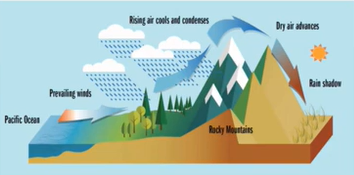
      • Rain shadow effect (rain drops in coastal areas because clouds don’t make it over mountains)

Rain shadow effect

  • Rain shadow: area of low rainfall on the leeward side of a mountain range, away from the prevailing weather system

    • as the clouds rise to move over the Rockies, their precipitation drops out as the air cools and condenses

    • Prairie: 15-20 inches of annual rainfall

    • Desert: less than 10 inches of rain

Rocky Mountains: Fast facts

  • The Rocky Mountain Complex stretches from Alberta to Mexico

  • States include MT, ID, ND, SD, KS, CO, UT, NM, NB, and part of TX, AZ, and WY

  • Mountains are taller younger drier and more rugged than the Appalachians

  • Formed 80-55 million years ago

  • In Mexico, they become the Sierra Madre

Sierra Madre Mountains

  • The Rocky Mountains split and become the Sierra Madre Mountains to the south, in Mexico

  • Sierra: rocky, ragged mountain range

  • Madre: mother

    • oriental: eastern, occidental: western

Rocky Mountains: Environmental gradients

  • about 30% forest cover; forest is patchy

  • Highest peak is Mt. Elbert, CO

  • But the “base” is also high—about 5000 ft

  • Lower average precipitation than the East

    • Denver: 12” annually

    • Salt Lake City: 14” annually

What are the key environmental factors that affect forests in the Rocky Mountains?

  • Elevation

  • Rainfall

  • Aspect

  • Topography

  • Fire history

Lower elevations: water

Higher elevations: other factors

Rocky Mountain Region Principles forest types (lowest to highest elevation)

Forest Zone

Description

Elevation

Annual rainfall

Transition

Non-forest to Forest

4000-5500 ft

<15”

Woodland

Widely spaced trees

5500-6000 ft

15-18”

Sub-montane

Ponderosa pine

6000-7000 ft

>18”

Montane

Varies, coniferous

7000-9000 ft

>18”

Sub-alpine

Spruce-fir forest

9000-11,000 ft

>18”

Rocky Mountain Forest Region Transition Zone

  • Transition zone is between areas that are too dry and just wet enough for shrubs and small trees

  • 4000-5500 ft elevation

  • Less than 15” of rainfall

  • Shrubby hardwoods (spacing and density)

  • overgrazing

  • sometimes called “sage-brush”

  • Principle species

    • cambel oak

    • mountain mahogany

    • sagebrush

Rocky Mountain Forest Region Woodland Zone

  • Found between 5500-6000 ft in elevation

  • Short, widely spaced trees > competition for water

  • Annual rainfall: 15-18 inches

  • Commonly called Pinyon pine—Juniper Woodland

  • Pinyon pine: pine nuts are an important and traditional food of the Navajo

  • Principal species:

    • Pinyon pine

    • Rocky Mountain juniper

Rocky Mountain Forest Region Submontane Zone

  • Found between 6000-7000 ft in elevation

  • Annual rainfall: >18 inches

  • Originally a fire-maintained savanna with widely spaced trees; today’s forests are denser

  • Denfse stands prone to insects, disease, and wildlife

  • Commonly called Ponderosa Pine Forest

  • Principle species:

    • ponderosa pine

      • vanilla-scented, very thick bark that sloughs off during fire

      • open crowns dissipate heat

      • one of the most fire-resilient pines owing to the thick bark

      • fire resistance increases with age

      • 3 needles per fascicle; large cones

Rocky Mountain Forests

  • Threats

    • Climate change causing changes in precipitation patterns

    • Recent history of fire suppression has caused fuel build-up and dense stands

    • Susceptible to beetle outbreaks and uncontrollable wildfires

Rocky Mountains 2

Rocky Mountain Geography

  • Rocky Mountains

  • Cascades

  • Sierra Nevada

  • Columbia Basin

  • Great Basin

  • Inland Empire

What are the key env. factors that affect forests in the Rockies?

  • Rainfall

  • elevation

  • aspect

  • topography

  • fire history

  • lower elvations—weather

  • higher elevations—other factors

Rocky Mountain Forest Region—Montane Zone

  • the Montane Zone varies more with latitude/geopgrahy than lower elevation forests

  • Also the most biologically diverse

  • WHY?

  • Found between 7000-9000 ft in elevation

  • Annual rainfall: >18 inches

  • Species composition more variable depending on geography. We’ll see several examples.

  • Forest structure ranges from open to closed canopy

  • Some of these forests are fire adapted

  • Principal species:

    • Douglas-fir

    • 2 varieties recognized: var. glauca and Pacific NW

    • Forms closed stands in some places, also grows in mixed stands

  • Drier sites (south and west):

    • Douglas-fir

    • Quaking aspen

    • Ponderosa pine

  • Moister sites (north)

    • Douglas fir

    • Western hemlock

    • Western redcedar

    • Grand fir

  • Fire-driven sites

    • Lodgepole pine

      • rockies: serotinous cones

    • Western white pine

    • Western larch

    • Quaking aspen

    • Fire interval 100-300 years

    • Stand-replacing catastrophic fire

  • Summary

    • Douglas-fir is the most widespread species; lots of variation by geography

    • Drier sites (south and west) get quaking aspen

    • Moister sites (north) and geography get western hemlock and western redcedar

    • Fire-adapted sites have lodgepole pine, which is adapted to periodic, stand-replacing fire

Rocky Mountain Forest Region Sub-Alpine Zone

  • Spruce-fir forest: 9000-11000 ft > 18” rainfall

    • highest forest zone below treeline

    • rainfall much less than the East

    • thin, rocky soils

    • high winds, cool, short summers, cold winters

    • disturbance includes avalanches

  • Evergreen canopy

  • Little to no understory—too rocky

  • Stunted near treeline

  • Principle species:

    • Englemann spruce, subalpine fir

Rocky Mountain Region Alpine Zone

  • >11,500 feet—climatic treeline

    • very harsh climate

    • extremely thin, rocky soils

    • high winds, cool, short summers, cold winters, deep snowpack

    • Alpine plants in miniature

    • Not quite tundra (no permafrost)

    • Protected areas can host a few adaptable pine species

    • Sprawling form

    • Bristlecone pine, limber pine, whitebark pine

R

Rocky Mountains 1 & 2

Rocky Mountains 1

Central United States

  • What defines the prairie complex in the central U.S.?

    • treeless; less than 10% forested

    • Why?

      • Too dry; less than 15 inches of rain

      • Rain shadow effect (rain drops in coastal areas because clouds don’t make it over mountains)

Rain shadow effect

  • Rain shadow: area of low rainfall on the leeward side of a mountain range, away from the prevailing weather system

    • as the clouds rise to move over the Rockies, their precipitation drops out as the air cools and condenses

    • Prairie: 15-20 inches of annual rainfall

    • Desert: less than 10 inches of rain

Rocky Mountains: Fast facts

  • The Rocky Mountain Complex stretches from Alberta to Mexico

  • States include MT, ID, ND, SD, KS, CO, UT, NM, NB, and part of TX, AZ, and WY

  • Mountains are taller younger drier and more rugged than the Appalachians

  • Formed 80-55 million years ago

  • In Mexico, they become the Sierra Madre

Sierra Madre Mountains

  • The Rocky Mountains split and become the Sierra Madre Mountains to the south, in Mexico

  • Sierra: rocky, ragged mountain range

  • Madre: mother

    • oriental: eastern, occidental: western

Rocky Mountains: Environmental gradients

  • about 30% forest cover; forest is patchy

  • Highest peak is Mt. Elbert, CO

  • But the “base” is also high—about 5000 ft

  • Lower average precipitation than the East

    • Denver: 12” annually

    • Salt Lake City: 14” annually

What are the key environmental factors that affect forests in the Rocky Mountains?

  • Elevation

  • Rainfall

  • Aspect

  • Topography

  • Fire history

Lower elevations: water

Higher elevations: other factors

Rocky Mountain Region Principles forest types (lowest to highest elevation)

Forest Zone

Description

Elevation

Annual rainfall

Transition

Non-forest to Forest

4000-5500 ft

<15”

Woodland

Widely spaced trees

5500-6000 ft

15-18”

Sub-montane

Ponderosa pine

6000-7000 ft

>18”

Montane

Varies, coniferous

7000-9000 ft

>18”

Sub-alpine

Spruce-fir forest

9000-11,000 ft

>18”

Rocky Mountain Forest Region Transition Zone

  • Transition zone is between areas that are too dry and just wet enough for shrubs and small trees

  • 4000-5500 ft elevation

  • Less than 15” of rainfall

  • Shrubby hardwoods (spacing and density)

  • overgrazing

  • sometimes called “sage-brush”

  • Principle species

    • cambel oak

    • mountain mahogany

    • sagebrush

Rocky Mountain Forest Region Woodland Zone

  • Found between 5500-6000 ft in elevation

  • Short, widely spaced trees > competition for water

  • Annual rainfall: 15-18 inches

  • Commonly called Pinyon pine—Juniper Woodland

  • Pinyon pine: pine nuts are an important and traditional food of the Navajo

  • Principal species:

    • Pinyon pine

    • Rocky Mountain juniper

Rocky Mountain Forest Region Submontane Zone

  • Found between 6000-7000 ft in elevation

  • Annual rainfall: >18 inches

  • Originally a fire-maintained savanna with widely spaced trees; today’s forests are denser

  • Denfse stands prone to insects, disease, and wildlife

  • Commonly called Ponderosa Pine Forest

  • Principle species:

    • ponderosa pine

      • vanilla-scented, very thick bark that sloughs off during fire

      • open crowns dissipate heat

      • one of the most fire-resilient pines owing to the thick bark

      • fire resistance increases with age

      • 3 needles per fascicle; large cones

Rocky Mountain Forests

  • Threats

    • Climate change causing changes in precipitation patterns

    • Recent history of fire suppression has caused fuel build-up and dense stands

    • Susceptible to beetle outbreaks and uncontrollable wildfires

Rocky Mountains 2

Rocky Mountain Geography

  • Rocky Mountains

  • Cascades

  • Sierra Nevada

  • Columbia Basin

  • Great Basin

  • Inland Empire

What are the key env. factors that affect forests in the Rockies?

  • Rainfall

  • elevation

  • aspect

  • topography

  • fire history

  • lower elvations—weather

  • higher elevations—other factors

Rocky Mountain Forest Region—Montane Zone

  • the Montane Zone varies more with latitude/geopgrahy than lower elevation forests

  • Also the most biologically diverse

  • WHY?

  • Found between 7000-9000 ft in elevation

  • Annual rainfall: >18 inches

  • Species composition more variable depending on geography. We’ll see several examples.

  • Forest structure ranges from open to closed canopy

  • Some of these forests are fire adapted

  • Principal species:

    • Douglas-fir

    • 2 varieties recognized: var. glauca and Pacific NW

    • Forms closed stands in some places, also grows in mixed stands

  • Drier sites (south and west):

    • Douglas-fir

    • Quaking aspen

    • Ponderosa pine

  • Moister sites (north)

    • Douglas fir

    • Western hemlock

    • Western redcedar

    • Grand fir

  • Fire-driven sites

    • Lodgepole pine

      • rockies: serotinous cones

    • Western white pine

    • Western larch

    • Quaking aspen

    • Fire interval 100-300 years

    • Stand-replacing catastrophic fire

  • Summary

    • Douglas-fir is the most widespread species; lots of variation by geography

    • Drier sites (south and west) get quaking aspen

    • Moister sites (north) and geography get western hemlock and western redcedar

    • Fire-adapted sites have lodgepole pine, which is adapted to periodic, stand-replacing fire

Rocky Mountain Forest Region Sub-Alpine Zone

  • Spruce-fir forest: 9000-11000 ft > 18” rainfall

    • highest forest zone below treeline

    • rainfall much less than the East

    • thin, rocky soils

    • high winds, cool, short summers, cold winters

    • disturbance includes avalanches

  • Evergreen canopy

  • Little to no understory—too rocky

  • Stunted near treeline

  • Principle species:

    • Englemann spruce, subalpine fir

Rocky Mountain Region Alpine Zone

  • >11,500 feet—climatic treeline

    • very harsh climate

    • extremely thin, rocky soils

    • high winds, cool, short summers, cold winters, deep snowpack

    • Alpine plants in miniature

    • Not quite tundra (no permafrost)

    • Protected areas can host a few adaptable pine species

    • Sprawling form

    • Bristlecone pine, limber pine, whitebark pine

robot