Week 7 - Spatial Orientation and Navigation
Lecture 11: Oct 14
*Start of testable material for final exam*
How do animals remember places and find their way around?
Exploration of how animals remember places and navigate their environments.
I.e’s: Caribou, Sockeye salmon, Artic tern
Key Animals Studied
Animals that have large migratory journeys.
Caribou:
Emphasizes social learning (cues to follow the leader) and memory (where they have previously gone).
Sockeye Salmon:
Uses: olfaction, geomagnetic and social cues for navigation.
Arctic Tern:
Uses: celestial, geomagnetic, olfaction and memory for navigation.
Wildebeest Migration:
Migrate in enormous scale movements.
Christmas Island Crabs:
Smaller scale migration (not as far distances, however in very large groups, ~120 million crabs). This migration occurs between October-December and is dependent on celestial events (I.e: moon in the 3rd quarter)
These crabs live in forest and during migration that synchronously move to the beach. They mate and then males leave and females stay to deposit eggs in the ocean.
*Note - Not every animal uses the same information. Animals have multiple ways of navigation.
Avian Migration
Arctic Tern:
Performs the LONGEST migration from the Artic to sub artic regions in NA, Europe and Asia.
Average of 90,000km for birds nesting in the Netherlands. Covers full span of Earth, seasonally.
It stops over sites throughout journey.
Notable for the longest migration path, averaging 90,000 km from the Arctic to subarctic regions (North America, Europe, and Asia).
Bar-tailed Godwit:
Records the longest non-stop flight at 11,026 km lasting 9 days
Western University is known for their advanced facility for Avian research. Includes a wind tunnel where they are able to control pressure, temperature, and wind speed.
Forms of Orientation and Navigation
Landmark Use: Animals rely on recognizable surroundings to guide their movements.
Path Integration: Involves returning to a location by maintaining a record of distances and headings during travel.
The cognitive map: Internal representations indicating routes and path relationships.
Celestial Navigation: Using the sun, moon, and stars for orientation.
Earth’s Magnetic Field: Animals perceive the magnetic field to navigate.
Case Study: European Beewolf (Philanthus triangulum)
Navigational behaviors observed in this species.
Wasp will prey on bees. Creates undergrown burrows with eggs inside. They take food back to the burrow.
Bees are stunned and thus alive while being eaten.
Wasps will hide their burrow and then cover it up. Yet they will return with the bee and know exactly where to dig. How are they able to find it?
Influence of Light on Navigation
Charles Henry Turner (1908): Early investigation into this. Demonstrated the importance of light as a landmark for the burrowing bee.
The bee can be misled into false burrows if environmental changes occur.
If everything stays the same they will come back and find the burrow (the bees makes a careful examination of the vicinity of the nest) . If environment changes, then bees are disorientated.
Experiment that tested this theory:
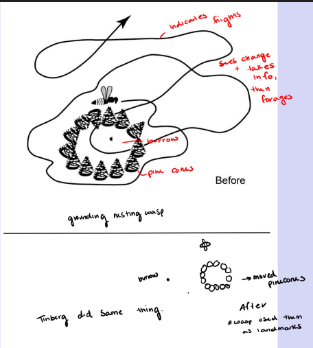
Researchers conducted a series of trials where they altered the surrounding landscape (by removing pine cones) and observed the bees' navigation patterns, demonstrating how quickly they lost their ability to return to their original burrow. Wasps were using the pinecones as a landmark.
Landmarks in Navigation
Use of Landmarks (We can get…):
Direction information: Assessing the course to navigate using landmarks.
Distance information: Estimating the proximity of landmarks during navigation.
I.e: the CN tower
Vector Navigation
Definition: Triangulation method finds the location of a goal using only directions (or bearings) from landmarks.
Mechanism:
Bearings from two landmarks can fix the location; three landmarks reduces possible error (more than 3, doesn’t really help)
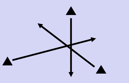
Allows us to compare distance and direction information
Note - a single vector is triangle and arrow
Migration Example:
*Note: This isn’t the full explanatory power for migration.
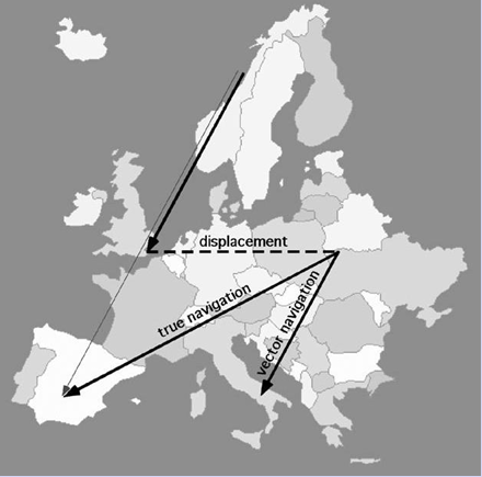
Example: Following displacement - Juvenile starlings (travelling from Norway) utilize vector navigation. Experienced starlings exhibit “true” navigation.
True Navigation = Depends on experience and memory. Must have both map and compass components.
If using vector navigation, would keep using vector even if displaced
Path Integration
Path integration = A method of orientation that uses only self-generated or “idiothetic” (internally generates) information. Integrates:
Vestibular info from rotation and motion
Proprioceptive feedback from limbs and muscles
Motor output to limbs and muscles (i.e: when you walk past your car in a parking lot and know that you’ve gone too far).
By maintaining a record of distances and changes in direction during an outward journey, an animal can calculate a homeward vector at all points on the outward path. Returning home requires only following this vector (direction and distance) back to start of the outward path.
Cataglyphus Ant Behaviour:
Found that this desert ant uses path integration effectively for returning to nests.
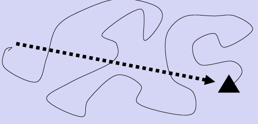
Foraging - take winding paths but when they want to home, they just go straight home.
Experiment
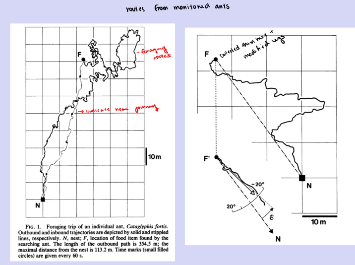
Researchers modified the legs of ants.
Treatments included; normal, stilts (extended legs) and stumps (amputated/shortened lengths)
Stilts wen past their nest site
Stumps took shorter steps and covered less distance.
Discovered they have an internal pedometer (counts steps taken)
Cognitive Maps
Tolman (1886-1959)
Cognitive maps in rats (in mazes) and men (1948)
Found that rats can navigate using cognitive maps by taking novel shortcuts.
Definition:
A cognitive map = Is a representation of the environment which indicates the routes, paths and environmental relationships that an animal uses in making decisions about where to move.
Gould (1986): Suggested honeybees also possess cognitive maps.
Do animals have cognitive maps?
Andrew T. D. Bennett argued that cognitive maps shouldn’t be used as there can be 2 definitions of cognitive maps.
Sensu Tolman, O'Keefe and Nadel:
Cognitive map is a powerful memory of landmarks which allows novel-short cutting to occur.
Sensu Gallistel:
A cognitive map is any representation of space held by an animal.
“no animal has been conclusively shown to have a cognitive map. Owing to the repeated inability of experimenters to eliminate these simpler explanations over at least 15 years, and the confusion caused by the numerous contradictory definitions of a cognitive map, I argue that the cognitive map is no longer a useful hypothesis for elucidating the spatial behaviours of animals and that use of the term should be avoided”
Challenges in Cognitive Map Theory
Andrew T. D. Bennett: Argues that no animal has been conclusively shown to have a cognitive map as per Tolman's definition.
Simpler explanations for navigation exist, which challenge the cognitive map hypothesis.
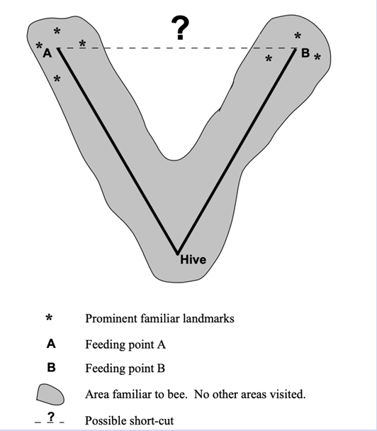
Landscape with visible landmarks, could use to get them to A? Thus the argument is…
For it to be a cognitive map, landmark associated with A while at B can’t be visible. If it is then can’t say for sure that it’s a cognitive map.
Solution - If one was blocked off, they would take a new novel route. If not cognitive map, will go back to the hive.
The Novel Shortcut Method
Novel shortcut method = Is a test for use of a cognitive map to infer spatial relations. This method tests whether an animal has experience traveling from A to B and from A to C can infer the spatial relation between B and C.
This method requires proof of:
The shortcut is novel (this is a problem with lots of rat maze work)
Note: There’s a difference between novel or favorite route
There are no landmarks at one site that are visible from the other
Path integration isn’t involved
A.T.D. Bennett concluded, in a review of previous research, there have been NO tests of the cognitive map theory that rule out all 3 alternatives.