APHG Unit 6: Cities and Urban Land Use
Akshara Murugappan 3/21/2026
6.1 Origin and Influences of Urbanization
Site - Climate, natural resources, absolute location; Characteristics that are a specific location.
Determine what types of activities will happen at a location or where a settlement will be located.
The site of the fertile crescent determined its becoming into a catalyst of the first agricultural revolution.
Mesopotamia’s access to fresh water and arable land allowed for sedentary agriculture to begin and remain stable thus allowing for the development of hierarchy and complex civilization
Situation - Roads, rivers, relative location; Locations surrounding a place (Connections between one place to another), impacts the development of a place. Describes a place in relation to other geographic features or places around it.
As transportation methods improve, it allows for people and places to connect more easily, allows for increase in the amount of goods and services being exchanged.
In the United States, the inter-state system creating convenience in travel between cities but also increase in suburbanization and urban sprawl
Urban Sprawl is the expansion of an urban or suburban area into the surrounding coutryside.
more people in suburbs = decline in economic opportunities in urban areas: businesses moved to suburbs to meet convenience of both workers and customers
also led to more reliance on automobiles rather than public transportation thus increasing air pollution
city specialization in services + implementation of urban policies and sustainable practices
changes in communication and technology impact spatial patterns in urban landscapes,
led people to move out of downtown areas in favor of working remotely and businesses questioning office space investment in CBDs
The absence of these people in CBDs has a direct affect on surrounding services and commodities, i.e. bars and roads
economic development: as society advances economically, more people migrate to urban areas in favor of economic opportunity, thus increasing population density, rent, home prices and essential affordability.
Cities unable to develop infrastructure to match the needs of residents + migrants, risk the creation of informal settlements
As development occurs, the TFR will likely decrease.
The TFR (total fertility rate) is the average number of children a woman will have during her lifetime.
Most urban areas grow more through migration when compared to natural births
Different govt. policies, regulations and taxes have economic affects on residents.
As residents struggle with affordability of land and rent, price ceilings may be implemented.
Price ceilings are govt. imposed limits on the price of a product or service with the goal being to reduce its price.
Price ceilings can have the unintended consequence of creating shortages as businesses may reduce production of the good or service since they no longer can charge as much and an essential loss in revenue
As cities expand, they expand the services they offer to their residents, driving economic and social growth but also costs the govt. more to maintain. Leading to higher taxes in urban areas, the govt. might offer certain tax breaks or incentives for businesses and people to move to an urban area to increase urban opportunity.
Practice Questions
How have advancements in transportation and communication changed where people are living?
a. We are now seeing more people want to live in the CBD of a city
b. Core countries are starting to see a counter urbanization movement, which is increasing the population in rural areas
c. Goods and services are becoming more centralized around a city, which is forcing people to travel longer distances for them
d. Cities in the semi-periphery and periphery countries are decreasing as the majority of their population leave to live in the suburbs
e. Large interstate systems decrease the amount of interaction between different settlements and cities
Which of the following statements is not true?
a. Traditionally the TFR of a society decreases as the urbanization rate increases
b. Site factors connect with relative location and situation factors connect with absolute location
c. The interstate system connected cities around the United States, which increased urban sprawl
d. Urban areas traditionally offer more economic opportunity when compared to rural
e. Mesopotamia is one of the six hearths of urbanization
Which of the policies listed below do not have an impact on the affordability of an urban area
a. Implementing a price ceiling on rent to make rent more affordable
b. Increasing taxes to help pay for new forms of public transportation
c. Offering tax breaks for businesses to motivate them to relocate into the urban area
d. Creating growth boundaries to prevent urban sprawl and increase the density of the urban area
e. All of the answers impact the affordability of an urban area
Advancements in communication and technology have…
a. Decreased the amount of urban sprawl and increased the population density in the CBD
b. Increased the amount of distance decay experienced between different places
c. Created more environmentally sustainable cities in countries around the world
d. Increased the amount of people living in the suburbs
e. Made urban areas less efficient and productive
Which of the following would be an example of a situation factor
a. The amount of raw materials
b. T he soil quality
c. The climate
d. The proximity to other places
e. The amount of freshwater
What is needed in order for a society to have job specialization
a. Food surplus
b. New ideas
c. Globalization
d. Trade
e. Industrial Revolution
6.2 Urban Settlements Around The World
more and more people are leaving rural areas for urban areas. 2007 was the first time that there were more people living in urban areas than rural. It is projected that by 2050 more than 2/3 of the world population will live in urban areas
Urbanization is the migration of people from rural to urban areas.
Megacity is a city with 10 million or more residents
Metacity is a city with 20 million or more residents
Today many of the worlds most populous megacities are located in core countries, but this trend is not predicted to last according to projections depicting the most populous megacities and metacities to be in periphery and semi-periphery countries due to global migration patterns and birth rates.
An example being Africa expecting to double its population by 2050 with the fastest urban growth rates in the world matched by declining birth rates in core countries.
Core Countries have industrialized and have the most advanced economies
Semi Periphery Countries have emerging economies that are industrializing
Periphery Countries rely heavily on the exportation of raw resources and are less economically developed.
Increased city population density increases the demand for fresh water, housing, food, electricity, use of sewer systems, roads, public transport services.
When growth rates of a population cannot be met by the infrastructure of the city leading to shortages, unequal distribution of different goods and services, an example being the creation of informal settlements.
Informal Settlements are housing and residential areas that have been built without legal authorization, they often lack basic infrastructure, services, and legal protection.
Many core countries are experiencing counter-urbanization and suburbanization.
Leading to the development of boomburb, exurbs and edge cities.
Boomburbs are rapidly growing suburban cities that have developed their own unique identities
Exurbs are settlements that exist outside of a suburban area but remain connected to the metro area. They typically have a low population density, larger lot size, and less goods/services
Individuals who are residents of exurbs will mostly receive their goods or services from boomburbs or edge cities rather than commuting to a CBD. Residents are also more likely to work from home.
Edge Cities are settlements that have their own economic district and is located on the outskirts of a city/near a beltway or major highway. They often have a high concentration of businesses, shopping centers and different goods/services.
As urban sprawl continues to happen, urban decentralization may occur, the movement of a population away from an urban areas traditional core to peripheral areas, resulting in power and money shifting more to the peripheral areas.
Because of bid rent theory, nearer to the CBD expansion of buildings is vertical, and density of buildings and homes are increased when compared to further away from the CBD where expansion occurs horizontally and homes are more spaced out, with front yards and back yards.
Countries in the periphery and semi-peripihery are more likely to have high rates of urbanization where core countries face counter urbanization and suburbanization.
Practice Questions
Identify the false statement
a. Megacities have more than 10 million people living in them
b. Metacities are uban areas with more than 20 million residents
c. Many of the world’s most populous metacities and megacities are expected to be in periphery and semi-periphery countries
d. Megacities and metacities are traditionally only located in core countries and are rare in developing regions
e. Today more people reside in urban areas when compared to rural areas
What is urban decentralization
a. the movement of a population away from an urban area’s traditional core to peripheral areas
b. the movement of a population away from rural areas to urban areas
c. the movement of a population from one state to another
e. the movement of businesses from one state to the peripheral area in another state
What is a common challenge faced by megacities and metacities
a. lack of job opportunities
b. limited access to education
c. limited access to healthcare services
d. overcrowding and informal settlements
e. lack of goods and services
A _____ is a settlement that is located outside a suburban area, but remains connected to surrounding settlements.
a. Boomburb
b. Exurb
c. Edge city
d. Urban area
e. Metacity
____ are settlements that have their own economic district and are most commonly located on the outskirts of a city near a beltway.
a. boomburbs
b. exurbs
c. edge cities
d. urban areas
e. metacities
6.3 World Cities and Hierarchical Diffusion
globalization has led to the establishment of an urban hierarchy
World Cities (Global Cities) - A city that is connected to other cities around the world through a series of networks, these cities have significant influence on global politics, economics, and culture.
traditionally connected to global markets
connected to other cities via networks, i.e, communication, transportation, manufacturing, banking
diffuses trends, goods, ideas, etc via hierarchical diffusion globally
have more diverse populations
world cities collaborate with one another, sharing designs and operations to try and solve larger scale problems
Examples: New York, London, Paris, Tokyo
Practice Questions
Which of the following is not true about world cities
a. They are at the top of the urban hierarchy
b. They are connected through a variety of global linkages
c. They facilitate the diffusion of different cultural traits around the world
d. They often have a high urban density but lack a variety of goods and services
e. They impact countries around the world
Which of the following is a challenge faced by cities in a globalized world
a. Losing the cities local cultural identity
b. Lacking different goods and services
c. Not having enough economic opportunities for residents
d. Lacking new ideas and innovative urban planning methods
e. A reduction in capital preventing urban expansion
What type of diffusion occurs between global cities and settlements that surround them?
a. Contagious
b. Stimulus
c. Expansion
d. Reverse Hierarchical
e. Hierarchical
Which of the following would not be an example of a world city
a. New York
b. Paris
c. Tokyo
d. London
e. Orlando
Which of the following can you find in a world city?
a. Stock exchanges
b. Multinational corporations
c. Different embassies
d. All of the above
e. None of the above
6.4 The Central Place Theory and Urban Hierarchy
How size of a settlement impacts classifications of cities.
Generally, countries either follow the Primate City Rule or the Rank Size Rule
Primate City Rule in which a city that has twice the population of the next largest city. The primate city having significant political, economic, and social control over the rest of the country.
usually has at least twice the population of the second largest city within a state
most opportunities are located within the primate city
concentration of goods and services within primate city leads to residents of outside settlements having to commute
unequal economic development causes devolutionary pressure
country is dependent on the success of one city - grounds for future problems
Devolution is the transfer of power from a national government to regional governments, power is broken up and spread between lower organizations
Example: Mexico City, Mexico and Seoul South Korea
Rank Size Rule in which the population of a settlement ranked n will be 1/nth of the size of the largest settlement. i.e. second largest settlement will have half the population of the largest , the third largest will have one-third the population, and so on)
pn=p1/pn
population of city = population of largest city / rank size of the city
reduces commute time for citizens to access goods and services
less economic pressure on one city = less devolutionary pressure
less economically dependent on a singular city = widespread economic development and growth
Gravity Model the larger a settlement is the more pull factors it has = more migration
memory trick: more mass = more gravitational pull
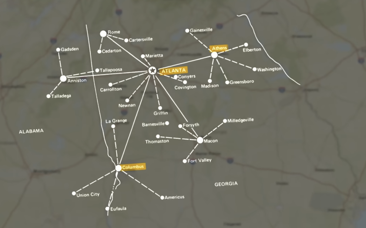
Christaller’s Central Place Theory - seeks to explain distribution pattern of cities and towns concerning size.
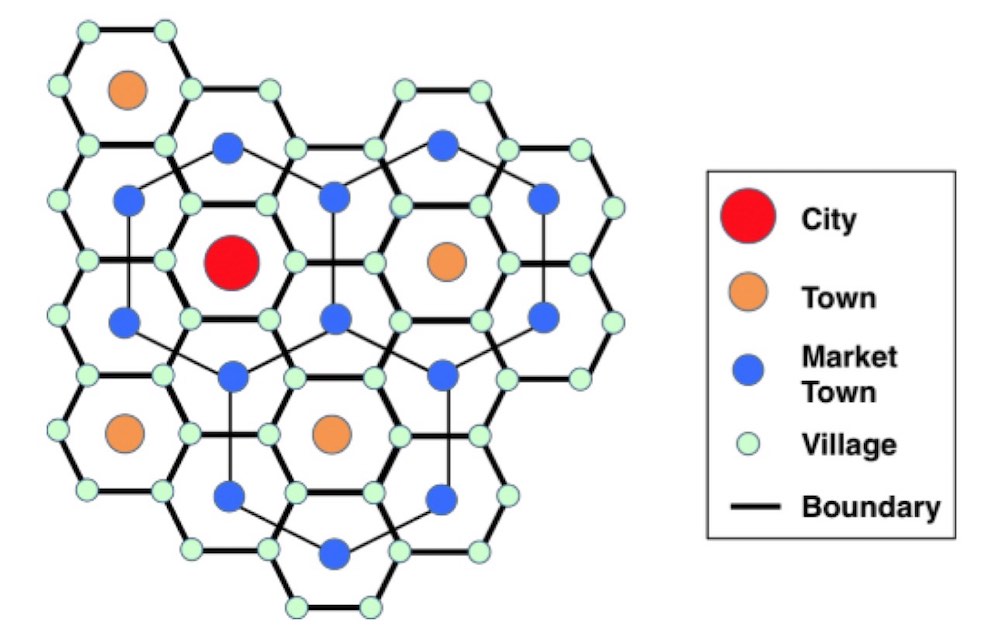
hexagons are used because they do not over lap but cover all areas when linked together
Threshold is the minimum number of people that are required to support any good or service
Range is the maximum distance that consumer is willing to travel for a certain good or service
Unique, specialized, and important goods/services have greater ranges than those that are common, general, and easily replicable
In application of range, relative distance is prioritized over absolute.
smaller settlements may not be able to afford certain goods or services that are considered necessary, thus they become dependent on other settlements
cities will often have the largest variety of specialized goods and services when compared to market towns and towns that will have more generalized.
Spatial layouts of cities are dependent on the size of the settlement as well as locations of surrounding settlements
the larger a settlement, the farther away it can be from another major urban area
the closer a settlement the closer it has to be to another major urban area
central place theory is especially applicable to the American South
also Atlanta, Georgia
Practice Questions
Which of the following is not true about a society that follows the primate city rule
a. The country is more likely to have unequal economic development
b. The country is most likely dependent on one major city for their economic prosperity
c. Citizens of the country that do not live in the primate city most likely lack many goods and services
d. The second largest city in the county is significantly smaller than the largest city
e. A country with a primate city most likely has different resources, goods/services dispersed through the country
Which of the following is a key assumption of the central place theory?
a. Due to advancements in technology consumers will always choose the best service instead of the closest service
b. The range of goods and services supplied by a center increases as the size increases
c. The urban hierarchy is determined by the density of the population in the region divided by the distance from the next urban area
d. Any business or settlement that can meet its threshold and rand requirements will succeed
e. Investments in a cities infrastructure increases the importance of an urban area and reduces the chance of exurbs and boomburbs existing
A society that has a variety of larger settlements with the second largest settlemetn having ½ the population of the largest settlement and the third larges settlement having 1/3 the population of the largest settlement is following the _______.
a. Primate city rule
b. Gravity Model
c. Urban Hierarchy
d. Central Place Theory
e. Rank Size Rule
Which of the following answers is not factual
a. Counties that follow the rank size rule generally have their goods and services more evenly dispersed throughout society
b. The larger a settlement is the more pull factors it has, often resulting in more people migrating to the settlement
c. Traditionally the more unique, important or specialized a good/service is the larger its range will be
d. The Central Place Theory states that the spacing between different services and settlements is unstructured and random
e. Threshold is the minimum number of people required to support the production/distribution of any good/service.
What are the two variables that the Gravity Model uses?
a. Distance and economic output of a city
b. Range and threshold of a city or business/service
c. The amount of economic opportunities and social opportunities
d. Population size and distance
e. Type of government and population size
Which of the following businesses/services is most likely to have the smallest range
a. Burger King
b. Cancer treatment center
c. International airport
d. Radio station
e. Shopping mall
6.5 Urban Models
there are more residential zones farther from the CBD
Burgess Concentric Model - based on Chicago, Illinois 1920s
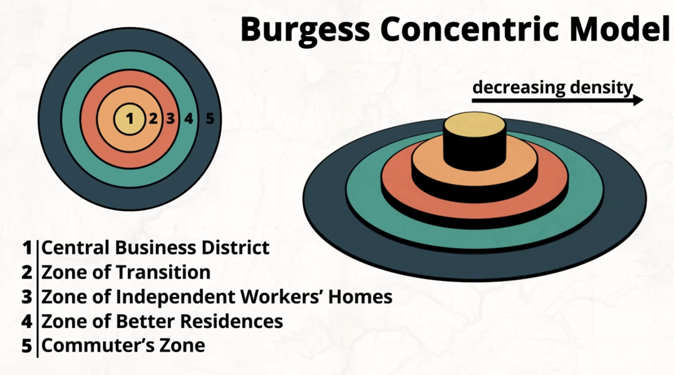
CBD (Central Business District) is surrounded by older homes, newer developments are farthest from the CBD
Zone of Transition Lower income residents found and industries - unique to US because in other countries, wealthier residents are nearer to the CBD.
Zone of Independent Worker’s Homes are where the working class reside, traditionally older homes occupied by workers of the CBD
Zone of Better Residences, dispersed single family homes
Commuter’s Zone, live outside city limits but commute to city for work
parts of model are becoming outdated due to globalization, change in production of goods/services, urban renewal policies, gentrification
Urban renewal = government-led rebuilding of cities to make them more modern, functional, and economically active
Gentrification is the process where a neighborhood—often a lower-income or historically marginalized area—changes as wealthier people move in.
Hoyt Sector Model
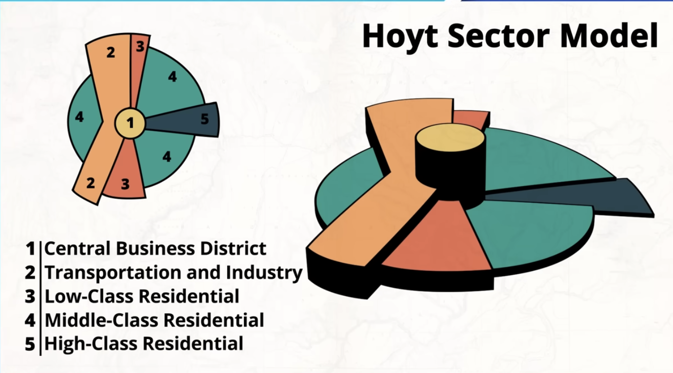
more focused on transportation
city develops in sectors.
businesses and industries will be located near transportation routes allowing easier accessibility for consumers and delivery of components for production
outdated due to changes in transportation - CBD less important as more migration towards boomburgs, exurbs, and edge cities
Multiple Nuclei Model (Harris - Ullman)
created around 1945
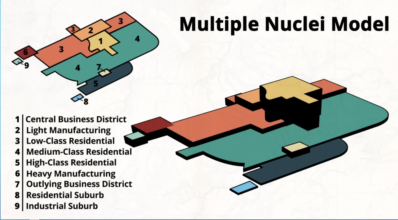
tries to explain how cities have changed due to advancements in transportation and communication
each node attracts specific people, businesses and services and repels other groups.
Galactic (Peripheral) Model
developed in the 1960s focused on a post-industrial settlement
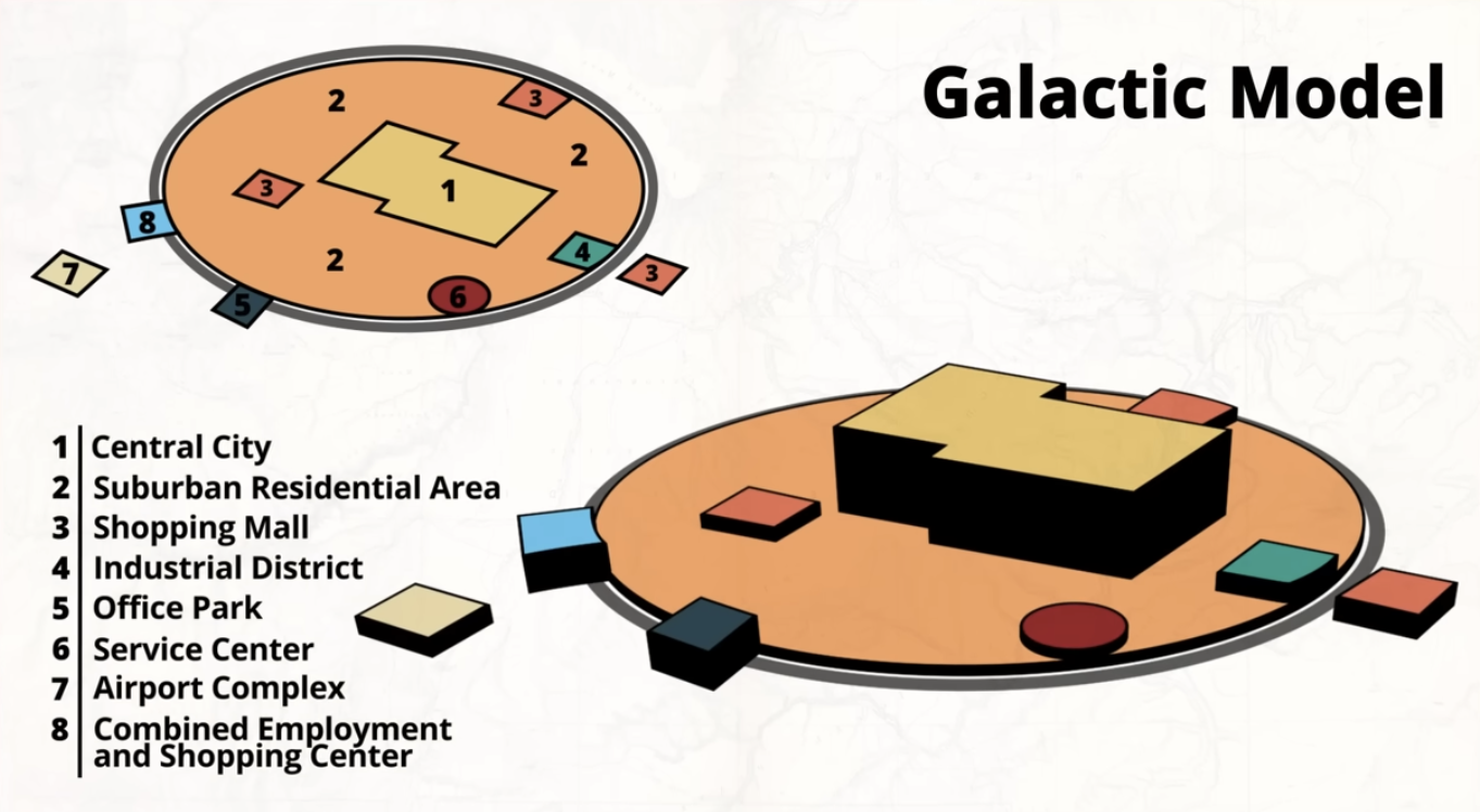
economy is more service based than manufacturing
accounts for technology and communication
acknowledges edge cities
resembled by Atlanta
Latin America City Model
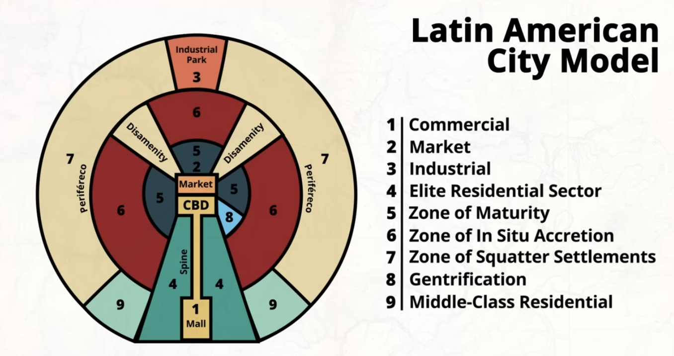
impact of European colonization, central plaza + church
spine extends from CBD consisting of wealthier residents and high end commercial activity
Zone of Maturity consists of older homes and buildings which may have experienced gentrification throughout time
6,7 middle + low income housing
Disamenity = extreme poverty + informal settlements
Middle class residential right outside high end residential
Sub-Saharan Africa City Model
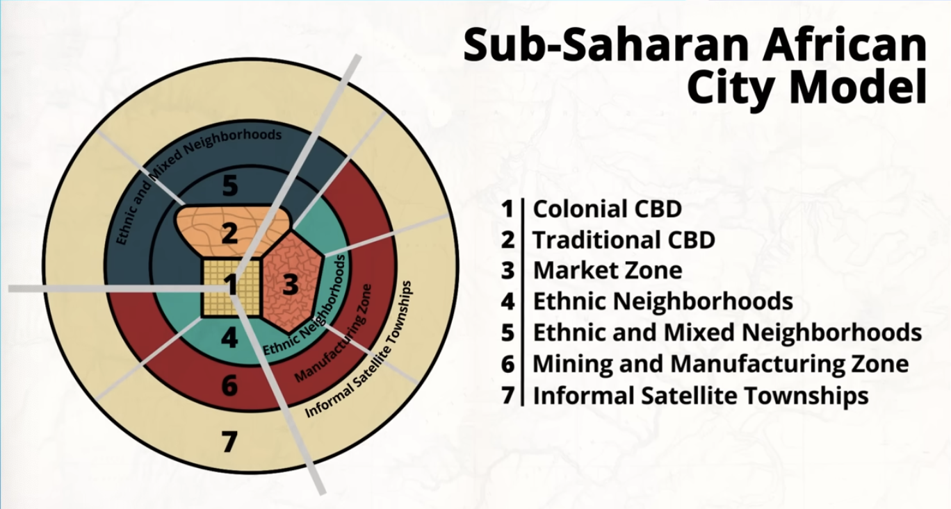
impacted by colonization
Cities are fragmented and divided, with different sections based on history, ethnicity, and economic status.
rapid urbanization
inequality is very visible
informal economy is very present
Apartheid = legal separation of races, where nonwhite populations were systematically oppressed
Southeast Asian City Model
city based around a port in the place of a CBD
due to geography of the region
many of these cities developed as trading posts due to colonialism
western commercial zone - modern businesses, banks, shopping centers
influenced by western/global culture
neighborhoods based on ethnicity - alien zones
mixed land use - residential, small businesses, industry, very dense and chaotic
peripheral squatter - informal housing on outskirts
examples: Bangkok, Jakarta, Manila
Practice Questions
Which of the following is not true about the Sub-Saharan African city model
a. Located in the colonial CBD is mixed use buildings, skyscrapers and a grid pattern
b. The spatial arrangement of major roads and local streets, as well as the presence of distinct ethnic neighborhoods, are legacies of the colonial era and the continued influence of apartheid
c. Shantytowns and squatter settlements are located on the outskirts of the city
d. The informal CBD consists of formal and informal economic activities, high rise buildings, and a grid pattern
e. The last ring in the Sub-Saharan African city model is informal satellite townships
Which of the following answers is not correct?
a. The Latin American city model consists of three distinct CBDs
b. European colonialism impacted both the Latin American city model and Sub-Saharan African city model
c. Rapid urbanization has caused both the Latin American city model and Sub-Saharan African city model to see the rise of informal settlements
d. The galactic model accounts for advancements in technology and transportation
e. The Burgess concentric model has become outdated due to globalization, changes in the production or different goods and services, and due to changing urban policies
Which of the following best describes the disamenity zone?
a. A part of the city that contains wealthier individuals who work in the CBD
b. The manufacturing area of a city often located near a beltway and connected to the surrounding periphery area
c. A part of the city that contains middle class residents who often live near an exurb
d. The commercial area of a city that contains the most retail stores
e. An area within the city with high poverty rates and limited services/amenities
City X was organized around a port rather than a CBD, with diverse economic zones extending from the port and a government district located nearby. Which urban model best represents city X?
a. Galactic
b. Concentric
c. Sector
d. Latin American
e. Southeast Asian
According to the bid-rent theory, which of the following is most likely to be located closest to the city center?
a. Low income housing
b. High end shopping districts
c. Industrial manufacturing plants
d. Agricultural farmland
e. Properties with a larger lot size
Which urban model emphasizes the role of transportation in shaping the city?
a. Concentric zone model
b. Multiple nuclei model
c. Sector model
d. Latin American city model
e. Sub-Saharan African city model
6.6 Urban Density and Land Use Patterns
Density Gradient is a gradual change in the density of an urban area from the center to the periphery
high density area residents rely on public transportation with a greater disposal of specialized goods and services
poor urban planning may result in inadequate infrastructure and food desserts
medium density areas are in proximity to high density areas but maintain a semi-suburban feel with relative dispersion. More diversity in types of homes,
low density areas have more green spaces and horizontal expansion when compared to vertical in higher density areas. Require more land, more dependence on personal vehicles and increased commute times
Practice Questions
Which of the following best describes the density gradient of a city
a. A change in the maount of public transportation that is offered as you move away from the CBD
b. The change in land value as you move away from the CBD
c. The change in building density and population density as you move away from the CBD
d. A change in the location of different services and agricultural production as you get closer to the CBD
e. None of the above
How is urban sprawl impacting the spatial layout and land use patterns of cities and their surrounding areas?
a. It is creating more green spaces in high-density and medium density areas
b. It is reducing the amount of traffic on the road, which allows for more land to be priortized for sustainable development
c. It decreases the amount of public transportation options in suburban areas
d. It decreases the population density near the CBD and reshapes the density gradient of an urban area
e. It reduces the amount of economic opportunities in the low-density areas
Which of the following statements is not true?
a. Low density areas often require more land for the same number of residents as high density areas
b. Buildings and homes in low density areas expand horizontally while building in high density areas expand vertically
c. It is common to find multi family homes with a small front and backyard in medium density areas
d. Poor urban planning can often lead to food deserts and unequal economic development in an area
e. The closer you get to the CBD the more likely it is that you will find duplexes, town homes and triplexes
Which of the following would be a reason why skyscrapers are most often found in high density areas
a. To create better views for residents
b. To incorporate modern architecture into the city’s cultural landscape
c. to optimize space, reduce land costs, and improve efficiency
d. To increase the amount of urban sprawl
e. To decrease the amount of gentrification in an area
Which of the following explains why retail stores are often found on the ground level in mixed use buildings?
a. It allows for more room in other zones
b. It reduces the amount of sound pollution from the street
c. It decreases the change in the density gradient
d. IT increases the amount of foot traffic in a store since it is more convenient for shoppers
e. It maximizes the amount of online sales by allowing quick shipments from the store
6.7 Infrastructure Impact on Urban Areas
Infrastructure is the physical and organizational structures and facilities that are needed for a society, system, or organization to function.
CBD businesses are moving out of high density areas
As people move away from CBD’s, businesses follow leading to urban sprawl due to the presence of competent infrastructure such as the interstate system.
An investment in better infrastructure gives a city more opportunity for development.
As development occur green spaces can be replaced by concrete and expanding suburban footprint.
High reliance on automobiles = air pollution as people spend more time driving since they are spread farther apart.
As cities expand infrastructure costs increase + cost of maintenance as infrastructure faces elements = higher operation costs
lack of infrastructure maintenance can lead to failure which has the prospect to cause serious harm
Infrastructure maintenance may cause debates creating political turmoil
New infrastructure must consider new advancements in technology.
Practice Questions
How did the creation of the interstate system impact urban areas?
a. It made it easier and quicker for people to travel between different cities, which increased the amount of urban sprawl
b. It made it harder and more expensive for people to travel between different cities, which decreased the amount of urban sprawl
c. It increased the amount of govt. spending and increased the amount of taxes people had to pay, but had little to no impact on where people lived
d. It increased the connectivity between cities in the same region, but isolated cities in different parts of the country
e. It reduced people’s dependence on automobiles and increased the amount of public transportation
All of the following answers are true except for….
a. If cities expand public transportation services outward from the urban core, it will increase the cost of operating the city and lead to more urban sprawl
b. Investing in the infrastructure of the internet can help individuals in underserved areas get access to essential services
c. Societies that continue to invest in their infrastructure and maintain it often see increased economic development
d. Infrastructure is expensive to build and costly to maintain
e. Only the federal government can decide where to build new infrastructure in an area
When cities have quality infrastructure that is easily accessible it….
a. Decreases the amount of economic growth in the center of the city
b. Reduces the standard of living for individuals living in the periphery
c. Creates social segregation and stagnation across the urban area
d. Allows for more economic growth and social development for all residents
e. Reduces the amount of govt. spending in an urban area
Which of the following is not infrastructure
a. Demographics of a city
b. A local hospital
c. Bus stations
d. Water and sewage pipes
e. A police station
6.8 Urban Policies and Sustainment
Sustainability is the use of the Earth’s resources in a way that ensures those resources will still be available in the future
Urban sustainability is the urban environment that promotes stable economic and social growth while also promoting environmental sustainability
economic sustainability can be seen in cities that allow for equal opportunity economic growth and reduces negative impact on the environment
support small businesses, local development, entrepreneurs
Social sustainability is the providing of safe and inclusive communities for all residents, ensuring necessary infrastructure.
Goal: High standard of living without compromising sustainability
Sustainable Designing Policies
zoning policies - incorporate mixed land use development into urban areas
mixed land use areas allow for the mixing of commercial, residential, and even industrial zones creating neighborhoods that eliminate needs of commute. Thus promoting walkable cities.
Transit Oriented Development is urban planning that strategically locates public transit stations throughout a city to reduce dependence on automobiles and provide convenient and accessible public transportation options
Smart Growth Policies are urban policies that seek to reduce urban sprawl and protect farmland surrounding the city - achieves this goal by promoting mixed use development, public transportation, and green areas. keep area compact and walkable
can lead to the development of greenbelts which are undeveloped areas of land in close proximity to urban areas in order to preserve the environment, provide a buffer between rural and urban land, prevent urban sprawl
examples: London, Tokyo
New Urbanism is urban planning that seeks to create compact and walkable cities that are sustainable and socially connected. They have a greater focus on community design which leads to more pedestrian friendly neighborhoods with integrated economic classes through a mixture of housing types and public spaces. focus on architecture and city design, reflects European urban life,
Smart growth policies can cause an increase in the cost of living and even de fact segregation
De Facto Segregation is the separation of people along racial, ethnic, or socioeconomic lines that are not enforced nor regulated by laws or regulations.
Slow Growth Cities are urban areas that promote sustainable growth by limiting new development in the periphery of the city. Goal to reduce urban sprawl and preserve open spaces and green areas
Growth Boundary are put in place to control urban sprawl, preventing development outside the boundary
Infill development is building within an existing developed area on land that is unused or underdeveloped, in a way that does not expand the cities foot print outward.
Brownfield is an abandoned property that was previously used for industrial or commercial use and is contaminated with hazardous pollutants.
Smart cities utilize technology and data to reduce inefficiencies, optimize resource usage, and improve the quality of life for its residents.
Practice Questions
Cities that have a growth boundary in place will see all of the following except for…
a. An increase in their population density
b. More infill development and new land use patterns inside the urban area
c. Increased home prices and an increase in the cost of land inside the boundary
d. Less investment in public transportation and less focus on redeveloping brownfields
e. Reduction in the amount of farmland repurposed for urban use
The image below is an example of …
a. Greenbelt
b. New Urbanism
c. De Facto Segregation
d. Transit oriented development
e. Brownfields
Which of the following answers is not true?
a. Gentrification helps preserve historic buildings and neighborhoods
b. One cause for gentrification is improved public services and infrastructure in urban ares
c. Gentrification often leads to lower income residents becoming displaced
d. When cities renovate, rebuild, and revitalize an urban area, it can make the area more attractive to affluent residents which can lead to gentrification
e. Gentrification impacts the social equity, economic growth, and cultural diversity of an area
Which of the following would best match with sustainability
a. Society and the environment shape each other
b. Society meets their own needs and wants without hindering future generations’ ability to do the same
c. Cultures can shape the environment around their needs
d. The ability to create more resources allows for more productive of societiese
e. People will exploit some resources in hopes of preserving others.
6.9 Types of Urban Data
Quantitative and qualitative data are used by govt and private officials to make informed decisions.
Practice Questions
Which of the following is an example of how the govt can use qualitative data to improve the city
a. City officials look at traffic accidents to identify which intersections should be reworked to reduce traffic into the city
b. City officials can analyze different crime reports to better understand what residents want prioritized in a city’s urban policy
c. City officials can hold a town hall to better understand what residents want prioritized in a city’s urban policy
d. City officials often use census data to understand which parts of a city are growing and which are shrinking.
e. City officials use demographic data to determine which parts of a city need a new elementary school.
Which of the following is an example of quantitative data?
a. Presidential approval rating
b. Social media analysis
c. Focus group discussion
d. Public opinion of urban policies
e. Median income of an urban area
Which of the following is not an example of quantitative data that a business might collect?
a. Sales figures
b. Unemployment rate of a city
c. Average age of a neighborhood
d. Focus group discussions
e. Median income in a city
How can a business use census data
a. Analyze market demand for a product
b. Gain insight into areas that would be favorable for them to locate
c. Understand the different political views of an area
d. Identify which neighborhoods need to be revitalized
e. Gain insight into past urban policies and their impact on situation factors
6.10 The Impact of Segregation and Urban Challenges
In the United States cities struggle with racial and economic segregation
impact from historic policies, such as Jim Crow are still visible in the shape of current cities
May also be due to de facto segregation
Redlining is a discriminatory practice where banks refuse to provide loans to people who live in certain neighborhoods, areas that were deemed high risk and not given loans were typically minority neighborhoods.
Redlining hurt the ability of minority groups to develop generational wealth through investments and home ownership.
Blockbusting was a discriminatory practice where real estate agents use misinformation about minority communities moving into a neighborhood to motivate white homeowners to sell their home at a lower price so they can then resell it at a higher price to a minority buyer who was previously excluded from the area.
White Flight is a phenomenon in which white residents migrate out of an urban area to a suburban area in large numbers
Urban Blight/Decay are homes that hold close to no value due to being abandoned, vandalized, or stripped.
Environmental Injustice The disproportionate distribution of environmental hazards among different social groups. Environmental hazards and pollutants are most commonly found near marginalized and vulnerable communities.
Disamenity Zones are areas or regions within a city that lack public services, quality infrastructure and have a higher concentration of crime, poverty, and sometimes squatter settlements.
can be caused by deinstustrialization
Deindustrialization is the decline of industrial production and manufacturing in an economy or region.
Disamenity zones are also prone to informal settlements.
Informal settlements are residential areas that have been built without legal authorization and often lack basic infrstructure, services, and legal protection.
Informal Economy includes activities and jobs that are not regulated or protected by the govt such as street vending, domestic work and unregistered small businesses
Revitalization programs are put in place to attract people back to an area by promoting economic growth and by creating new opportunities for residents.
Inclusionary Zones are areas where there are local policies in place, legal requiremetns, or incentives for developers to create affordable housing for lower income families and thus help create mixed income communities.
Revitalization can also lead to gentrification
Bureaucracy An organization that has multiple levels which all seek to carry out a specific task
Municipalities are local government units created by a state or national govt, such as towns, cities, villages, etc.
Eminent Domain is the right of the government to take private property for public use
Federal does not have the power to direct cities or create urban policies for cities but can influence city development by using financial incentives
State can directly influence local city planning
Regional work to coordinate between different municipalities within a region, focus on transportation planning, economic development and environmental policies for a region
Local city governments are in charge of the day to day life inside city limits whereas county governments control the hinterland and unincorporated county
Special District are units of govt that provide specific services for residents in the area
Practice Questions
Which of the following best describes deindustrialization
a. A decline of industrial production and manufacturing which ends up destroying the local economy that depended on those jobs
b. An increase in industrial production and manufacturing in an area resulting in the decline of service based jobs in the region
c. A change from service based jobs to automated jobs thus increasing unemployment in an area
d. The decline of service based jobs thus destroying the local economy that was dependent on those jobs
e. A phenomenon of jobs being outsourced to core countries instead of being located in the periphery or semi-periphery
Which of the best describes gentrification
a. Lower income individuals move into a neighborhood which end up reducing the property values in the area
b. Govt. officials pass blockbusting policies to remove low income individuals from an area in order to increase property values
c. Affluent individuals move into urban areas that have been revitalized causing property values to increase and lower income residents to become displaced
d. A phenomenon in which white residents migrate out of an urban area to a suburban area in large numbers
e. The process of redeveloping land that has been contaminated from previous industrial and commercial use
Which of the following best explains the concept of de facto segregation
a. The separation of people along racial, ethnic, or socioeconomic lines that is officially enforced by laws or regulations
b. The legal segregation of people based on their culture and their spoken language
c. The separation of people along racial, ethnic, or socioeconomic lines that is not officially enforced by law or regulations
d. The segregation of people based on their country of origin and immigration status
e. Economic and socioeconomic segregation that used to exist in a city, however
6.11 Challenges of Urban Sustainability
As urban sprawl occurs, it decreases the sustainability of an urban area
Ecological Footprint is the amount of land and resources that are used to support the population of a city.
As cities expand, they reduce biodiversity and increased pollution as well as resource depletion.
Extreme weather stresses cities as high energy demand may lead to blackouts and cold events result in grid failures, essentially causing higher costs, infrastructure strain and even potential loss of life.
Rapid urban overgrowth may also lead to sanitation issues such as sewage overload, water contamination, and poor trash collection.
Some solutions include smart growth policies that limit sprawl via green belts and growth boundaries. Infill development, brownfield redevelopment, and zoning laws.
Practice Questions
What does urban sprawl do to a city’s ecological footpring?
a. As urban sprawl occurs a city’s ecological footprint often decreases
b. As urban sprawl occurs, a city’s ecological footprint often increases
c. As urban sprawl occurs there is little to no change in a city’s ecological footprint
d. As urban sprawl occurs a city’s ecological footprint becomes obsolete
e. As urban sprawl occurs, a city’s ecological footprint starts to decrease but eventually increases again.
Which of the following statements is not true?
a. As cities expand they often end up decreasing the amount of biodiversity in an area
b. Climate change has created new challenges for urban areas such as increased demand on a city’s energy grid
c. Urban growth boundaries encourage infill development which helps decrease the amount of urban sprawl
d. The expansion of public services away from the urban core often leads to increased urban sprawl
e. Mixed use development is traditionally only found in urban sprawl communities.
___ is when cities focus on building iside an urban area on land that is currently unused or underdeveloped in ways that do not expand the city’s footprint outward
a. Growth boundaries
b. brownfield
c. infill development
d. urban blight
e. disamenity
Which of the following best describes brownfields?
a. Land that has experiences urban blight and rot
b. Abandoned land that was polluted from previous industrial and commercial use
c. Arable land that is used for agricultural production
d. Suburban settlements that have been annexed by an urban area
e. Land that was previously farmland but was replaced by urban sprawl
Which of the following would best match with sustainability
a. Society and environment shape each other
b. Society meets their wants and needs without hindering future generations ability to do the same
c. Cultures can shape the environment around their needs
d. The ability to create more resources allows for a more productive society
e. People will exploit some resources in hopes of preserving others