Revision Sheet
Section 1: Types of Hazards (3.1)
Cyclones
A cyclone is a rapidly rotating storm that begins over tropical oceans.
Causes:
Ocean temperatures over 27 degrees Celsius.
Wind shear ( wind going in the same direction )
Strong Coriolis force ( force of the Earth’s rotation )
And a depth of at least 70km.
Characteristics:
Eye - The calm of the storm with light winds and clear skies.
Eye Wall - The most violent part of the storm with harsh winds and heavy rain.
Spiral Rain Bands - Bands of heavy, convective rain showers that spiral inwards towards the eye.
Distribution:
The Pacific Ocean generates the greatest number of tropical storms and cyclones.
The most powerful storms, sometimes called super typhoons, occur in the western Pacific.
The Indian Ocean is second in the total number of storms, and the Atlantic Ocean ranks third.
Measurement: Cyclones are measured using the Saffron Simpson scale.
Primary Effects
high wind speeds, which increase the cyclones power and are necessary for it to form.
Secondary Effects
tornadoes (caused by high wind shear and updrafts)
flooding (large water content pushed towards shore)
Volcanoes
A volcano is an opening in the earth’s crust where molten rock, magma, and ash are erupted onto the land.
Hotspot - Isolated areas with rising magma that lead to volcanic activity away from plate margins, any where there’s an active volcano.
Lava - Molten material erupted through a volcano or crack from inside Earth, onto its surface.
Chamber - Reservoir of magma in the volcano.
Crater - The dip at the top formed after the eruption.
Vent - The channel from the chamber for the magma to pass through to the surface.
Causes: Volcanoes are caused by convection currents in the Earth, allowing molten rock to be created and collected in a magma chamber and eventually released onto Earth’s surface.
Characteristics:
Shield Volcanoes (from constructive boundaries)Gentle Slope
Thin, runny magma
Main and side vent.
Composite Volcanoes (from subduction boundaries)
Crater
Vent (main pipe)
Side pipe
Clouds of ash and dust
Thick, viscous lava flow
Magma chamber
Volcanic bombs
( Shape of volcano also depends on amount of change since last eruption. )
Distribution:
Volcanoes mostly occur along plate boundaries.
They are highly concentrated in South American and Asian boundaries.
The ones away from the boundaries are at hotspots.
Near (or in) bodies of water.
Active - Erupted recently and likely to erupt again.
Dormant - Erupted in the past 2000 years, but not recently.
Extinct - Unlikely to erupt again, volcanic activity finished.Measurement: VEI ( Volcanic Explosivity Index )
Goes from 0-8 ( 0 = No explosive eruption, 8 = Mega volcano )
[ Non-explosive eruptions are the most common. Calm lava flows in huge amounts. ]
Based on lava and the type and amount of gas.
Primary Effects
pyroclastic flow - very fine ash and debris falling back onto earth’s surface.
volcanic bombs - a big, aerodynamic mass of partially molten rock released from volcanic eruptions of lava
lava flow - the flow of molten magma expelled from the earth that destroys everything in its path.
Secondary Effects
acid rainfall (rainfall mixed with, for example, sulfuric or nitric acid)
atmospheric ash fallout (ash falling back after explosion)
Earthquakes
An earthquake is the vibrations caused by earth movements at plate boundaries and major fault lines (crack’s in Earth’s surface) due to build ups of pressure.
Causes:
Characteristics: Earthquakes have a focus, a fault, seismic waves and wave fronts, and a fault scarp.
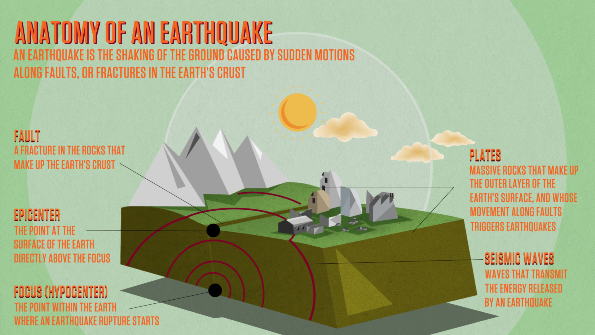
Distribution:
Earthquakes occur at plate boundaries and fault lines and are worst at destructive and conservative boundaries.
Deep and intermediate focus earthquakes are usually at subduction zones. (>300km)
Shallow focus earthquakes are usually at constructive and conservative zones. (<70km deep)
The longer a fault is locked (plates are stuck in place), the more pressure build up, the worse earthquake.Measurement: Earthquakes are measured using the Richter scale, the Mercalli scale, and the Moment magnitude scale.
Richter Scale - Uses a seismograph and goes up to level 10. It is logarithmic.
Mercalli Scale - Subjective and based on people’s observations/opinions. Up to 12.Moment Magnitude Scale - Most used by scientists, logarithmic, most accurate, takes into accounts physical characteristics (area of fault, amount of slip, etc.)
Magnitude - The strength of an earthquake is measured from the epicentre.
Intensity - Degree of shaking caused by the earthquake decreases with distance from the epicentre.
Primary Effects
the ground shaking from seismic waves
surface faulting from where the two plates interacted
Secondary Effects
landslides and rock falls from rocks cracking and breaking.
ground failure (landslides)
soil liquefaction (becomes more loose and less firm)
Section 2: Impact of Hazards (3.2)
Why do people live in hazardous areas?
Financial Reasons:
fertile soil for agriculture → profit from selling produce
expensive/valuable rocks are created → money from selling
money from tourism
free / extremely cheap geothermal energy
Non-Financial Reasons:
Lack of proper education leads to reluctance / unwillingness to leave a hazard zone.
No space elsewhere for the population living in hazardous areas.
Underestimating the danger of natural disasters.
Not wanting to uproot life / adjust to a new place.
Sentimental attachments - Such as religion or family members.
Factors affecting vulnerability
Social Factors:
education
gender (more men in construction jobs, for example)
population density (more people affected)
age (it’s easier for younger to escape)
Financial Factors:
levels of wealth/development
building styles/codes
access to technology (like warning systems)
insurance cover
Physical Factors:
Physical Geography (e.g. coastal lowlands that increase susceptibility to landslides and flooding.)
Natural Environment (e.g. warmer ocean surface temperatures can lead to increased wind speeds in tropical storms)
Section 3: Earthquakes (3.3)
Preparation for Earthquakes (p106-108)
idk i dont have the book
Short term responses
Long term responses