hazards resulting from tectonic processes
distribution
these occur around plate boundaries
the types of hazards depend on the movement of these plates ( destructive, constructive, conservative and collision)
if the vibrations of the earthquake are large then the impact will be large. the impact depends on the level of urbanisation of the area, as well as the level of preparedness of the country and the status of the country.
in LIC’s even though they might have frequent earthquakes they are still not able to help themselves and so they live with the conditions or rely on international aid and non profit organisations.
In an HIC’s because it is well develop they are able to cope with the damage and are likely to be well prepared too which minimises their impact and devastation even if the magnitude of the earthquake is large.
HIC’s also have the tech to be able to predict and monitor the movements so they are able to inform the people and evacuate them and also to prepare for the hazard.
LIC’s tend to have higher casualties due to the fact that they wont have adiquate rescources to do damage control and recovery
this can be shown in the park model of recovery


other factors also include time fact ( when the disaster took place)
national recovery budgets and if there is enough money and resources to recover
the area over which the event took place
secondary hazards
water sources are polluted
there is not enough shelter, food and clothing
there is a spike in water born disease
not enough medical care to treat everyone
travel links are blocked/ interrupted ( no one can go in or out) ( no aid coming into country)
From Tectonic Processes
Volcanoes and Earthquake Distribution
When describing distribution, use T(CLUES)EAM
Trends: loose/strong, positive/negative correlation → what are the plates doing in relation to one another?
(CLUES): clustered, linear, uneven, even, scattered
Evidence: use specific place names to support → what specific details can be given about the site
Anomalies: find features that disagree with the trend → what is unique about this movement?
Manipulate: make simple calculations if data present
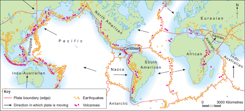
Earthquakes
Clear linear chains along plate boundaries (Mid-Atlantic Ridge)
Broad chains along subduction zones (Nazca/South American plate)
Few earthquake events not on boundaries, due to human activities or hotspots (Hawaiian Hot Spot)
Volcanoes
Strong bands of linear volcanoes along boundaries
¾ Earth’s volcanoes lie around Pacific Ring of Fire
Clustered volcanoes over hotspots (Hawaii)
Most intense along subduction zones
Hazards on Boundaries
Different boundaries produce different hazards.
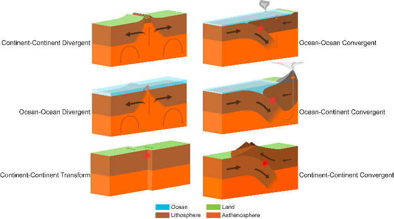
Conservative
Intense earthquakes due to intense friction along boundary (San-Andreas fault line)
No volcanic eruptions
Collision
Earthquakes due to collision and friction along boundary
No volcanic eruptions
Destructive
Shallow to deep earthquakes, inclined along the Benioff zone, where slab pull occurs
Explosive, ashy, viscous volcanic eruptions due to greater melting causing silica rich magma
Constructive
Moderate earthquakes as a result of weak oceanic crust being moved by volcanic intrusions, or by transform faults caused by different speeds of spreading along the boundary (Mid-Atlantic Ridge)
Fluid basaltic lava rises to form new oceanic crust
Hotspot Theory
Radioactive decay in Earth’s core causes uneven heat
Triggers intense heat transfer from core through mantle
Mantle only becomes in motion in upper mantle as per convectional processes
Thermal plume causes magma build up under plate
High pressure forces causes magma to seep through cracks onto sea floor
Plate moves over stationary plume, causing a chain of islands
Inactive volcanoes erode and become inactive seamounts
Earthquakes
Process
Tectonic plates move about each other as a result of convectional current in the mantle
Plates do not move smoothly due to intense friction
So, they ‘lock up’ and huge amount of tension builds
Eventually tension is too great and plates slip, causing a rapid release of pressure
Foreshocks and aftershocks occur throughout
Epicentre: point on Earth’s surface immediately above the focus
Focus: sub-surface point where the energy is released and plates slip past each other
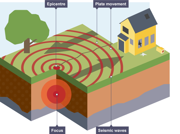
Seismic waves: resultant waves from earthquake
Body waves: transferred through Earth’s structure
Primary waves: incident compresses rock, causing a band of compression (high density) to move in the direction of the wave. Compression waves, where propagation is parallel to the direction of travel.
Secondary waves: incident compresses rock sideways, causing deformation in one direction and adjacent layers to move in the opposite direction. Transverse waves, where propagation is perpendicular to the direction of travel.
P-waves occur first, followed by S-waves at 60% of the speed. S-waves can only travel through solids due to the elastic properties of needed for a transverse wave. P-waves can cause liquefaction.
Surface waves: body waves arrive at surface, generating waves that propagate parallel to surface
Raleigh waves: similar motion to water waves – the ground ‘rolls’ but particles rotate away from the direction of travel
Love waves: faster than Raleigh waves, propagate across Earth’s surface, particles move side to side, perpendicular to the path of the wave’s energy
Surface waves do the most damage in an earthquake event, but are the result of body waves

Seismic scales
(Modified) Mercalli Scale: qualitative measurement of quake damage an area faces. It is possible to have low Richter magnitude, and high Mercalli result, if infrastructure and buildings are poorly constructed
Richter Scale: quantitative measurement of earthquake amplitude, measured with a seismometer. 0 10 scale, with 1 dp. Mapped to a logarithmic scale, so 1 integer increase = 10x quake strength = 32x energy release
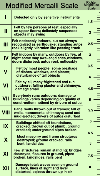
Frequency: how often earthquakes occur. Around 1 million Richter 2 earthquakes occur per year globally, but only 3 of Richter 8.
Factors affecting damage (to lives and property)
Strength, depth of focus and number of shocks
Population density and time of day
Building/soil/sediment types
Distance from epicentre
Economic development
Secondary hazards
Human interference
Disposal of liquid waste
Underground nuclear testing
Fracking/mining/explosions/tunnelling
Increased crustal loading
Earthquake Hazards
Primary Hazards: initial effects caused by an earthquake
Ground Shaking: the result of seismic waves passing through the ground that causes the collapse of infrastructure, structures, and buildings
Alaska, 27th March 1964: lasted 7 minutes
Loma Prieta, 17th October 1989: columns of Cypress viaduct collapsed – 41 killed when top layer fell on lower
Surface Faulting: displacement of the ground that will cause underground pipes and wires to fail
California, 1952: 3 railroad tunnels damaged, halting rail travel for 25 days despite 24 hour repair work
Secondary Hazards: occur because of primary hazards
Landslides/Avalanches: entire mass of material moves down a slope, holding its structure. Avalanche is snow
Seismic shocks cause sudden increase in shear stress
Must be a pre-existing slip plane or line of weakness
Huge seismic shocks breach line of weakness and triggers the mass movement
Or, ground motion causes mass on slip plane to fully detach and slide
Effects
Infrastructure destroyed: sewage/water pipes, telephone/electricity cables broken, isolating people
Blocked access: material on road networks blocks aid, food supplies and emergency (medical) access
Flooding: if mass falls into lake/reservoir, may suddenly displace water, or cause dam wall to fail
Management
Avalanches: snow compaction and land use plans
Land use planning or mapping
Pinning, netting, grading, afforestation, greening
Peru, 1970: ground-shaking from magnitude 7.9 quake loosened rocks and ice on Mt. Huascaran, triggering a 200km/h debris avalanche obliterating village of Yungay. 67,000 dead, 800,000 homeless
Soil Liquefaction: ground shaking causes weak/ unconsolidated material to act as a fluid, normally when ground water is high
Soil must be saturated/near a water body
Normally soil particles are tightly packed together held together by friction
Ground shaking destabilises soil and spaces between particles increases. Sudden pore water pressure increase causes soil to lose all cohesive strength
No cohesive strength in soil = loss of solid properties, behaves like a liquid
Effects
Gas and water pipe buckling: soil motion causes forces on pipes that they cannot withstand, therefore they fail – cuts off supplies to locals
Ground spreading: soil moves down like a liquid, surface features spread outwards
Sinking buildings: foundations suddenly unsupported, so buildings sink and tilt
Management
Improve foundations
Improve soil drainage (Vibro-compaction)
Do not construct on saturated or flood prone soil
Use of flexible pipes and automatic shut-off valves
Alaska, 1964: sandy layer of soft clay liquefied causing a landslide that destroyed 75 homes and utilities
Loma Prieta, 1989: extensive soil cracking
Tsunami: very long (200km wavelength) and high (up to 30m) series of waves caused by a large oceanic disturbance, other than tidal processes
Form as a result of sudden water displacement
Pressure builds up along an earthquake boundary with a ‘stick and slip’ relationship
Through tectonic processes, pressure and strain energy builds up between the plates
Plates eventually fail and slip, suddenly assuming new positions on the seabed – sudden displacement, eg. Flicking upwards
Almost all of released energy transferred to water
Water raised to above sea level, then swell falls under gravity, and splits into two opposite directions
Wave shoaling occurs near the shallower shore, as a huge amount of energy is compressed into less water volume. Wave speed (800km/h down to 50km/h) and wavelength reduces, height increases
Effects
Coastal retreat: as tsunami wave approaches, trough of wave following behind causes water to be pulled out to sea to form peak tsunami wave
Coastal flooding: few natural warnings – unprepared. Continuous wave doesn’t break until loss of energy around 10km inland, frequency of between 5-40 minutes on average
Management
Coastal abatement
Tsunami warning systems