ESCI 111 Week 5-6
What controls volcanic activity?
- Tectonic settings
- Eruption styles
- Types of magma
- “Type” of volcano
Where are Volcanoes on earth?
- Divergent margins = mid ocean ridges
- convergen t margins = subduction zones (oceanic arc)
- Intraplate = hot spots
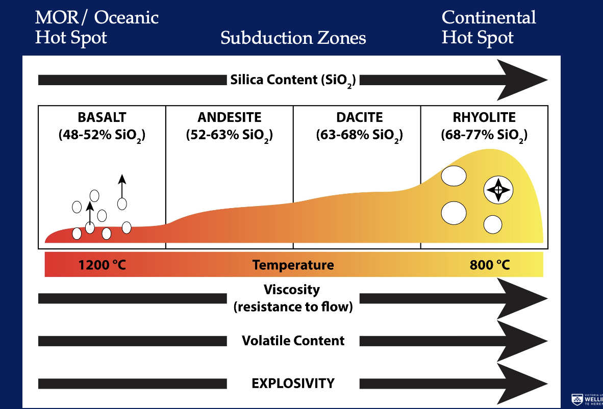
Types of magma
- Not all magma is made equal
Silica content is the mane chemical index for what magma we have
As we move up in silica we deal with a declining temperature - increase in viscosity (Resists flow)
Rhyolite brakes brottaly (Gas content)
Eruption styles
Form lava flows or domes
Magma viscosity (magma type) controls how fast/far the lava flows
- Mauna Loa (Hawaii) - Basalt
- Kelud (Indonesia) - Andesite
- Chaiten (Chile) - Rjyolite (generally more explosive)
Low gas content and low viscosity make for a mild explositivy of fluids
- Builds steep sided cones of loose pyroclastic fragments
Make for mild explositivy or fluid materials
Volcano can be a single cone or the cones can be small satellites on a larger volcanoes
Intesse explositivy: Rhyolite plinian deposit
Plumes can go buoyant into the stratosphere, to traverse the globe
Widespread deposits that evenly mantle the pre-existing topography
The tast eruption of Taupo was small compared to some in the geologic record, but still reached to well beyond Gisborne
Explosive eruptions
Proclastic flows:
- Explosive plumes sometimescannot ascend into the atmosphere
- They collapse to form a Proclastic flows
- They are ground hugging flows of hot particles and gasses
If water is added repid heat transfer from magma to water can chill a lava flow to rwstrict its movement
Steam eruptions are very hard to predict \
Water can increase the vigour of an otherwise mellow eruption
Plumes
- Magma is broken into particles by fragmentation
- Pyroclast = Broken Fire
- Degree of explosivity is controlled by volatile content, magma viscosity
Lower gas content - gas can escape
What controlls volcanic activity?
Fissure volcano:
A linear volcanic vent or series of vents
Most often associated with effusive basaltic eruptions but can be explosive
Mid oceanic ridge volcanism
Shield Volcano:
Broad low profile volcano built by a succession of basaltic lava flows
Eg. mauna Loa (Hawaii) the biggest volcano on earth
Mosly basaltic lava flowsbut can have cinder cones and occanisal explosive activity
(Rangitoto volcano)
Olympus Mons on Mars - biggest volcano in the solar system
Composite cones / straddle volcanoes:
Steep sided uilt up in successive layers of lava and pyroclastic material
Usually intermediate magma types - andesite and dacite
Common in continental volcanic areas
Classical volcano shape
(Ruapehu, Taranaki)
Combination of eruption styles
Caldera Volcanoes:
Highly explosive, large volumes
Subsidence structures formed from underlying chambers being empty
Crate big pyroclastic flows
(Lake Taupo)
Large igneous provinces:
Similar to hot pots but on an extreme scale
None in historical time
Deccan traps (india)
- 500,000 km2
- 2000m thick
- 66.25 million years ago, and lasted -30,000 years
Size of eruptions
- Hard to but a measure on it / classify them
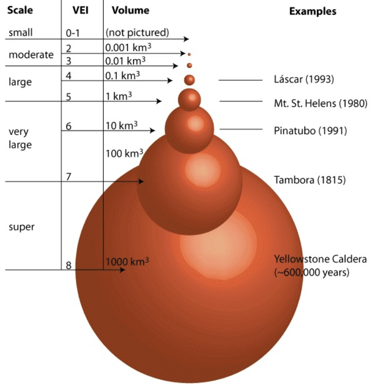
Hunga Tonga - Hunga Ha’apai
- Shock waves strong enough to shatter windows
- Shockwaves traveled round the earth at least 4 times
- Eruption was heard in NZ (2000 km away) some bangs heard in Alaska (9700 km)
- Mesosphere altitude of plume suggests that the main blast was more powerful that the most recent eruption of Taupo
Volcanology
Combination of fieldwork, chemistry, physics, material science, mathematics
Monitoring active volcanoes
geography/seismology
Seismology used to detect and read volcanic earthquakes
Activity detected by field instruments
Volcanic earthquakes have a different character to tectonic earthquakes, they show movement of magma in the subsurface
Mauna Loa permanently installed volcano monitoring networks
Seismology is used to detect and read volcanic earthquakes
Pinatubo eruption was predicted to the day by the use of an emergency network of seismometers
Deformation
Geodetic techniques are used to monitor volcanic deformation
- GPS
- Tilt meters
- Satellites
- Level lines
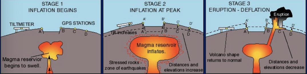
Think of volcanoes being static but they very much aren’t - magma chambers etc
Satellite techniques (INSAR) can detect deformation remotely
Deformation of Mt Etna, Sicily 2002
It still worked, just cant use it as reliable data
Volcanic gasses/fluids
The amount of chemistry of gas discharge from a volcano can tell a lot about its magma
Can be measured from afar with spectroscopic methods, or up close with direct sampling.\
UV spectroscopy can measure these gasses
Remote sensing
Many parameters can be measures from satellites, be remote sensing
Good for monitoring volcanoes when you can’t have a team on the ground
Can measure SO2 emissions
Direct observation
Field observations of active eruptions and their deposits
Some processes can only be determined by direct observation
Rhyolite eruption in progress - explosivity city and effucitvy happened at the same time
Drones
Look at things you otherwise could not see - get gear into places you can't reach
Geological mapping
When volcanoes are close to people or infrastructure, hazards become risks
Geological mapping allows eruption scenarios to be estimated and planned for
How people perceive risk
Stratigraphy / field geography
Distribution of deposits tells about the size and dynamics of eruptions
Small detail about the conditions during the eruption
Petrology and geochemistry
The minerals in lava and the microchemistry of the minerals tells a lot about the history of the magma
Textural analysis
The physical relationship between minerals, melt and bubbles tells us about the magma ascent
The bubbles represent evolved gasses (volatiles)
Numerical modeling
Theoretical and mathematical studies can be used to predict how volcanic eruption will proceed
Analogue modeling
Can make magma in the lab and sede what it does
Allows processes we can’t witness to be proven
Bad stuff can happen
Some volcanic hazards are directly associated with eruptions, others can be ongoing
Lava flows you can usually outrun a small lava flow, they can be very destructive (houses and property damage)
Large igneous province development can be linked to mass extinctions and transitions in the geological record
Pyroclastic flows
Ground hugging flows - destroy everything in their path
Tephra fall
Locally can pile up to cave in houses, burry victims
Mummified bodies
Can be widespread and disrupt air traffic
makes fine ash
Volcanic gas
During eruption can load atmosphere with aerosoles that affect global climate
Can be deadly even in absence of eruption
Lake Nyos, Cameroon 1986 C02 released from lake killed 1700 people overnight
Mitigated by pipes that go into the lake and release CO2
Lahars (big mud flow)
Volcanic mudflows can occur with eruption, or long after
Can range from tiny to enormous
Tsunami
Eruptions can generate a tsunami
Secondary hazard