Lecture 6: Introduction to Reference Systems, Reference Frames, and Geodetic Datums
Reference Systems
Complete conceptual definition of how a coordinate system is formed (theoretical definition)
Defines the origin and the orientation of fundamental planes or axes of the system
Includes the underlying fundamental mathematical and physical models
Conventional Reference System
reference systems where all models, numerical constants and algorithms are explicitly specified
Reference Frames
Practical realization of a reference system by observations and measurements
Consists of a set of identifiable fiducial (taken as standard of reference) points on the sky (e.g. stars, quasars) or on the Earth’s surface (e.g. fundamental stations)
Reference Systems and Reference Frames
A reference frame is the skeleton/structure for which positions of points are being referred.
A reference system is the scheme to which position of points are being determined based on reference frame.
In practical surveying, we interact with reference frames, but the underlying concepts of a specific reference system, frame and datum are of fundamental importance.
*Two Fundamental Systems
Conventional Inertial Reference System (CIS)
Spaced-fixed
Also called as Celestial Reference System
Usually related to extraterrestrial objects like stars, quasars (extragalactic radio sources), planets or moons
Based on kinematic or dynamic considerations:
Kinematic CRS - a theoretical, non-rotating coordinate system used to define the positions of celestial objects based on their directions of arrival in the absence of solar system mass
Dynamic CRS - rely on physical laws, purely geometrical concept. Defined by the gravitational influence of objects within a system, such as planets or stars
Conventional Terrestrial Reference System (CTS)
Earth-fixed
Can be realized through a set of Cartesian coordinates of fundamental stations or markers within a global network
Ideal Conventional Terrestrial Reference System
Origin should be fixed to the geo-center, including the mass of the oceans and the atmosphere
Z-axis should coincide with rotational axis of the Earth
Geodetic and Celestial Reference Systems and Frames
Geodetic/Terrestrial
Geodetic/Terrestrial Reference System (GRS/TRS)
Conceptual idea of an earth-fixed Cartesian system (X,Y,Z)
Geodetic/Terrestrial Reference Frame
Practical realization of a geodetic reference system by observation of terrestrial points
Celestial
Celestial Reference System (CRS)
Conceptual idea of a spaced-fixed Spherical coordinate system
Celestial Reference Frame
Practical realization of a celestial reference system by observations of stars or other celestial bodies
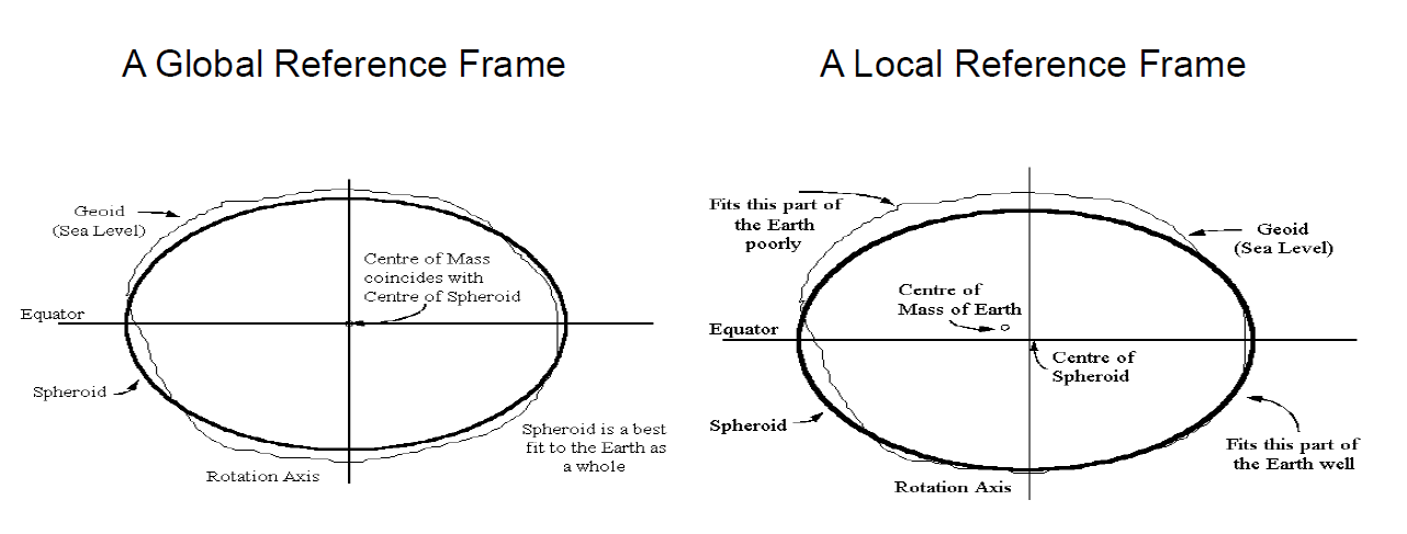
Global and Local Geodetic Reference System
Global GRS
Origin: Earth’s center of mass
Z-axis: Coincides with the mean rotational axis of Earth
X-axis: Mean meridian plane of Greenwich and ± to Z-axis
Y-axis: Orthogonal
Local GRS
Origin and orientation of axis is arbitrary
Global and Local Geodetic Reference Frame
Global Reference Frame
Looking at the definition of a reference frame, there should only be one global reference frame
Local Reference Frame
Since each country/area in the surface of the Earth uses a frame that is appropriate to the local surface, there are infinite number of local frames.
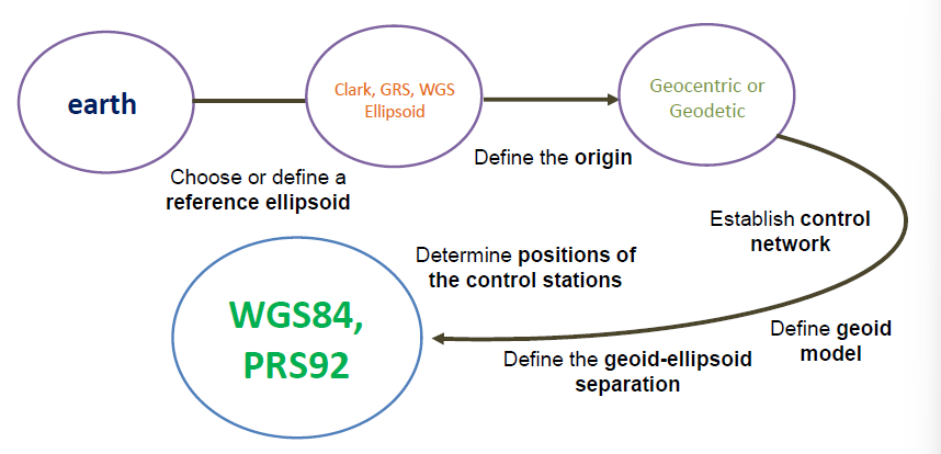
Geodetic Datum
The term “datum” is often used when one actually means “reference frame”.
A geodetic datum is expressed in terms of the set of transformation parameters which are required to define the location and orientation of the local frame with respect to the global one.
Minimum set of parameters required to define location and orientation of the local system with respect to the global reference system/frame.
Used as reference for computing the positions of a point observed in the surface of the Earth for geodetic and mapping purposes at a certain portion on the surface of the Earth.
Geodetic Datum vs Reference Frames
A geodetic datum is the specific mathematical and physical model used to define a coordinate system, while a reference frame is the physical realization of that model through ground monuments or satellite observations.
Types of Datum Based on its Function
Horizontal Datum
a base reference for a coordinate system. It includes the latitude, longitude, and orientation of an initial point of origin of an ellipsoid that models the surface of the earth in the region of interest.
Vertical Datum
is a surface where elevation of a point is referred
Complete Datum
integration of the horizontal datum and vertical datum. A geodetic datum is a complete datum.
Types of Geodetic Datum Based on the Location and Orientation of its Origin
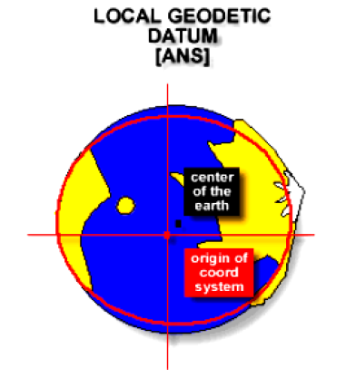
Regional / Local Geodetic Datum
The type of datum in which the reference ellipsoid fits the surface of the Earth on a certain region or locality.
The center of the ellipsoid does not necessarily coincide with the center of mass of the Earth.
The origin of the coordinate system is the tangent point of the reference ellipsoid and the geoid.
Global Earth-Centered (Geocentric) Geodetic Datum
The origin of the coordinate system coincide with the center of mass of the Earth
The reference ellipsoid fits the shape of the surface of the Earth globally.

Limitations of a Regional / Local Geodetic Datum
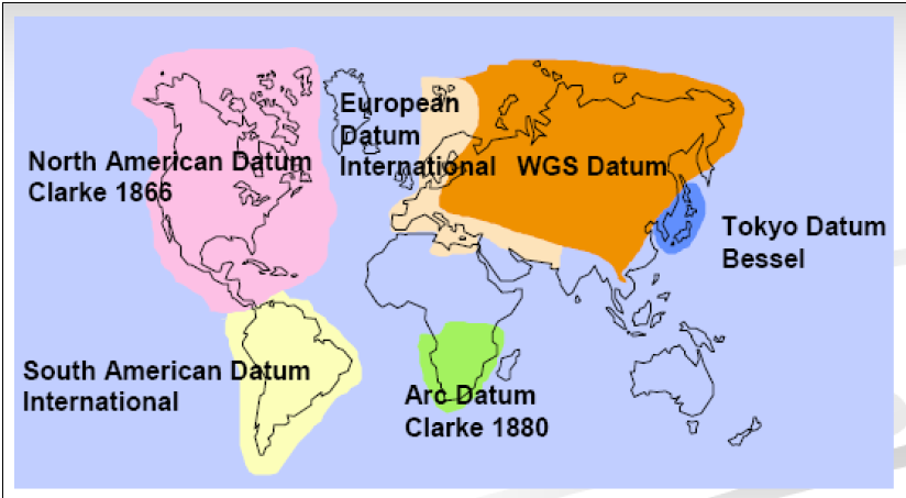
Many nations established their own datum
Standards and procedures of establishment vary widely
Coordinates from different datum are completely incompatible (they are relative to the initial point of the datum and the parameters of the reference ellipsoid)
The only geodetic method of establishing a reference system based on a global geodetic datum, at the moment, is through the use of satellite-based positioning system.
Regions that does not have a compatibility of satellite-based positioning will have a problem adopting this kind of datum.
Most Widely Used Regional / Local Datum
The Tokyo Datum
The 3rd of the initially selected datums has its origin in Tokyo. It is defined in terms of the Bessel Ellipsoid and oriented by means of a single astronomic station. With triangulation ties through Korea, the Tokyo Datum is connected with the Manchurian Datum.
The South American Datum
In 1965, the Working Group for the Study of the South American Datum was asked by the Committee for Geodesy of the Cartographic Commission of the Pan American Institute of Geography and History (PAIGH).
The Indian Datum
The Indian Datum has been used for India and several adjacent countries in Southeast Asia. It is computed on the Everest Ellipsoid with its origin at Kalianpur in Central India.
Geodetic Datum and Geodetic Reference Systems
Continuously Operating Reference Stations (CORS)
A permanent Global Navigation Satellite System (GNSS) receiver, antenna (with a surveyed reference position), and support equipment
The CORS network is a multi-purpose cooperative endeavor involving government, academic, and private organizations
CORS Hardware
GNSS Receiver
Uninterruptible Power Supply (UPS)
Receiver location
Surge protection
Internet connection
GNSS Antenna
antenna type
type of leveling device
antenna location
monumentation / mounting
lighting protection
grounding
antenna cable
length / type
routing
Site Selection
Clear view of the sky - unobstructed view of the horizon 360°
No nearby signal reflectors - 0.5m to 1.5m above horizontal surfaces
No nearby signal transmitters - 300 meters
Stability
thermal expansion
wind loading
soil expansion / contraction