India: Location and Physical Features Notes
India: Location and Physical Features
India's Diversity and Geographical Identity
India is known for its diversity, including:
Lofty mountains
Rugged plateaus
Vast plains
Mighty rivers
Varied physical features
Stark climatic contrasts
Huge variety of vegetation types
Despite diversities, India has a distinct geographical identity.
India and some neighbouring countries are referred to as the Indian subcontinent.
Size and Location
Area: million sq km, the seventh-largest country in the world.
Second most populated country after China.
Lies entirely in the Northern and Eastern Hemispheres.
Latitude: to
Longitude: to
The Tropic of Cancer passes almost through the middle of India.
Longitude of is the Standard Meridian of India; its local time is the Indian Standard Time.
Southern part of India is a large peninsula, bound by:
Arabian Sea in the west
Bay of Bengal in the east
Indian Ocean in the south
In the north, lofty mountain ranges separate it from the rest of Asia.
Located in the south-central part of the continent of Asia.
Situated at the head of the Indian Ocean (the only ocean named after a country).
Strategic position helps in trade with eastern and western countries.
Indian mainland has a km long coastline.
Land frontier is km long.
Two island groups that belong to India:
Andaman and Nicobar
Lakshadweep
India's Neighbouring Countries
Neighbouring countries share boundaries with India.
Pakistan lies to the northwest.
Afghanistan, China, and Nepal make up the northern borders.
Bhutan is to the northeast.
Bangladesh and Myanmar are eastern neighbours.
Island countries of Sri Lanka and Maldives lie to the south and southwest, respectively.
Sri Lanka is separated from India by the Palk Strait.
Political Divisions
India is divided into 28 states and 8 union territories.
Division is mainly based on languages spoken in different areas.
Delhi is known as the National Capital Region.
Rajasthan is the largest state.
Goa is the smallest state.
Among the union territories, Andaman and Nicobar Islands are the largest and Lakshadweep islands are the smallest.
Physical Divisions
India has 6 broad physical divisions:
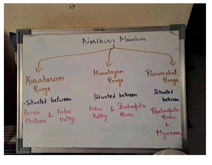
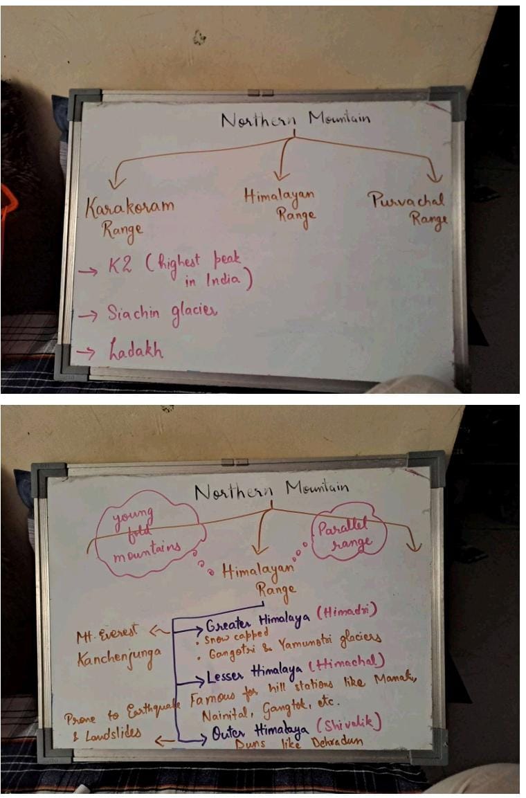
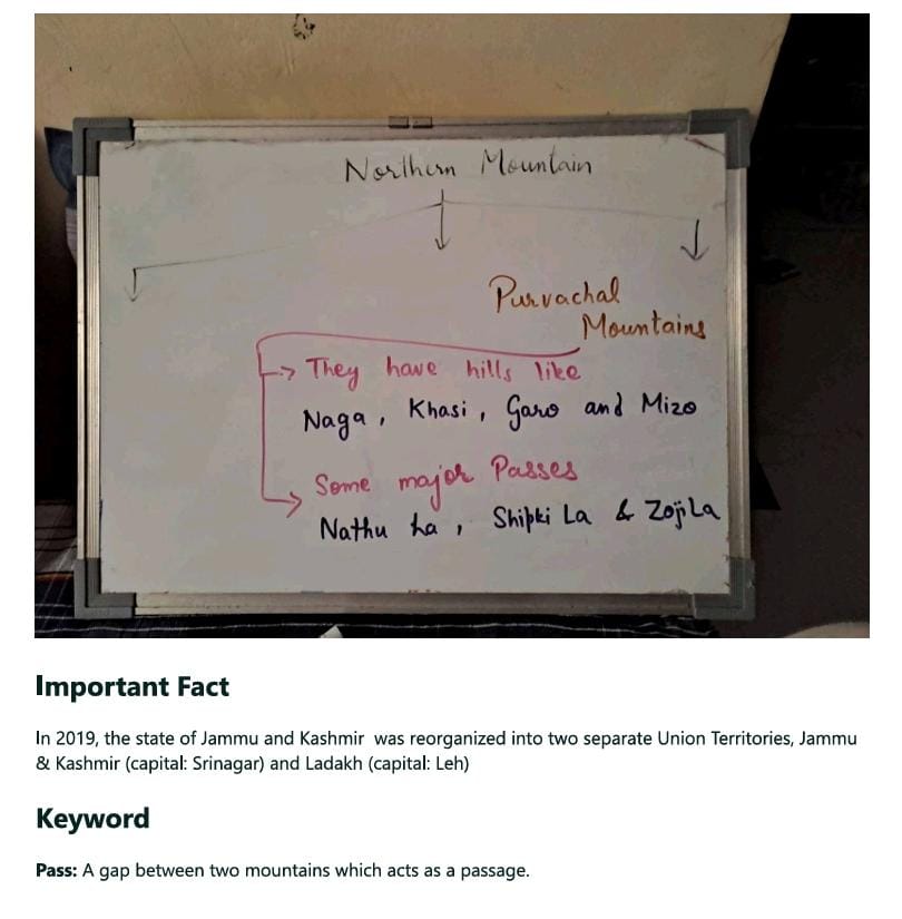
Northern Mountains
Northern Plains
Peninsular Plateau
Great Indian Desert
Coastal Plains
Islands
The Northern Mountains
The Northern Plains
To the south of the Northern Mountains lies an extensive flat plain, known as the Indo-Gangetic Plain.
Made up of alluvium deposited by the rivers Indus, Ganga, Brahmaputra and their tributaries.
Alluvial deposits make the plains extremely fertile and suitable for agriculture.
Stretch for about km, from Punjab in the west to Assam in the east.
Divided into three sections from west to east:
The Indus Plain
The Ganga Plain
The Brahmaputra Plain
Indus Plain
Drained by the River Indus and its tributaries (Chenab, Jhelum, Ravi, Beas, and Satluj).
The major part of this plain lies in Pakistan.
The Indian portion is located in Punjab and Haryana.
Ganga Plain
The most extensive part of the Northern Plains.
Covers Uttar Pradesh, northern Madhya Pradesh, Bihar, and West Bengal.
Drained by River Ganga and its tributaries.
Yamuna is the chief tributary of Ganga.
Other important tributaries are Ghaghra, Gandak, Kosi, Son, and Damodar.
Brahmaputra Plain
Located in Assam.
Drained by River Brahmaputra and its tributaries (Subansiri, Bharali, Manas, Dhansiri, and Tista).
The Brahmaputra rises in Tibet, where it is called the Tsangpo.
It enters India in Arunachal Pradesh and after flowing through Assam, it enters Bangladesh where it is joined by the Ganga.
These two rivers together form the largest delta in the world, the Ganga-Brahmaputra Delta, also known as the Sundarban Delta.
A major part of it lies in Bangladesh.
The Peninsular Plateau
To the south of the Northern Plains lies the oldest landmass of India.
Covers most parts of central and southern India.
Made of hard igneous and metamorphic rocks.
Has two distinct parts:
The Malwa Plateau in the north
The Deccan Plateau in the south
The Narmada river valley lies in between these two plateaus.
Malwa Plateau.
All the rivers which rise in this plateau—Chambal, Betwa, Ken, Son and Damodar—join either the Ganga or Yamuna.
Deccan Plateau
South of the Narmada Valley and triangle-shaped.
Extends up to the tip of the peninsula in the south.
This region is made up of sheets of lava that oozed out from huge cracks on the Earth's surface millions of years ago.
The Peninsular Plateau is drained by a number of large rivers.
Mahanadi, Godavari, Krishna and Kaveri form large deltas before flowing into the Bay of Bengal
Narmada and Tapi are the only rivers in this region which flow into the Arabian Sea.
These rivers are rain-fed and seasonal, unlike the Himalayan rivers and not suitable for navigation.
Comparison of Eastern and Western Ghats
Western Ghats | Eastern Ghats |
|---|---|
The hills are continuous. | The hills are discontinuous, broken by deltas of the Deccan rivers. |
They are high. | They are low. |
Swift rivers such as Narmada and Tapi flow through them. | Long broad rivers such as Mahanadi, Godavari, Krishna and Kaveri drain the region. |
The Great Indian Desert
To the northwest of the Aravalli Hills lies the Great Indian Desert or the Thar Desert.
Most of the rivers or streams of this vast sandy desert either drain into salt water lakes or disappear into the sand.
Such an area, where the rivers do not reach the sea, is called an area of inland drainage.
Luni is the only large river in this region.
Lake Sambhar is an important salt water lake here.
Comparison between Himalayan and Peninsular Rivers
Himalayan Rivers | Peninsular Rivers |
|---|---|
They are perennial. | They are non-perennial. |
They rise in the Himalayan glaciers and are snow-fed. | They rise in the plateau region and are rain-fed. |
They are suitable for navigation. | They are not suitable for navigation but are useful to generate hydroelectricity. |
The Coastal Plains
Bordering the Western and the Eastern Ghats are narrow coastal plains known as the Western and Eastern Coastal Plains, respectively.
The Western Coastal Plain is known as the Konkan Coast in the north and Malabar Coast in the south.
The Eastern Coastal Plain is known as the Northern Circars in the north and the Coromandel Coast in the south.
Comparison between the Western and the Eastern Coastal Plains
Western Coastal Plain | Eastern Coastal Plain |
|---|---|
It is a narrow strip, bordered by the Western Ghats and the Arabian Sea. | It is a wide plain, bordered by the Eastern Ghats and the Bay of Bengal. |
It merges with the Gujarat Plain. | It merges with the Ganga-Brahmaputra Delta. |
There are estuaries and lagoons or backwaters, particularly in Kerala. | It includes the large deltas of Mahanadi, Godavari, Krishna and Kaveri. |
The Islands
There are two island groups which belong to India: the Lakshadweep and the Andaman and Nicobar Islands.
Lakshadweep Islands
Lying in the Arabian Sea, they are a group of coral islands.
They are small in size and few in number.
Formed due to the accumulation of coral polyps.
Andaman and Nicobar Islands
Lie in the Bay of Bengal.
Are bigger in size and more numerous.
Actually the peaks of submerged volcanic mountains.
Barren Island, the only active volcano in India, is located here.
Many of these islands are uninhabited.
Some are inhabited by tribal people who remain cut off from the outside world.
Geographical Unity of the Country
Despite India's great diversity of physical features, they give the country a distinct geographical identity.
All the major physical divisions are complementary to each other and are interdependent in their formation.
Each is important in its own way:
The high Himalayan ranges have acted as natural barriers against foreign invaders and protect the country from the cold winter winds of the north.
They also cause rainfall and are the source of perennial rivers.
The fertile Indo-Gangetic plain is suited for agriculture and is called the 'food bowl of India'.
The Peninsular Plateau is a storehouse of minerals.
The Coastal Plains are dotted with ports and harbours, which help in trade.
Each region depends on the others for its development, and all contribute to the economy of the country.
Therefore, we should utilise the resources of each region in a balanced manner for overall development of the country.
Key Terms
Estuary: The mouth of a river, where it enters the sea through a single channel.
Lagoon: A shallow body of water separated from the sea by a sandbank, forming a saltwater lake.