River Environments
RIVER ENVIRONMENTS
THE HYDROLOGICAL CYCLE
Definitions:
Hydrosphere | All the water stored on the Earth’s surface and in the atmosphere |
Hydrological cycle | The sum total of all processes in which water moves from the land and ocean surface to the atmosphere and back in the form precipitation |
Evaporation | When liquid water is converted to water vapour due to heat |
Condensation | When water vapour cools and turns back into liquid water |
Precipitation | When water stored in clouds fall to earth as rain, snow, hail or sleet |
Transpiration | When water is evaporated from leaves of plants and trees |
Surface Water | Water stored on Earth’s surfaces eg. in lakes or ponds |
Surface Runoff | Water flowing along the along the Earth’s surface eg. water in rivers |
Groundwater | Water stored in the ground eg. aquifers (rocks that store water) |
Groundwater Flow | Water flowing through the ground eg. underground rivers |
Infiltration | When water soaks into the ground |
Percolation | Water flowing downwards through soil and rock |
Transfer | Processes where water is being moved from one store to another |
Store | When water is being contained in one place |
Stores of Water:
97% of water is stored in oceans and seas (however it is saline) and these bodies of water make up 70% of the earth.
The rest of the world’s water (3%) is freshwater and stored in the following places:
0.1% held in rivers, lakes and resevoirs – the largest volume of freshwater on Earth is Russia and is 31500 sq km with a maximum depth of 1637m
0.6% held as groundwater (however 30% of water on earth is held as groundwater)
0.001% is held as water vapour and clouds
2% held as ice & snow.
Hydrological Cycle:
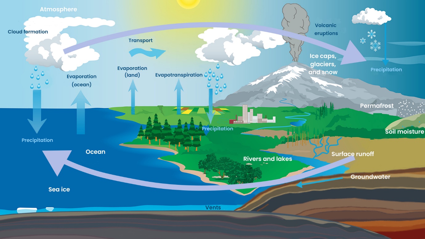
Inputs | Flows | Outputs | Stores |
|
|
|
|
HYDROGRAPHS
Factors Influencing River Regime:
Factors | How they influence the river regime |
Climate | Climate is the most important factor. Precipitation - the amount of rainfall, rainfall intensity and duration are important factors. Colder regions may experience more snow which can be stored as ice which then melts into the rivers during warmer periods eg. The River Ganges is heavily impacted by now melt from the Himalayas. Temperature can also contribute by increasing evaporation rates or allowing for larger amounts of water vapour in the atmosphere, leading to high precipitation. |
Vegetation | Areas of high vegetation cover intercept more rainfall, allowing water to reach the ground more gradually compared with poorly vegetated areas. This reduces overland flow and increases infiltration rates into the soil. Deforestation can have a huge impact on the river regime, seasonal changes to vegetation (eg. Deciduous trees) means discharge can experience more change during different seasons. |
Geology | The permeability and porosity of rocks and soils are major influences on drainage basins. Porous and permeable rocks allow the accumulation of groundwater, which is gradually released into the rivers as base flow. Porosity - measure of a rock's ability to hold water. Higher porosity means that water can move through the pores of a rock. Permeability - measure of the ease with which water can flow through the rock. The pores much be connected for rocks to be permeable. |
Soil | The more compact the soil, the less infiltration and therefore greater overland flow:
|
Land Use | Runoff is much faster in urban areas due to impermeable surfaces of concrete. They are much less forested and green spaces often have heavily compacted soils due to high usage. Drainage systems are designed to remove surface water as quickly as possible and are often directed into rivers. |
Water Abstraction and Dams | Removal of groundwater from the surface or underground. Water is abstracted for human purposes such as consumption and irrigation. Abstraction changes surface water flows and indirectly lowers groundwater levels. Dams regulate river flow for purpose of flood control, navigation, irrigation, hydropower and water supply. Reservoirs behind dams experience significant evaporation. |
Other Factors | Size and shape of basin - small basins response most quickly to rainfall events Slopes - steeper slopes = more overland flow Drainage density - basins with high drainage density respond very quickly to storms |
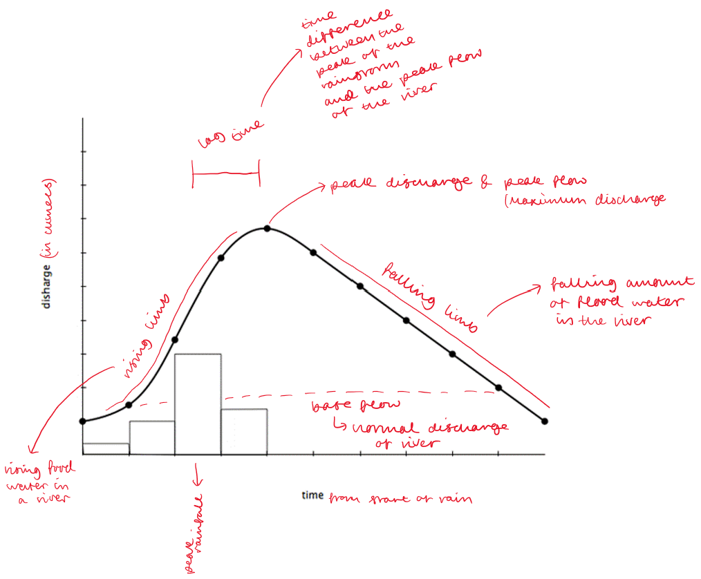
Hydrographs:
PROCESSES INFLUENCING RIVER ENVIRONMENTS
Weathering:
Weathering is the breakdown of rocks in situ (without moving). In a river it occurs where you have joints (vertical cracks in rocks) and bedding planes (horizontal cracks). Weathering can be physical, biological or chemical.
Physical Weathering
Water enters cracks in the rocks. When temperatures fall at night, the water freezes. When water turns to ice it expands by 10%. This therefore puts pressure on the rock and forces the crack to get bigger. In the morning, the ice melts, water then seeps deeper into the crack before freezing again. This process repeats every night and large blocks of rock can be shattered by repeated freeze-thaw weathering over a long period of time.
Biological Weathering
Weathering that is caused by organisms such as plants, animals, fungi and microorganisms. Biological weathering is prominent in drainage basins, particularly due to root systems of plants and tree gradually break apart rocks.
Examples:
Plants & Trees – roots get into cracks in rock and weaken them – this makes them bigger
Animals might trample on the ground or dig up vegetation
Animals might burrow into the ground, breaking down the soil structure
Fungi can penetrate minerals, forming tunnels and channels
Plant roots can produce organic acids which helped to dissolve minerals
Microbial activity breaks down minerals by altering rock’s chemical composition, making it more susceptible to other types of weathering
Chemical Weathering
Chemical weathering refers to the weather of rocks by rainwater which is slightly acidic. It is most effective below the surface as percolating water has gained organic acid from the soil and vegetation it has passed through. It is most prominent with rocks like limestone and granite.
Mass Movement:
Slumping: occurs when a significant section of rock moves a short distance down a slope in a rotational movement. This often occurs when softer materials overlie more resistant impermeable materials. The softer material becomes saturated with rainwater and as a result slides downwards.
Soil Creep: a slow, small-scale movement of individual soil particles downslope under the influence of gravity. It moves at a rate of 1-3mm per year in temperate areas and up to 10mm per year in tropical areas. Frequently occurs on slopes with an angle of more than 5 degrees.
Erosion:
Erosion is the breakdown of materials through movement (sediment is moved by the water in the river and broken down).
There are 4 main types of erosion:
Hydraulic action
Abrasion
Attrition
Solution
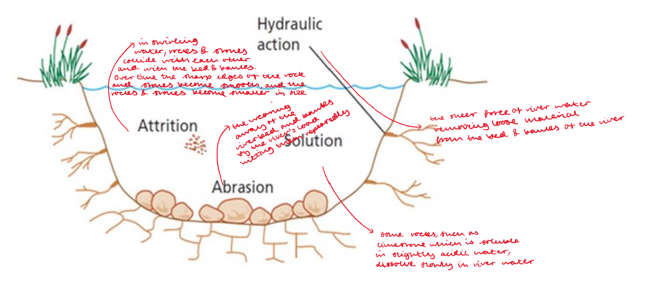
Lateral Erosion (sideways): takes place in the middle & lower course and widens the valley
Vertical Erosion (downward): upper course near source cuts down into its bed deepening valley
Types of Transport:
Traction: Stones rolled along the riverbed (needs the most energy)
Saltation: Sand-sized particles ‘bounce’ along the riverbed
Suspension: Small slit and clay sized particles are held within the water and carried by the river’s flow
Solution: Some minerals dissolve in the water (needs the least energy)
Deposition:
Deposition refers to when material in a river fall out of transportation because of a lack of energy to carry the material. This happens when:
Gradient decreases
Discharge falls during dry periods
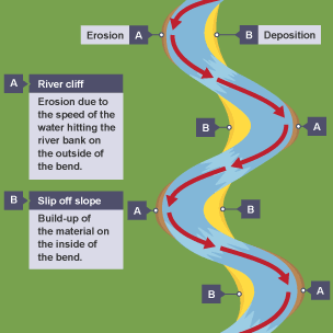
Current slows on the inside of a meander
River enters a lake or sea
CHANGING RIVER ENVIRONMENTS ALONG ITS COURSE
Discharge: the amount of water passing a specific point at a given time
Velocity: speed at which the river is flowing (m/s)
Load: material carried by river eg. stones & sediment
Bradshaw Model:
The Bradshaw Model is a theoretical model that helps describe the changes we expect to see as we travel from a rivers source to its mouth. It highlights changes in discharge and velocity, width and depth of a river channel, material within the river, as well as changes to the surrounding landscape.
The River Tees:
| Upper Course | Middle Course | Lower Course |
Channel width | Very narrow stream,
| Wider course, | Widest course |
Channel depth | Shallow
| Deeper | Deepest |
Describe the landscape | 'V' shape valley, interlocking spurs, steep sides
| Flat | Flat |
Sediment | Chunky rocks and stones: very large and angular
| Smaller rocks and stones | Can only carry and deposit fine sediments, smooth channel |
Velocity | Low velocity
| faster velocity | Slowest velocity - slow flowing |
Main processes | High vertical erosion
| Erosion, bedload transport | n/a |
Landforms | 'V'- shape valleys, interlocking spurs Waterfalls
| Waterfalls (between upper & middle course), meanders (constantly changing) | Meanders (some have been changed however) |
Settlements and uses by people
| Little use - small agriculture farms for pasture & cattle | Agriculture - 95% farmland | Industries needing water & access to the seas. Nuclear power stations, steel works etc |
General River Course Characteristics:
UPPER COURSE | Land Forms | Characteristics |
|
|
|
MIDDLE COURSE | Land Forms | Characteristics |
|
|
|
LOWER COURSE | Land Forms | Characteristics |
|
|
|
UPPER COURSE
V-Shaped Valleys:
The upper course contains many V-shaped valleys. Rivers in upland areas contain large boulders that can erode the riverbed rapidly when the river is flooded. This means that the river cuts downwards into its bed vis vertical erosion to form steep V-shaped valleys.
They V-shape valleys form because soil and loose rocks on valley sides wash down the steep slopes and add to the river’s load.
Interlocking Spurs:
Interlocking spurs are formed when resistant rock cannot be eroded so therefore the river goes around it before reaching another resistant rock and going around that. This forms interlocking spurs.
In the upper course, the river does not have a huge amount of energy to erode as it does not have a high discharge and it has to transport large piece of sediment. When the river meets areas of harder rock that are difficult to erode, it winds around them. A series of jills on either side of the river called spurs. As the river flows are these hills they become interlocked. SO a series of interlocking spurs are often found in the upper course of a river valley.
Rapids: When alternating types of hard and soft rock cross the course of a river, it creates an even riverbed. It also creates zones of turbulent water known as rapids. Rapids can also form where a layer of hard rock dips gently downstream.
Potholes: When the river bed is uneven, pebbles can temporarily become trapped by a larger obstacles. The current of the river causes the pebbles to move in a circular motion & therefore erode (via abrasion) into circular depressions known as potholes.
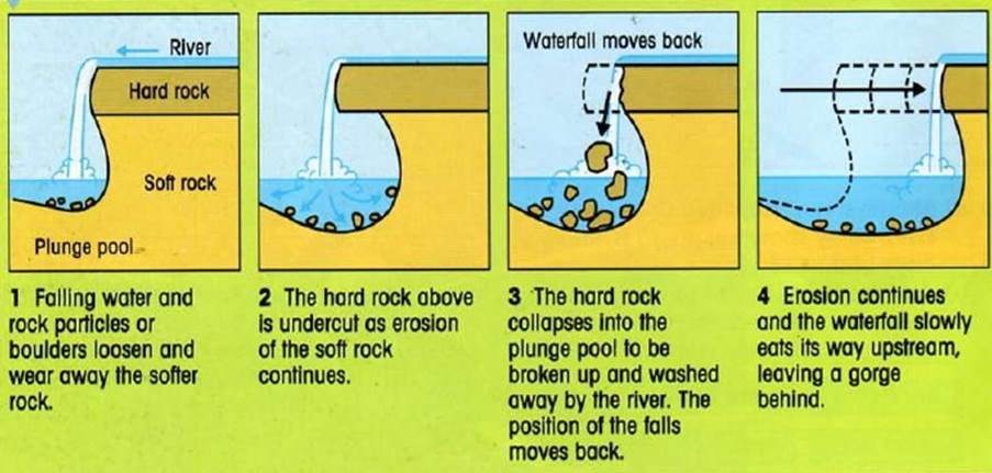 Formation of Waterfalls and Gorges:
MIDDLE COURSE
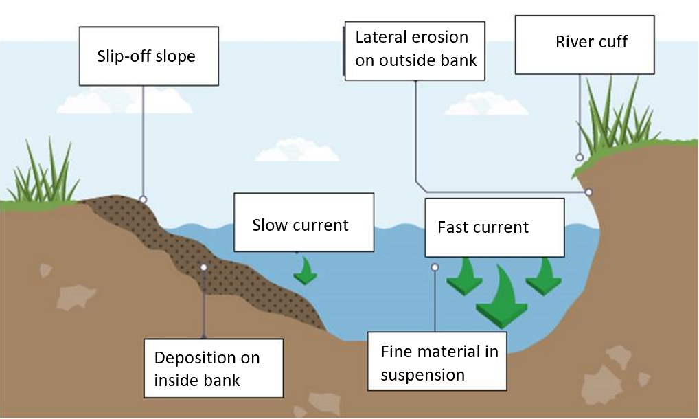 In the middle course, the river has more energy and a high volume of water. The gradient here is gentle and lateral erosion has widened the river channel. The river channel has also deepened. The bedload is smaller. At larger river channels there is less friction so the water flows faster.
Meanders:
Oxbow Lakes:
LOWER COURSE
Floodplains:
A floodplain is a wide area of flat land on both sides of a river. A floodplain is a depositional feature. They form due to both erosion and deposition. Lateral erosion widens the valley and removes any interlocking spurs, creating a wide, flat area on either side of the river. The floodplain is often caused by meanders shifting along the valley. At times of exceptionally high discharge, a river may burst its banks. Due to increased friction, the material normally carried in suspension is deposited as alluvium (deposits of clay, slit and sand from a river flood).
Levees:
A levee is an embankment (natural or manmade) made up by deposited material during a river flood. Levees occur in the lower course of a river when there is an increase in the volume of water flowing downstream and flooding occurs. When the river floods, the sediment spreads out across the floodplain. When a flood occurs, the river loses energy. The largest material is deposited first on the sides of the river banks and smaller material further away. After many floods, the sediment builds up to increase the height of the riverbanks, 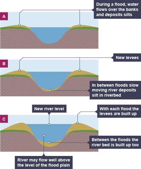 meaning that the channel can carry more water (a greater discharge) & flooding is less likely to occur in the future.
River Mouths and Estuaries:
A river mouth is where a river flows into a larger body of water such as another river of a lake/reservoir, a bay, a sea or an ocean. At the river mouth, sediments are often deposited due to the slowing of the current, reducing the carrying capacity of the water.
An estuary is where the river meets the sea. The river here is tidal and when the sea retreats, the volume of water in the estuary is reduced. When there is less water, the river deposits silt to form mudflats which are an important habitat for wildlife.
Deltas:
Deltas are landforms formed at the mouth of a river, where the river meets a body of water with a lower velocity than the river (eg. a lake or sea), resulting in the reduction in the river’s capacity to transport sediment. Deltas are found at the mouth of large rivers eg. the Mississippi. A delta is formed when the river deposits its material faster than the sea can remove it. When a river meets the sea in a sheltered and shallow area, the material it carries is deposited rather than carried away out to sea.
Three types of deltas:
Arcuate of Fan-Shaped: the land around the river mouth arches out into the sea and the river splits many times on the way to the sea, creating a fan effect.
Cuspate: the land around the mouth of the river juts out arrow-like into the sea.
Bird’s Foot: the river splits on the way to the sea, each part of the river juts out – rather like a bird’s foot.
USES OF WATER
The world’s water cycle is a closed system involving water sources such as rivers and lakes.
Reservoirs: artificial lakes created by building a dam across a valley and allowing it to flood.
Aquifers & Wells: much of the world’s fresh water supply lies underground. It is stored in porous rocks known as aquifers. This groundwater can be extracted by drilling wells or boreholes down to the aquifers.
Uses of Water:
Global water use increased from 1.22 trillion cubic metres in 1950 to more than 4 trillion cubic metres today. Irrigated farming accounts for almost 70% of annual global water consumption, which rises to 90% in some countries such as India.
Agriculture – 69% mainly irrigation and crops
Industry – 19% for transport and industrial processes (eg. textile and paper manufacture)
Domestic – 12% for drinking, food preparation, personal hygiene, washing
Demand and Supply:
Demand: this is the need for water for a range of uses; it is also often referred to as consumption, and the amount of water consumed reflects the level of demand.
Supply: meeting the demand for water by tapping various sources, such as groundwater, lakes and rivers.
For any country or area within it, we can compare water demand and water supply. This comparison is known as the water balance.
Reasons for Increase in Demand and Consumption:
Rising living standards - more items used which consume water eg. Washing machines. Changing patterns of food consumption - grain-based to protein-based diet. Increasing urbanisation - 30% in 1950 to around 58% in today. Wealth is generated faster in urban areas. High water demand for industry and recreation - estimated that demand for water in manufacturing will increase by 400% between 2000 and 2050.Population growth - 2.5 billion in 1950 to 8 billion in 2023.
Water deficit – areas where the water balance is negative - where water demand exceeds supply.
Water surplus – areas where the water balance is positive - where the supply or availability of water exceeds demand.
Water neutral – areas where water demand and supply are roughly the same, where the water balance is equal.
Global Water Crisis:
For about 40% of the world's population, lack of water is a constant threat. With demand doubling every 20 years, this situation is getting worse. Lack of supply and mismanagement of sources are at the source of these issues.
A 2021 World Bank report noted that:
2.2 billion people do not have safely manged drinking water services.
4.2 billion do not have safely managed sanitation services.
Water Shortages and Surplus:
Economic Scarcity – Caused by economic reasons (unable to extract water).
Potable Water – Water that is free from impurities, pollution and bacteria and it is thus safe to drink.
Water Scarcity – A deficiency or lack of water supply. This is further defined as when water supply falls below 1000 cubic metres per person per year.
Water Supply – The provision of water by public utilities, commercial organisations or by community endeavours.
Water Stress – When water supply is below 1700 cubic metres per person per year.
Physical Scarcity – Caused by physical reasons (drought, location etc.)
Uneven distribution of water means that there is a variation in the amount of water different regions have access too:
More than 60% of the world's population live in areas that receive only 25% of global annual precipitation
Arid regions cover 40% of the world's land areas but receive only 2% of global precipitation
Case Study:
Water surplus: Brazil (Amazon Rainforest)
Water deficit: Morocco
Water neutral: UK
Brazil (Amazon Rainforest)
There is a big water surplus in Brazil because they have the Amazon Rainforest. This has quite a humid climate so it rains a lot and therefore is a quite a big water surplus. However due to deforestation many trees are being cut down reducing the size of the rainforest and therefore some of the rainfall.
Morocco
In Morocco there is very little rainfall. Therefore, there are a lot of droughts. This means that to get water, people have to dig very far underground to freshwater sources. However because so many people dig to reach freshwater there is not very much left. This causes a huge water deficit throughout the country. However the government plan to place desalination plants on the coast to get more water and increase the fresh water throughout Morocco.
United Kingdom
The UK is water neutral. This means that the amount of water is enough to meet demand. The UK gets most of its water from surface water (so natural rivers and lakes). They have a few desalination plants however they mainly use surface water to get water. The UK also has lots of reservoirs located throughout the country, for example around Heathrow, which are also a water source.
WATER SUPPLY & QUALITY
Human Activity Impact on Water Quality:
The composition of surface and groundwater has an impact on water quality & depends on two factors:
Natural conditions in the drainage basin
Human intervention
Pollution:
The World Bank classifies pollution as:
Pollutants of Poverty – when LIC governments cannot provide finance/ water treatment.
Pollutants of Growing Property – eg. Use of nitrogen as fertiliser has risen by more than 700% since 1960s.
Emerging Pollutants – microplastics & other pollutants associated with HICs.
Key Sources of Pollution
Agricultural runoff (particularly from factory farming).
Industrial pollution.
Urban runoff carrying pollutions from cars, factories & other sources.
Untreated sewage (this has increased with growing populations).
Impacts of Not Having Access to Safe, Clean Drinking Water:
Nearly 1 million people die each year from water, sanitation & hygiene related diseases.
Water borne diseases such as cholera, diarrhoea, dysentery, typhoid & polio.
Physical wellbeing – women & children have to carry heavy vessels of water long distances daily.
Impacts of development – because they need to collect water daily, women & children cannot go to school or work.
Lack of access to clean reliable water can lead to conflict between different groups.
Storage & Supply of Clean Water
Rivers & Lakes – possible source used by earliest humans.
Dams & Reservoirs – artificial lakes created by building a dam across a valley & allowing it to flood. Water is collected & stored behind dams. Dams can become important to water supply.
Aquifers & Wells – much of the world’s freshwater supply lies underground, stored in porous rocks called aquifers. Water can be extracted by drilling wells or boreholes which allow for water to be raised to the surface by buckets, pumps or under its own pressure.
Method | How do they help supply clean water? | Issues / limitations? |
Dams and reservoirs | Used to improve & regulate water supply (for agriculture, industry, irrigation, households & recreation), prevent flooding, generate hydroelectric power, provide road bridges across large valleys. | Most of the best sites are already in use, suitable sites are strongly protected, growing of scarcity of concrete. |
Wells and boreholes | Tapping into aquifers & gaining access to groundwater. Aquifers provide half the world's drinking water, 40% of water used by industry & up to 30% of water used for irrigation. | Traces of potentially dangerous medicines contaminating tap water in developing countries. |
Pipelines | Network of pipelines used to redistribute water from areas of water surplus to areas of water deficit. In general, networks & grids carry water over longer distances in developed countries than in developing countries - high cost of water infrastructure. | Limited ability in many countries to move water from areas of water surplus to areas of water deficit. |
Desalination | Process of removing salt from seawater to produce fresh water. Desalination plants are in widespread use where other forms of water supply are very scarce. Most of the plants distil water by boiling it therefore using waste gases produced by oil wells. Without the availability of waste energy, this process would be extremely expensive. Reverse osmosis can also be used, using high pressure. | Expensive desalination plants & don't offer viable solutions to developing countries unless the cost is drastically reduced. |
Cloud seeding | Technique used to modify cloud's structure to increase rainfall (or snowfall) in certain areas. Can also be used directly over agricultural areas if rainfall is required immediately. Alternatively mountain or 'orogenic' cloud seeding can be used for snowfall especially in basis where snow is such an important source of water. The more snow that falls in the winter, the more water is produced from snowmelt in the spring. |
|
Other management methods | Forest water management - involves managing forests to provide the best possible water supply for local communities in terms of both quality & quantity. Underground/mine storage - water can be stored underground as well as on the surface thus reducing losses from evaporation. Water licence exchange - water pricing & granting of licences to use certain amounts of water from public supply. Now a commonplace measure for large-scales users of water. Rainwater harvesting & on-site grey water re-use - households may be encouraged to use water butts & to trap rainwater by other methods to reduce amount taken from piped public supply. |
|
Treatment of Water:
Starts at source service water – rivers, lakes, streams, groundwater & aquifers.
More impervious surface & change water cycle – no longer into the ground but picking up pollutants as surface runoff to lakes and streams.
Contaminations of water supply – risk of health as well as expensive.
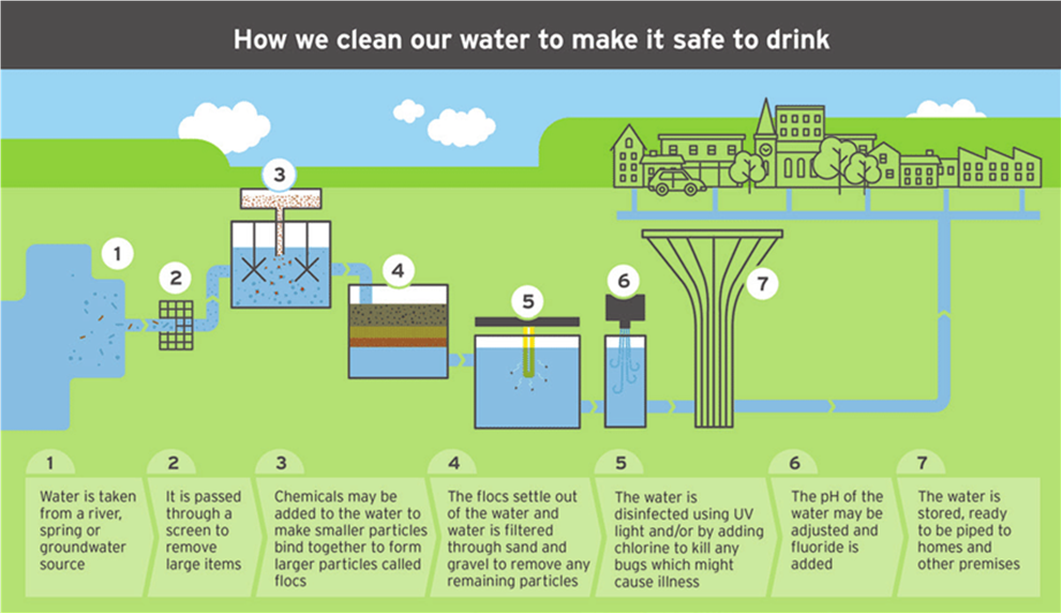 Naturalising gardens – protect green space & create buffer zones.
RIVER FLOODING & MANAGEMENT
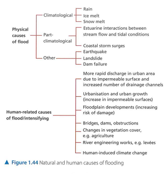 Flooding
Flooding occurs when the amount of water moving down a river exceeds the capacity of the river’s channel. The excess water overflows the banks & spills out across the floodplain.
Flooding is the most common in the middle & lower courses of rivers and occurs due to a variety of physical & human factors.
Natural:
Heavy precipitation - floods in UK associated with heavy rainfall of deep depressions (low-pressure system). In autumn & winter ; tend to be both long in duration & wide in area covered. River levels can rise very quickly during extremely high rainfall in area over short period of time. This can lead to flash floods.
Prolonged precipitation - continuous rainfall over long period of time may saturate soil. This results in rapid surface runoff causing river levels to rise rapidly & flow over their banks.
Seasonal variations in discharge - in India up to 70% of annual rainfall occurs in 100 days in summer. In the southwest monsoon ; melting snow in spring from mountain ranges e.g. Himalayas, Rockies & Alps. This can be responsible for widespread flooding in many countries.
Relief - steep slopes encourage rapid runoff ; potential for damage by floodwaters increases exponentially. This has velocity & speeds above 3m/s.
High tides - can stop water draining from rivers into sea ; has effect of pushing water back up river channel. This can result in flooding.
Other natural causes - high drainage density, impermeable rocks, lack of vegetation cover & soils with low infiltration capacity all encourage rapid runoff.
Human:
Urbanisation & urban growth - creation of highly impermeable surfaces reduces volume of water. This can infiltrate into ground & therefore increases runoff. Dense network of drains & sewers increases drainage density therefore runoff is transferred quickly into river channels. Due to increased storm runoff many sewerage systems cannot cope with resulting peak flow. Natural river channels often constricted by bridge supports or riverside facilities this reduces the channel's carrying capacity.
Floodplain development - increasing for housing (e.g. increased impermeable surfaces) & economic activity at expense of farming & forestry over past century in particular. Put higher percentage of people at risk of flooding in many countries
Human actions - deforestation & poor agricultural practices can reduce interception & increase runoff.
Human-induced climate change - warmer atmosphere can hold more moisture & subsequently release greater volumes of precipitation.
Higher temperatures can cause more 'rain-on-snow' events with warm rains. This causes faster & often earlier snowmelt. Hurricanes & other storm events predicted to become more frequent.
Groundwater flooding - generally occurs in low-lying areas where water table close to surface. Intense & prolonged precipitation may cause water table to reach surface & cause flooding and more than 10 times higher agricultural losses than river flooding. Large areas of Europe at risk of groundwater flooding
Impacts of Flooding
Damage & Destruction.
Loss of Habitats.
Disease.
Contamination of Water Supplies.
Provide Nutrients.
Recharges Groundwater Sources.
Flood Management:
Construction – the building of hard-engineering structures such as dams, flood embankments (raised artificial banks) or deepening the river channel.
Adaptation/Mitigation – flood control schemes that try to avoid or minimise potential flood damage. This involves working with nature rather than against it & it is called the soft engineering approach. For example, it might involve restoring a river or the marshland around it. Flood warning systems help people to be prepared.
Predictions – the prediction of river floods (their extent & depth) is helpful as it helps people to prepare & managing certain areas along a river.
Strategy | Description | Hard or soft? |
Dam | A dam is a barrier that stops of restricts the flow of surface water or underground streams. Reservoirs (lakes) created by dams not only suppress floods but also provide water for activities such as irrigation, human consumption. | Hard |
Planting Trees | Afforestation - planting trees where there has not been vegetation before. Reforestation - planting trees where deforestation has occurred. This increases interception and slows down the flow of water to rivers. Roots help to bind the soil and reduce impacts of erosion/landslides. | Soft |
Embankment/ Artificial Levees | These increase the river's carrying capacity (it can hold more water) due to the fact that the riverbanks become higher and therefore the channel becomes deeper. | Hard (Some Soft) |
Concrete Banks/ Walls | Similar to embankments used more frequently in built up areas to protect housing. | Hard |
Hazard Resistant Building Design | Making adjustments to buildings and their contents helps reduce losses. | Hard |
Dredging/ Digging the Channel | Silt builds up on the riverbed overtime. During heavy rain, the river floods, and silt builds up. Diggers or vacuum pumps can be used to remove silt and increase river capacity. However, after an extreme flood, the river accumulates more silt as the flow slows down. | Soft |
Straighten the River Channel | This encourages water to flow more quickly through an area so reducing the chance of flooding. | Soft |
Allow Flooding/ Managed Flooding | By allowing areas of lesser value to flood further up the course of a river, you reduce the risk of the river reaching its capacity in areas of higher value (urban areas). Some farmers will be paid compensation to allow their land to flood. | Soft |
Land-Use Zoning | Land-use zoning prevents construction of higher value on areas that frequently flood. | Soft |
Rescue Services/Early Warning Systems – Sometimes you can’t manage the flood, but you can try to reduce the impacts of flooding by evacuating people & ensuring that they are prepared. Warning systems & evacuation plans help to get people away from an area that is likely to flood. A well-funded emergency service is also a good thing to have.