Instrument Stage 2 Exam
1/49
There's no tags or description
Looks like no tags are added yet.
Name | Mastery | Learn | Test | Matching | Spaced |
|---|
No study sessions yet.
50 Terms
A contact approach is an approach procedure that may be used…?
A. In lieu of conducting an SIEP
You arrive at your destination airport on an IFR flight plan which prerequisite condition for the performance of a contact approach?
C. Clear of clouds and at least 1 statute mile of visibility
How wide is an SDF course?
Either 6 or 12 degrees
To ensure proper airspace protection while in a holding pattern above 14,000 feet in a propeller driven airplane, what is the maximum indicated airspeed a pilot should use?
A. 265 Knots
Which fixes on an IEP chart are initial approach fixes?
Any fix labeled as (IAF)
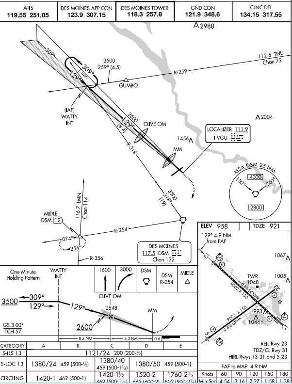
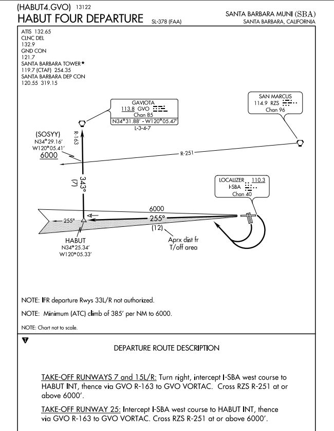
In figure 217, the symbol on the plan view on the ILS procedure represents minimum safe sector altitudes within 25 miles of…?
The VORTAC

In figures 174 and 175, at which point does the JEN.JEN9 arrival begin?
ABI VORTAC
Which clearance procedures may be issed by ATC without prior pilot request?
C. DP’S, STARS, and visual approaches
The standard IFR climb radiant is?
C. 200 feet per NM

In figure 235, what is the LPV decision altitude for the Lincoln RNAV GPS Runway 32?
1429 feet MSL
What feature is associated with temperature inversion?
A. A stable layer of air
Temperature and radiation variations over land with a clear sky typically lead to?
A. Minimum temperature occuring after sunrise
Under which conditions does advection fog usually form?
Moist air moving over colder ground or water
Clouds, fog, or dew, will always form when?
A. Water vapor condenses
Why is frost considered hazardous to flight operation?
C. Frost causes early airflow seperation resulting in a loss of lift.
Tailplane icing can be detected by
A. Elevator control pulsing, oscillations, or vibrations.
What type of icing should be expected when you encounter supercooled large droplets(SLD) that splash and splatter on impact at temperatures below -5 OAT.
C. Ice that forms on the wing aft of the active part of the deicing boots.
Which is true about ice formation on a wing surface?
Ice or frost formation on a wing surface can result in localized asymmetrical stalls on the wing resulting in roll control problems during liftoff.
Which is a characteristic of low level windshear as it relates to low level temperature inversions?
A. Allows airspeed to go above normal climb and approach speed.
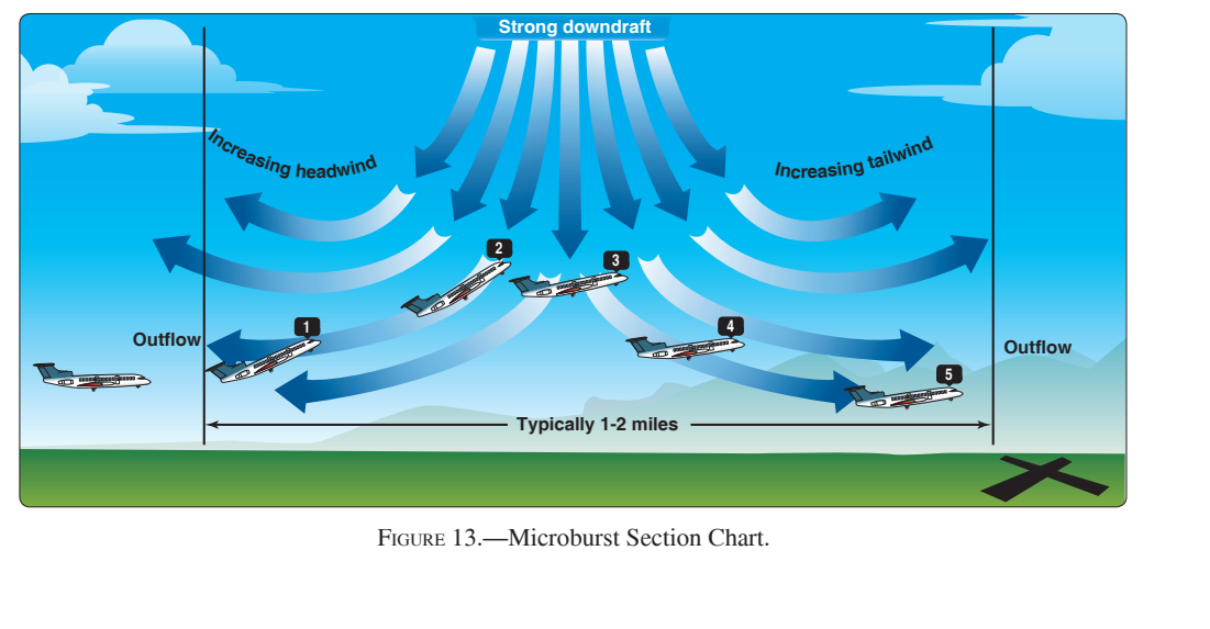
In figure 13, what will the microburst encounter have upon the aircraft in position 4?
Increasing tailwind and downdraft, resulting in loss of lift and airspeed.
ARMETS are issued on a scheduled basis every…?
C. 6 hours
The body of a TAF covers a geographical proximity within a…?
B. 5SM radius from the center of an airport runway complex.
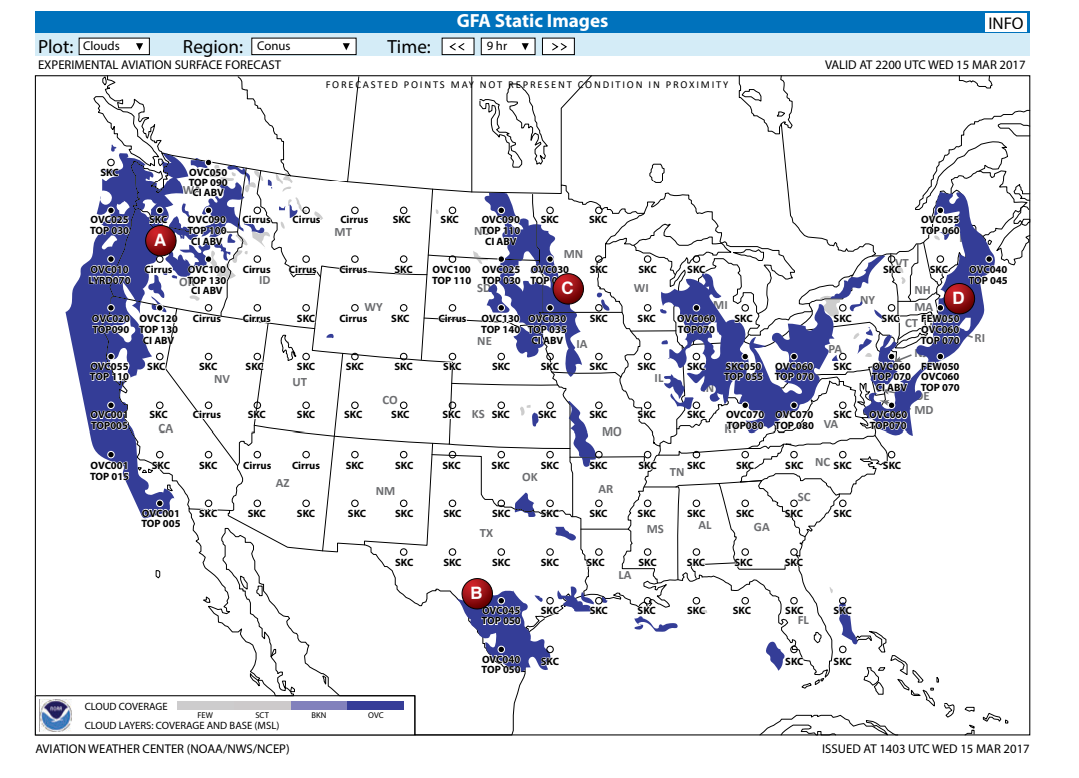
In figure 264, what does the term cirrus in area A indicate?
A.Clouds above FL 180
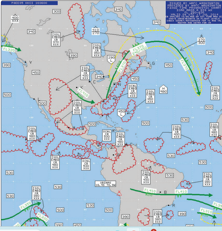
In figure 20, what is the height of the center of the low tropopause height over eastern Canada?
FL270
What determines how icing is reported on a pirep?
C. Rate of accumulation
What flight planning information can a pilot derive from constant pressure charts?
C. Winds and temperature aloft
What is the information provided by a convective outlook?
…thunderstorms
If you encounter in flight icing and ATC asks you to report your conditions, what are the offical icing reporting values that you are expected to use?
B. Trace, light, moderate, severe
The distance, measured in millibars, seperating isobars on surface analysis charts are typically…?
B. 4MB
Locations of fronts and pressure systems as of chart time are best determined by referring to a…?
C. Surface analysis chart
Reception of signals from an offshore radio facility may be inaccurate to identify the fix at the designated MEA, which altitude is designated from the fix?
A. MRA
Reception of signals from a radio facility located off the airway being flown may be inaccurate at the designated MEA to identify the fix, which altitude is designated from the fix?
B. MRA
ATC may assign the MOCA when certain special conditions exist and when within…?
A. 22 miles from a VOR
When must a pilot fly at a cardinal altitude + 500 feet on an IFR flight plan?
When assigned a VFR on top clearance
You have filed an IFR flight plan for a VFR on top clearance in lieu of an assigned altitude, if you receive this clearance when flying a course of 180, at what altitude should you fly assuming VFR conditions?
An even thousand foot MSL altitude +500 feet
What cruising altitude is appropriate for VFR on top westbound flight below 18,000 feet?
B. Even thousand foot levels + 500 feet, but not below MEA

In figure 89, what VHF frequency’s are available for communications with Cedar City FSS?
117.3
In figure 91, what are the two limiting cruising altitudes usable on V343 for a VFR on top clearance between the DBS VORTAC and RANEY?
An odd thousand +500 altitude
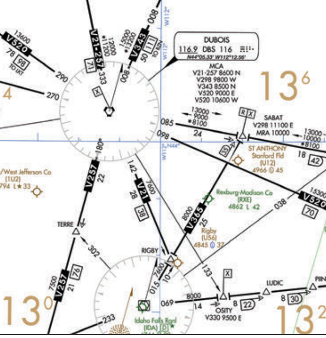
In figure 91, when flying a northbound IFR flight on V257 what is the minimum crossing altitude at the DBS VORTAC?
8,600 feet MSL

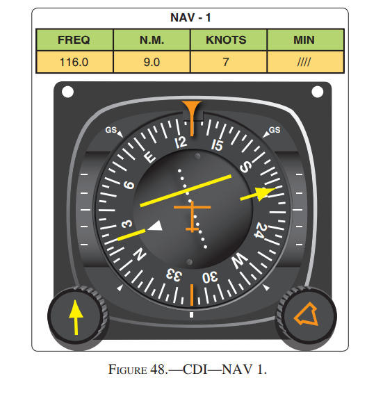
In figure 64, the CDI is centered, which indication on the number 1 and number 2 VOR receivers on the Lafayette regional airport would meet the requirements for a VOR check?
355 degrees, 4 degrees (FROM)
In figure 24, the winds are 230 at 40 knots, true airspeed is 130 knots, GPH 17.
Calculate on test
In figure 48, what is your position relative to 9 DME arc on the 206 radial of the instrument departure?
C. Inside the DME ARC
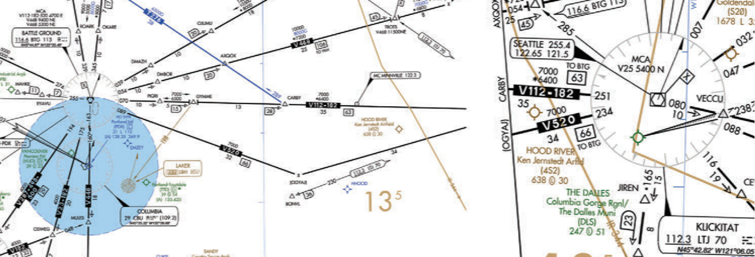
In figure 47, enroute from V112 to BTG VORTAC to LTJ VORTAC, the minimum altitude crossing the GYMME intersection is…?
7,000 feet MSL
In figure 189, your moving 100 knots, 385 feet per NM, what is the rate per NM?
643 feet per minute
In figure 91, where is your change over point (COP)?
Check on test
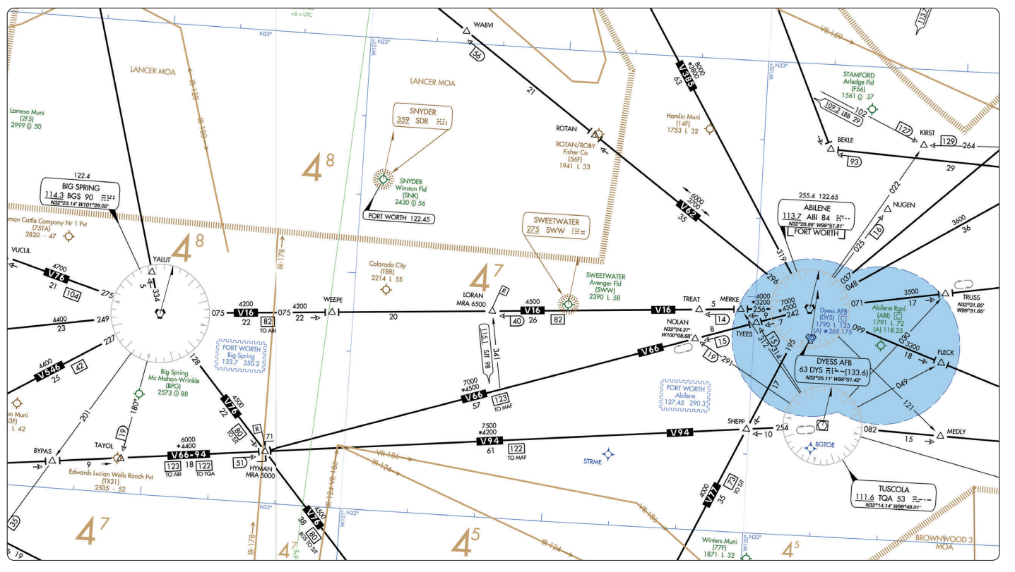
In figure 40, for planning purposes, what is the highest usable altitude for IFR flight from V16 between the BGS VORTAC and the ABI VORTAC?
Odd altitude plus 1000
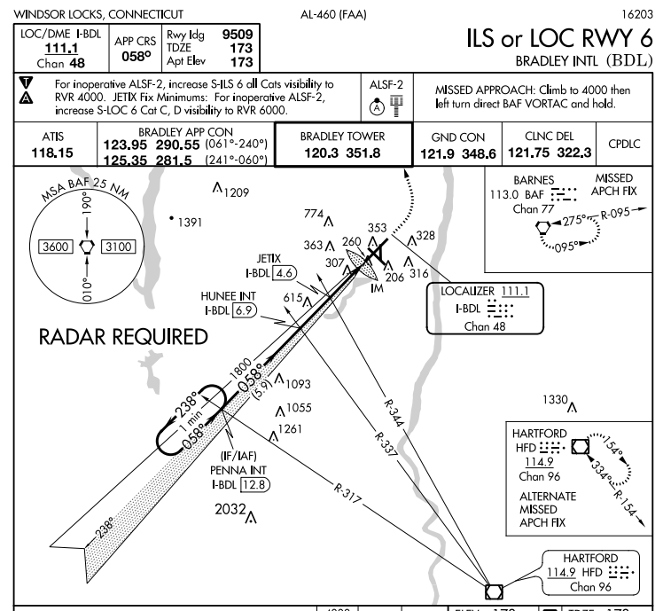
In figure 210 and legend 30, which landing and runway environment lighting is available for approach and landing on runway 6 at Bradley INTL?
ALSF-2 approach lighting

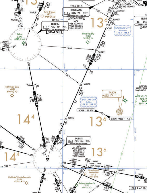
In figure 78, when eastbound on V86 between white hall and livingston the minimum altitude you should cross Bozeman is…?
10,200 feet
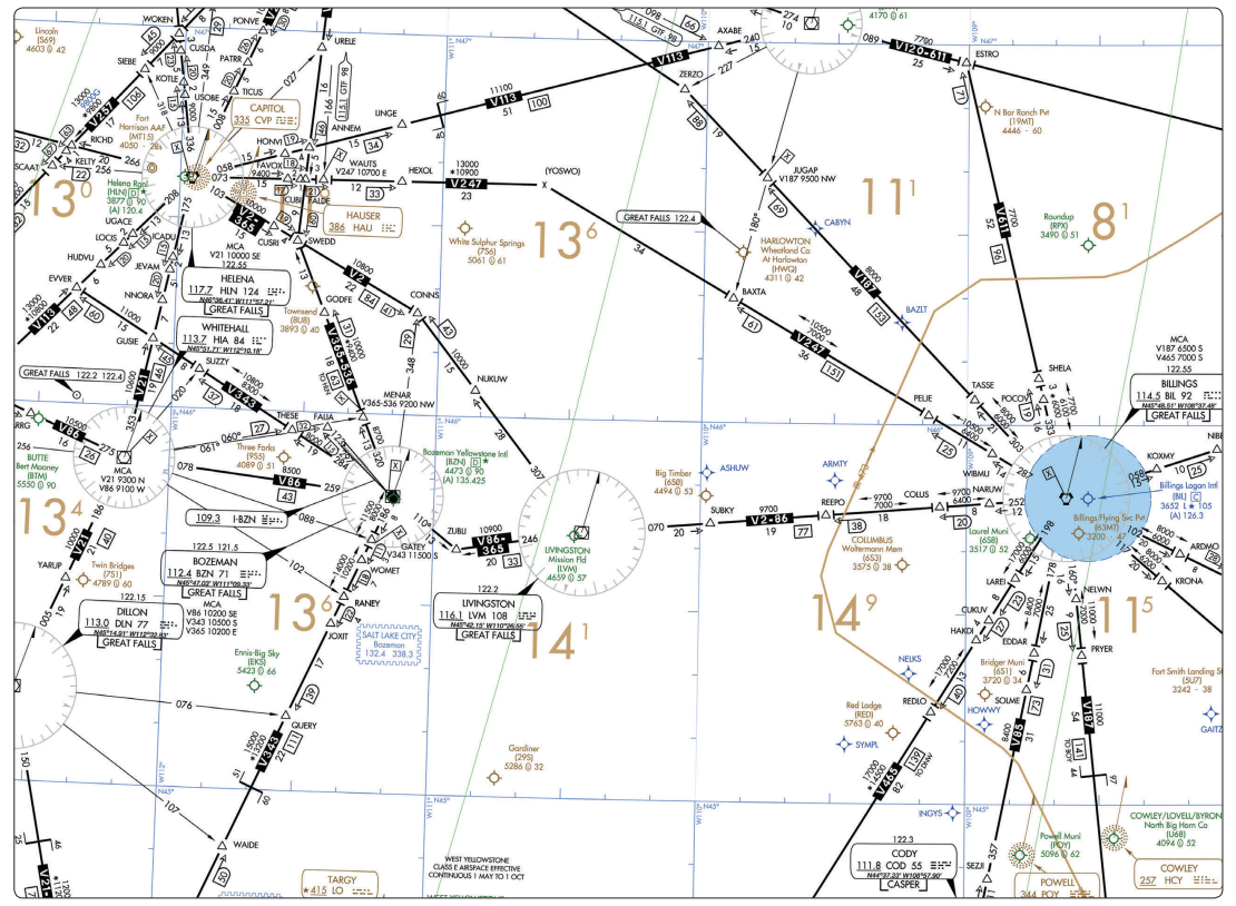
In figure 78, what is the maximum altitude you may flight plan an IFR flight on V86 eastbound between Bozeman and billings VORTACS?
Odd altitude +1000
Which aircraft approach category should be used for a circling approach for landing on runway 28 of an aircraft with a vso of 72 knots?
Category B